
| Area | Elk River |
| Topic | Vegetation: Turkey Foot CW Unit 1994 |
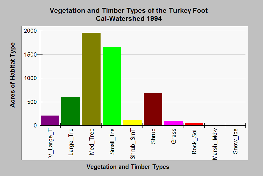
| Caption: This chart shows a summary of vegetation and timber types of the Turkey Foot Calwater Planning Watershed derived from a 1994 Landsat image. This area covers the headwater areas of the North Fork Elk River. The substantial small tree (6-11" dbh) and shrub components suggests recent timber harvest. While there is little old growth, which would fall in the very large tree category (>36" dbh), there was a substantial amount of medium (11-24" dbh) and large (24-36" dbh) trees as of 1994. Data provided by Humboldt State University with summaries by Institute for Fisheries Resources. See Info Links for more information. Vegetation classifications are: V_Large_T = Trees 36" in diameter at breast height (dbh), Large Trees = Trees 24-36" dbh, Med_Tree = Trees 11-24" dbh, Small Trees = Trees 6-11" dbh, and Shrub_SmT = Shrubs and small trees 1-6" dbh. Click on Picture to see an ArcView scene of the Calwater area showing vegetation types. | |
 |
To learn more about this topic click Info Links .
To view additional information (data source, aquisition date etc.) about this page, click Metadata .
To view the table with the chart's data, click Chart Table web page.
To download the table with the chart's data, click plseral3.dbf (size 8,462 bytes)
To download the table with the chart's data as an Excel spreadsheet, click plseral3.dbf.xls (size 17,294 bytes) .
| www.krisweb.com |