
| Area | Freshwater Creek-Ryan Slough |
| Topic | Vegetation: Camp 12 CW Watershed 1994 |
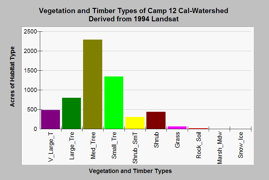
| Caption: The graph above shows a summary of vegetation and timber types of the Camp 12 Calwater planning watershed derived from a 1994 Landsat image (for more information click Info Links). This watershed is in Freshwater Creek around the community of Freshwater. There was a substantial component of medium sized trees (11-24") and large trees (24-36") as of 1994. Clear cuts in Little Freshwater Creek just prior to 1994 show up as shrub and grass components. Click on Picture to see an ArcView scene of the Camp 12 Calwater planning watershed showing vegetation types. Vegetation classifications are: V_Large_T = Trees 36" in diameter or greater, Large Trees = Trees 24-36" in diameter, Med_Tree = Trees 11-24" in diameter, Small Trees = Trees 6-11" in diameter Shrub_SmT = Shrubs and small trees 1-6" in diameter. | |
 |
To learn more about this topic click Info Links .
To view additional information (data source, aquisition date etc.) about this page, click Metadata .
To view the table with the chart's data, click Chart Table web page.
To download the table with the chart's data, click plseral3.dbf (size 8,462 bytes)
To download the table with the chart's data as an Excel spreadsheet, click plseral3.dbf.xls (size 17,294 bytes) .
| www.krisweb.com |