
| Area | Freshwater Creek-Ryan Slough |
| Topic | Vegetation: Upper Jacoby CW Unit 1994 |
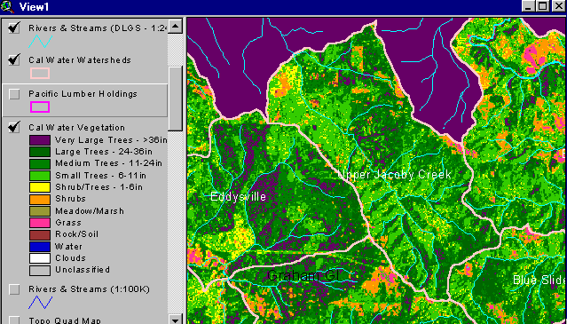
The vegetation image above is derived from a 1994 Landsat image which was classified by the Humboldt State University Spatial Analysis Lab (click on Info Links for more information about methods of classification). The area covered by the image is the Upper Jacoby Creek Calwater watershed planning unit. This watershed is characterized by dispersed early seral forests with small trees (11-16") and tree/shrub mixed dominating much of the watershed (light green with yellow patches). Small patches of orange in the photo may also be rural parcels with homesteads or pasture. A substantial portion of the very large trees (>36") remaining in the watershed in 1994 were in steeper areas at the top (east) of the watershed. Select the Zoom function and draw a box while using a left click on your mouse and get a closer view. Squares are 30 square meter pixels. Use the Pan function with a left click to move around the zoomed in view.
 Click on image to enlarge (45K).
To learn more about this topic click Info Links
To view additional information (data source, aquisition date etc.) about this page, click Metadata
| www.krisweb.com |