
| Area | Salmon Creek |
| Topic | Roads: Densities in Salmon Creek Sub-Basins 2000 |
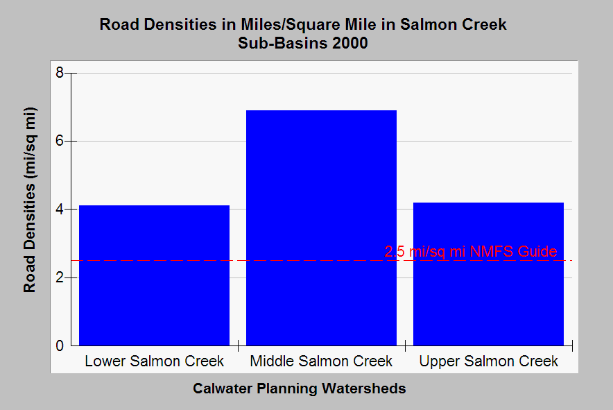
| Caption: This chart shows the road density in three Salmon Creek Calwater Planning Watersheds as miles of road per square mile of watershed. Densities in both exceed 4 mi/sq. mi. in all Calwaters. Properly functioning watershed condition for salmonids should be 2.5 mi./sq.mi. or less according to National Marine Fisheries Service (1996), which is shown as a reference above. Roads densities on timberlands may not reflect skid trails, temporary roads or tractor trails and so should be viewed as conservative. Data from Legacy the Landscape Connection with summary statistics generated by the Institute for Fisheries Resources. See Info Links for access to more background information. | |
 |
To learn more about this topic click Info Links .
To view additional information (data source, aquisition date etc.) about this page, click Metadata .
To view the table with the chart's data, click Chart Table web page.
To download the table with the chart's data, click sc_dens_xings.dbf (size 669 bytes)
To download the table with the chart's data as an Excel spreadsheet, click sc_dens_xings.dbf.xls (size 3,584 bytes) .
| www.krisweb.com |