
| Area | Salmon Creek |
| Topic | Vegetation: Landsat for Lower Salmon Cr Cal-Watershed 1994 |
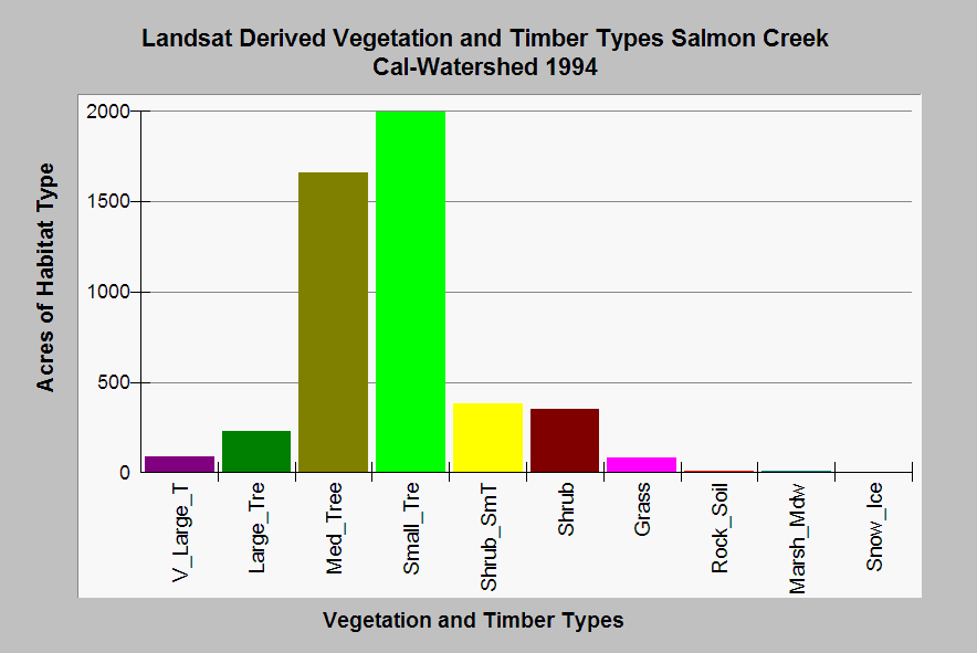
| Caption: This chart shows a summary of vegetation and timber types of the Salmon Creek Calwater planning watershed derived from a 1994 Landsat image (for more information click Info Links). The Salmon Creek Calwater watershed was in early succession, with a substantial component of small trees. Some of the acres of grass may actually be dairy lands in the west of the basin. Click on Picture to see pictures and map images. Vegetation classifications are: V_Large_T = Trees 36" in diameter or greater, Large Trees = Trees 24-36" dbh, Med_Tree = Trees 11-24" dbh, Small Trees = Trees 6-11" dbh, Shrub_SmT = Shrubs and small trees 1-6" in dbh. | |
 |
To learn more about this topic click Info Links .
To view additional information (data source, aquisition date etc.) about this page, click Metadata .
To view the table with the chart's data, click Chart Table web page.
To download the table with the chart's data, click plseral3.dbf (size 8,462 bytes)
To download the table with the chart's data as an Excel spreadsheet, click plseral3.dbf.xls (size 17,295 bytes) .
| www.krisweb.com |