
| Area | Shasta |
| Topic | Dissolved Oxygen: Max/Avg at Seven Shasta Locations 1986-92 |
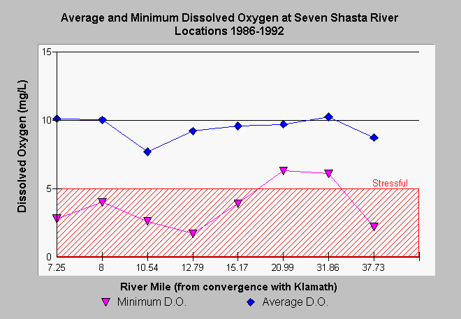
| Caption: According to Gwynne (1993), dissolved oxygen levels on the Shasta River drop to levels that are stressful or lethal for salmonids (<5 mg/l) and fail to meet minimum North Coast Regional Water Quality Control Board objectives (7 mg/l) at all stations measured. Scroll down in this box for a key to location of stations by river mile (rm). Minimum dissolved oxygen readings are the minimum of all readings for each station during the entire period of record (1986-1992). Acute problems with D.O. levels occur both in the upper Shasta Valley, just below Dwinell Dam (river mile 37.73), and in the reach from the Montague-Grenada Road (rm 15.17) to Highway 263 (rm 7.25). Dissolved oxygen problems may be moderated in the reach from Louie Road to below County Road A-12 by increased flows and cooler water from springs. (No adjustment for altitude was made in calculation of D.O. levels by Gwynne (1993), therefore values may be underestimated by approximately 10%). The River Miles (rm) above represent bridge crossings at the following locations: Highway 263 = rm 7.25, Anderson Grade Rd. = rm 8, Yreka-Ager Rd. = rm 10.54, Highway 3 = rm 12.79, Montague/Grenada Rd = 15.17, A-12 = rm 20.99, East Louie Rd. = rm 31.86, Riverside Dr. = rm 37.73. | |
 |
To learn more about this topic click Info Links .
To view additional information (data source, aquisition date etc.) about this page, click Metadata .
To view the table with the chart's data, click Chart Table web page.
To download the table with the chart's data, click gwdo.dbf (size 810 bytes) .
To view the table with the chart's source data, click Source Table web page.
To download the table with the chart's source data, click gwdocond.dbf (size 37,422 bytes)
| www.krisweb.com |