
| Area | Mainstem |
| Topic | Sediment: Road-Related Erosion Sources by Volume in Mill Cr 1998-99 |
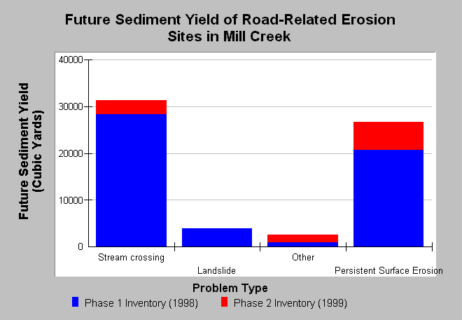
| Caption: This Chart shows future sediment yield from road-related potential erosion sites in Mill Creek, based on data collected during road surveys. Erosion from Stream Crossings, Landslides, and Other are sudden events, and their future sediment yield is calculated by multiplying total potential erosion by the probability of delivery to a stream. Persistent Surface Erosion is the gradual process of road wearing, and is estimated by multiplying the road and cutbank surface area by 0.2 inches per year over a 10-year period. Nearly all sites inventoried were recommended for treatment. Data were provided by the Mendocino County Resource Conservation District and Pacific Watershed Associates (1999). See Info Links for more information. | |
 |
To learn more about this topic click Info Links .
To view additional information (data source, aquisition date etc.) about this page, click Metadata .
To view the table with the chart's data, click Chart Table web page.
To download the table with the chart's data, click sed_road_mill_mcrcdpwa_98_99.db (size 18,432 bytes) .
To view the table with the chart's source data, click Source Table web page.
To download the table with the chart's source data, click sediment_road_mill_mcrcdpwa_1998.db (size 284,672 bytes)
| www.krisweb.com |