
|
Area/Topic | Bibliography | Background | Hypotheses | Home |
|
Map Page.
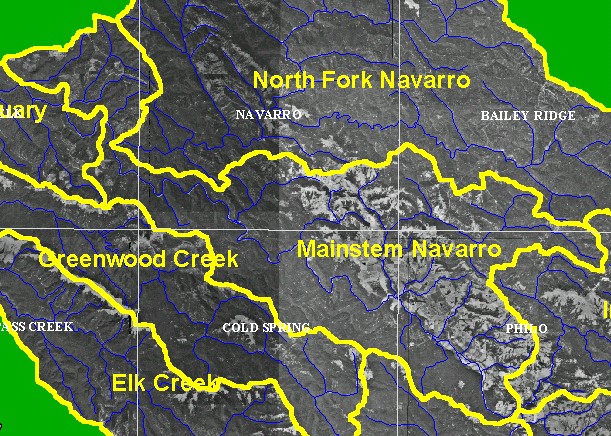
You selected the area Mainstem and the topic Map: 3A Digital Orthophotos (DOQs), Mainstem Navarro Sub-basin |
| This is a map showing digital orthophoto quarter-quadrangles (DOQs) in the Mainstem Navarro sub-basin, which were provided by the U.S. Geologic Survey. The agricultural areas and grasslands and oak woodlands are east of the mainstem Navarro, while coniferous forests cover the western and northern portions of the watershed. | |||
|
|
||
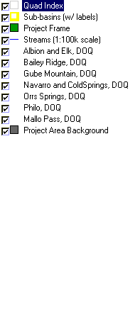
To view metadata about a map layer, click on a link in the table below.
| Name of Layer in Map Legend | Metadata File Name |
|---|---|
| Quad Index | quad_index.shp.txt |
| Sub-basins (w/ labels) | subbasins.shp.txt |
| Project Frame | Unavailable |
| Streams (1:100k scale) | streams100.shp.txt |
| Albion and Elk, DOQ | alb_elk.sid.txt |
| Bailey Ridge, DOQ | baileyridge.sid.txt |
| Gube Mountain, DOQ | gubemtn.sid.txt |
| Navarro and ColdSprings, DOQ | navar_coldsp.sid.txt |
| Ornbaun Valley- Southwest | ornbaun.sid.txt |
| Orrs Springs, DOQ | orrs_springs_sw.sid.txt |
| Philo, DOQ | philo.sid.txt |
| Mallo Pass, DOQ | mallopass.sid.txt |
| Zeni Ridge, DOQ | zeniridge.sid.txt |
| Topo Map (1:24k scale) | Unavailable |
| Gray Hillshade of Elevtn (TIFF) | grayscale_xnv.tif.txt |
| Project Area Background | Unavailable |
| www.krisweb.com |