
|
Area/Topic | Bibliography | Background | Hypotheses | Home |
|
Map Page.
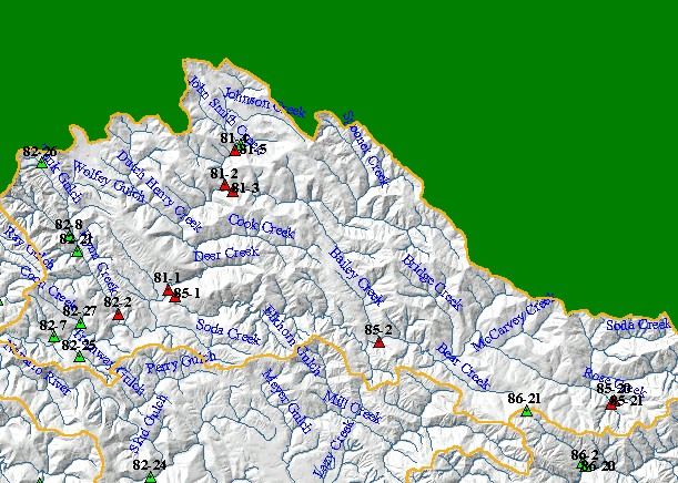
You selected the area North Fork and the topic Map: 1I Temperature Sites (MRC), North Fork Sub-basin, Hotlinked |
| This is a map of Mendocino Redwoods Company (MRC) water temperature monitoring stations in the North Fork Navarro sub-basin, displayed on top of 1:24,000 scale USGS hydrography and a grayscale hillshade of elevation. Stations shown in red are hotlinked to charts. To view a chart, use the hotlink tool (lightning bolt icon) to click on a red point. Scale = 1:159,220 . | |||
|
|
||
To view metadata about a map layer, click on a link in the table below.
| Name of Layer in Map Legend | Metadata File Name |
|---|---|
| MRC Temperature Stations (89-01) | temp89_01.shp.txt |
| MRC Temperature Stations (89-01) | temp89_01.shp.txt |
| Sub-basins (no labels) | subbasins.shp.txt |
| Streams (1:24k scale)(w/ labels) | streams24.shp.txt |
| Topo Map (1:24k scale) | Unavailable |
| Gray Hillshade of Elevtn ((TIFF) | grayscale_xnv_light.tif.txt |
| Project Frame | Unavailable |
| www.krisweb.com |