
| Area | Guerneville |
| Topic | Land Cover: EPA Land-Use - Guerneville Sub-basin, East 1992 |
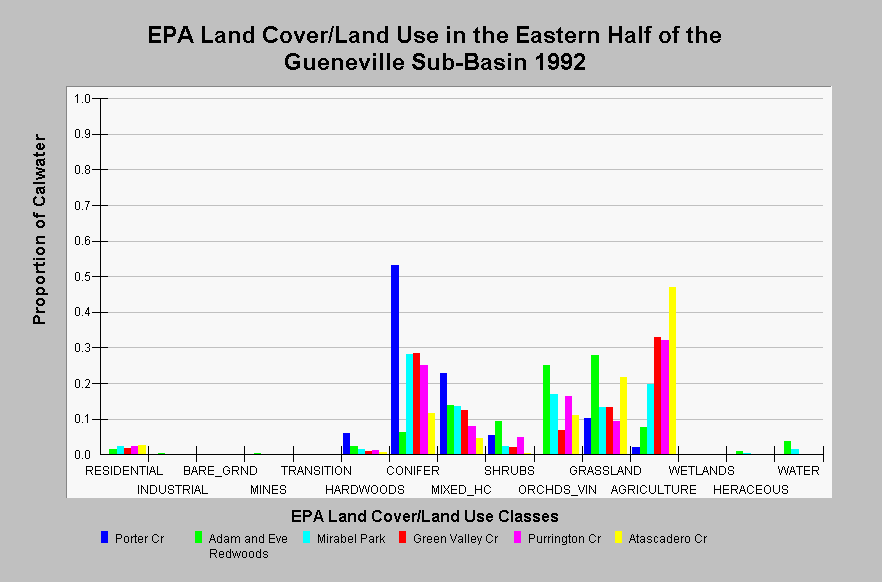
| Caption: This chart displays EPA Land Cover/Land Use data by Calwater Planning Watershed in the eastern half of the Guerneville sub-basin. Classes are derived from a 1992 Landsat image. The Porter Creek Calwater mainly consists of conifer forest and contains areas of mixed hardwood/conifer, and grasslands. The remaining Calwater Planning Watersheds shown contain conifer and mixed hardwood/conifer forests in to the west and transition to grasslands, agriculture and orchards, and vineyards in the east. All Calwater Planning Watersheds, excluding Porter Creek, contain residential areas. The water category includes the Russian River and adjacent gravel pits. Click on the Map tab to view the EPA Land Cover/Land Use GIS layer. Click on InfoLinks for more information. | |
 |
To learn more about this topic click Info Links .
To view additional information (data source, aquisition date etc.) about this page, click Metadata .
To view the table with the chart's data, click Chart Table web page.
To download the table with the chart's data, click landcover_epa_guerneville_1992.dbf (size 2,730 bytes) .
To view the table with the chart's source data, click Source Table web page.
To download the table with the chart's source data, click landcover_epa_russian_calwaters_1992.dbf (size 28,330 bytes)
| www.krisweb.com |