
| Area | Geyserville |
| Topic | Land Cover: EPA Land-Use - Geyserville Sub-basin, Upper 1992 |
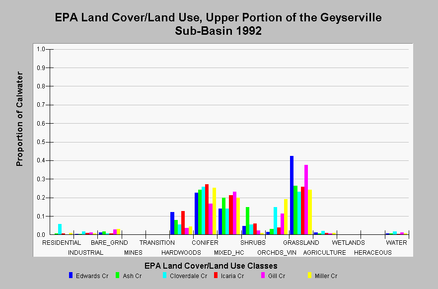
| Caption: This chart displays EPA Land Cover/Land Use data by Calwater Planning Watershed for the upper portion of the Geyserville sub-basin. Classes are derived from a 1992 Landsat image. Grasslands dominate Alexander Valley and the eastern ridges, while conifer, mixed hardwood/conifer, hardwoods, and shrubs are located on western hillslopes, within swales and adjacent to some streams. Orchards and vineyards and agriculture areas are typically located within Alexander Valley. Bare ground represents gravel bars along the Russian River and water includes the Russian River and adjacent gravel pits. The Cloverdale Creek Calwater contains 5.7% residential area. Small proportions of all Calwater Planning Watersheds contain industrial areas. Click on the Map tab to view the EPA Land Cover/Land Use GIS layer. Click on InfoLinks for more information. | |
 |
To learn more about this topic click Info Links .
To view additional information (data source, aquisition date etc.) about this page, click Metadata .
To view the table with the chart's data, click Chart Table web page.
To download the table with the chart's data, click landcover_epa_geyserville_1992.dbf (size 3,758 bytes) .
To view the table with the chart's source data, click Source Table web page.
To download the table with the chart's source data, click landcover_epa_russian_calwaters_1992.dbf (size 28,330 bytes)
| www.krisweb.com |