
| Area | Santa Rosa |
| Topic | Land Cover: EPA Land-Use - Santa Rosa Sub-basin, North 1992 |
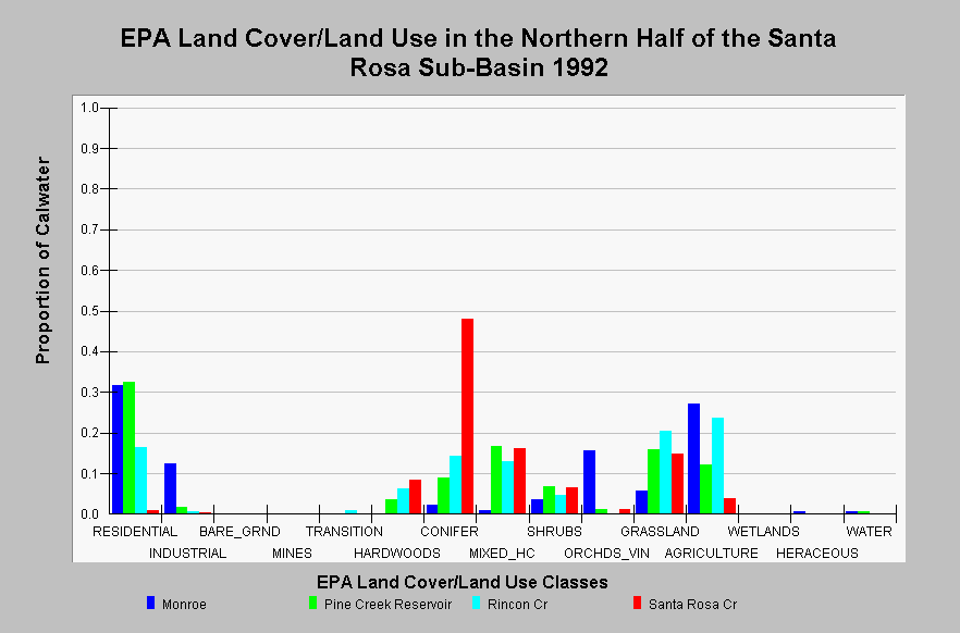
| Caption: This chart displays EPA Land Cover/Land Use data by Calwater Planning Watershed in the northern half of the Santa Rosa sub-basin. Classes are derived from a 1992 Landsat image. The Monroe Calwater is largely developed containing 31.7% residential, 27.0% agriculture, 15.5% orchard and vineyards, and 12.3% industrial. Pine Creek Reservoir and Rincon Creek contain high proportions of residential area (32.6% and 16.4%, respectively) and moderate proportions of agriculture, grasslands and mixed hardwood/conifer forest. The Santa Rosa Creek Calwater is the least developed and is dominated by conifer (48.0%), mixed hardwood/conifer forest, and grasslands. Click on the Map tab to view the EPA Land Cover/Land Use GIS layer. Click on InfoLinks for more information. | |
 |
To learn more about this topic click Info Links .
To view additional information (data source, aquisition date etc.) about this page, click Metadata .
To view the table with the chart's data, click Chart Table web page.
To download the table with the chart's data, click landcover_epa_santarosa_1992.dbf (size 1,609 bytes) .
To view the table with the chart's source data, click Source Table web page.
To download the table with the chart's source data, click landcover_epa_russian_calwaters_1992.dbf (size 28,330 bytes)
| www.krisweb.com |