
| Area | Santa Rosa |
| Topic | Land Cover: EPA Land-Use - Santa Rosa Sub-basin, South 1992 |
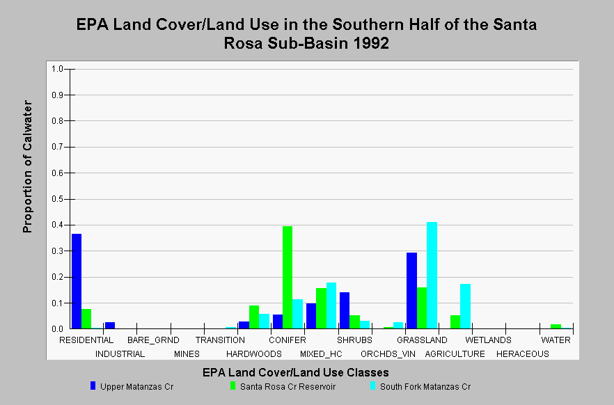
| Caption: This chart displays EPA Land Cover/Land Use data by Calwater Planning Watershed in the southern half of the Santa Rosa sub-basin. Classes are derived from a 1992 Landsat image. The Upper Matanzas Creek Calwater is composed of 36.4% residential, 29.4% grassland, 14% shrub land, 9.7% mixed hardwood/conifer, some hardwood and conifer areas, and 2.5 % industrial. The Santa Rosa Creek Reservoir Calwater is 39.3% conifer, 15.9% grassland, 15.5% mixed hardwood/conifer, 9% hardwoods, and contains 7.6% residential and 5.2% agriculture. South Fork Matanzas Creek Calwater is mainly grassland (40.9%), agriculture (17.3%), mixed hardwood/conifer (17.8%), and contains some conifer and hardwood areas. Click on the Map tab to view the EPA Land Cover/Land Use GIS layer. Click on InfoLinks for more information. | |
 |
To learn more about this topic click Info Links .
To view additional information (data source, aquisition date etc.) about this page, click Metadata .
To view the table with the chart's data, click Chart Table web page.
To download the table with the chart's data, click landcover_epa_santarosa_1992.dbf (size 1,609 bytes) .
To view the table with the chart's source data, click Source Table web page.
To download the table with the chart's source data, click landcover_epa_russian_calwaters_1992.dbf (size 28,330 bytes)
| www.krisweb.com |