
| Area | Ukiah |
| Topic | Land Cover: EPA Land-Use - Ukiah Sub-basin, Northwest 1992 |
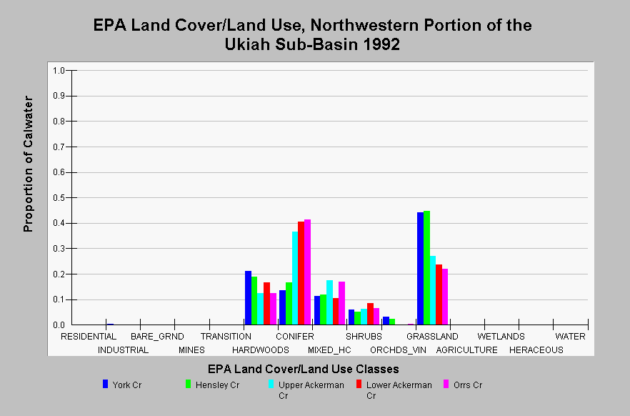
| Caption: This chart displays EPA Land Cover/Land Use data by Calwater Planning Watershed for the northwestern portion of the Ukiah sub-basin. Classes are derived from a 1992 Landsat image. These Calwater Planning Watersheds are composed of grasslands, conifer, mixed hardwood/conifer, hardwoods, and shrubs. Forested are tend to be located within swales and adjacent to streams. Some orchard and vineyard areas are contained in York, Hensley, and Orrs creeks. Click on the Map tab to view the EPA Land Cover/Land Use GIS layer. Click on InfoLinks for more information. | |
 |
To learn more about this topic click Info Links .
To view additional information (data source, aquisition date etc.) about this page, click Metadata .
To view the table with the chart's data, click Chart Table web page.
To download the table with the chart's data, click landcover_epa_ukiah_1992.dbf (size 5,271 bytes) .
To view the table with the chart's source data, click Source Table web page.
To download the table with the chart's source data, click landcover_epa_russian_calwaters_1992.dbf (size 28,330 bytes)
| www.krisweb.com |