
| Area | Ukiah |
| Topic | Land Cover: EPA Land-Use - Ukiah Sub-basin, Valley Areas 1992 |
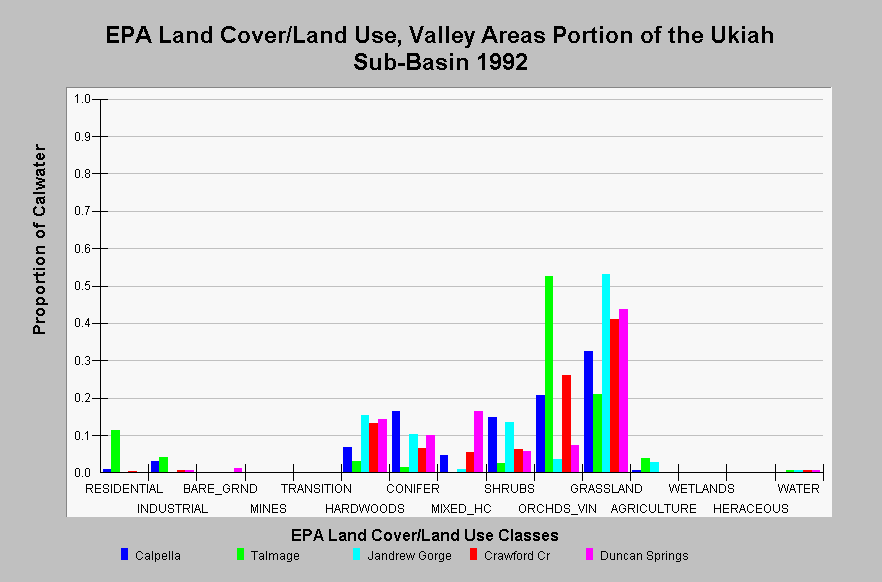
| Caption: This chart displays EPA Land Cover/Land Use data by Calwater Planning Watershed for the valley areas adjacent to the Russian River within the Ukiah sub-basin. Classes are derived from a 1992 Landsat image. These Calwater Planning Watersheds are dominated by grasslands, orchards and vineyards. Hardwoods, conifer, mixed hardwood/conifer, and shrubs are found on the foothills and along canyon areas. Residential areas in Calpella (0.9%) and Talmage (11.4%) represent the city and sub-urban areas of Ukiah. Industrial areas are found in all Calwater Planning Watersheds except Jandrew Gorge. Little agriculture is found in Calpella, Talmage, and Jandrew Gorge. Click on the Map tab to view the EPA Land Cover/Land Use GIS layer. Click on InfoLinks for more information. | |
 |
To learn more about this topic click Info Links .
To view additional information (data source, aquisition date etc.) about this page, click Metadata .
To view the table with the chart's data, click Chart Table web page.
To download the table with the chart's data, click landcover_epa_ukiah_1992.dbf (size 5,271 bytes) .
To view the table with the chart's source data, click Source Table web page.
To download the table with the chart's source data, click landcover_epa_russian_calwaters_1992.dbf (size 28,330 bytes)
| www.krisweb.com |