
| Area | Warm Springs |
| Topic | Land Cover: EPA Land-Use - Warm Springs Sub-basin, Middle 1992 |
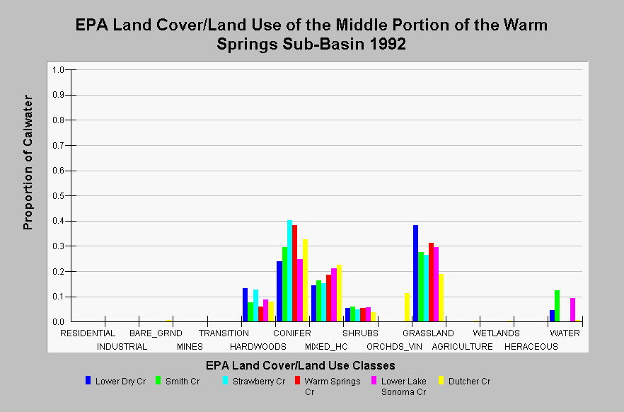
| Caption: This chart displays EPA Land Cover/Land Use data by Calwater Planning Watershed of the middle portion of the Warm Springs sub-basin. Classes are derived from a 1992 Landsat image. These Calwater Planning Watersheds are typically dominated by grasslands, conifer, mixed hardwood/conifer, hardwoods, and shrubs. Forested areas tend to be located within swales and adjacent to streams. Sonoma lake is represented as the water proportion of Lower Dry Creek, Smith Creek, and Lower Lake Sonoma Calwater Planning Watersheds. Click on the Map tab to view the EPA Land Cover/Land Use GIS layer. Click on InfoLinks for more information. | |
 |
To learn more about this topic click Info Links .
To view additional information (data source, aquisition date etc.) about this page, click Metadata .
To view the table with the chart's data, click Chart Table web page.
To download the table with the chart's data, click landcover_epa_warmsprings_1992.dbf (size 3,434 bytes) .
To view the table with the chart's source data, click Source Table web page.
To download the table with the chart's source data, click landcover_epa_russian_calwaters_1992.dbf (size 28,330 bytes)
| www.krisweb.com |