
| Area | Basin-wide/Regional |
| Topic | Land Use: Farm Size Distribution in 3 Sheepscot Counties, 1987-1997 |
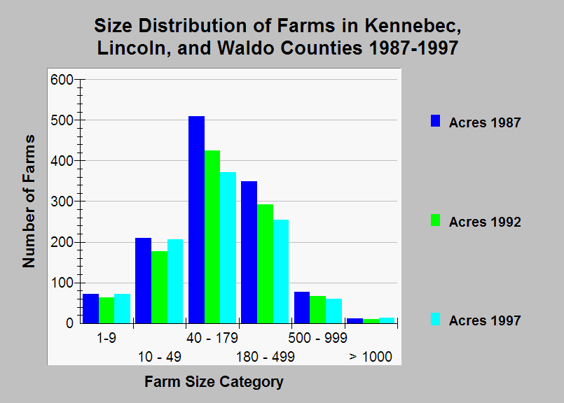
| Caption: This chart shows the change in the size distribution of farms in Kennebec, Lincoln, and Waldo counties during the period 1987-1997. These three counties comprise most of the Sheepscot watershed and summed together in this graph. The total number of farms declined from 1230 in 1987 to 1035 in 1992 to 980 in 1997, a total decrease of 20 percent. The number of the smallest (less than 50 acres) and largest farms (greater than 1000 acres) remained stable while the number of medium and large farms declined substantially. Note that the data are for the entire extent of the each county, not just the pieces that are in the Sheepscot watershed. Data were collected by the U.S. Census of Agriculture. See Info Links for more information. | |
 |
To learn more about this topic click Info Links .
To view additional information (data source, aquisition date etc.) about this page, click Metadata .
To view the table with the chart's data, click Chart Table web page.
To download the table with the chart's data, click land_use_sheepcounties_census_87_99_farmsize.db (size 4,096 bytes)
To download the table with the chart's data as an Excel spreadsheet, click land_use_sheepcounties_census_87_99_farmsize.db.xls (size 4,096 bytes) .
| www.krisweb.com |