| Area |
Mainstem Sheepscot |
| Topic |
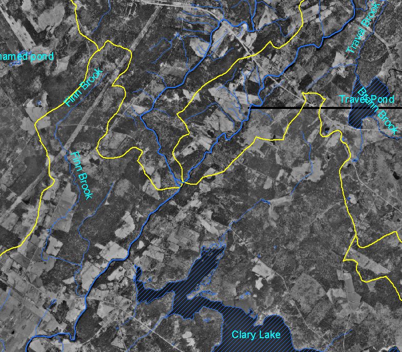
Map: 1G. Digital Orthophotos 1997, West Branch - Mainst. Confluence |
To view a more detailed version of this map click
here
|
This is a map showing 1997 digital orthophoto quarter-quadrangles (DOQs)of the confluence of the West Branch Sheepscot and mainstem Sheepscot
Rivers (same extent as adjacent 1940 topic), displayed with sub-basin outlines and major roads. One striking difference between the 1940 and 1997
photographs is that Clary Lake did not exist in 1940. DOQs were provided by the U.S. Geological Survey and Maine Office of GIS. Use the Pan (hand
icon) and Zoom (magnifying glass icons) tools to move around the map.
|
|
|
 |
 |
To view metadata about a map layer, click on a link in the table below.
| Name of Layer in Map Legend | Metadata File Name |
|---|
| Streams (1:24k scale)(w/ labels) | stream24_sheep.shp.txt |
| Mainstem and WB Sheepscot River | shpscotriv24.shp.txt |
| Subbasins (no labels) | subbasins.shp.txt |
| Atlantic Ocean, Bays, and Estuaries | Unavailable |
| Waterbodies (w/ labels) | sheeppnd.shp.txt |
| Bristol - 1997 DOQ (SID) | Unavailable |
| Boothbay Harbor - 1997 DOQ (SID) | Unavailable |
| China Lake - 1997 DOQ (SID) | Unavailable |
| Damariscotta - 1997 DOQ (SID) | Unavailable |
| East Pittston - 1997 DOQ (SID) | Unavailable |
| Jefferson - 1997 DOQ (SID) | Unavailable |
| Liberty - 1997 DOQ (SID) | Unavailable |
| North Whitefield - 1997 DOQ (SID) | Unavailable |
| Palermo - 1997 DOQ (SID) | Unavailable |
| Razorville - 1997 DOQ (SID) | Unavailable |
| Washington - 1997 DOQ (SID) | Unavailable |
| Weeks Mills - 1997 DOQ (SID) | Unavailable |
| Wiscasset - 1997 DOQ (SID) | Unavailable |
| Westport - 1997 DOQ (SID) | Unavailable |
If you obtain KRIS on a CD and install it on your hard drive as a desktop program, you will have access to increased map capabilities such as zooming in/out, turning layers on/off, adding layers and changing legends.
