Bibliography Background About KRIS
Hypothesis #2: High levels of sediment in Ten Mile River tributaries have caused habitat changes which limit coho salmon production.
Support for hypothesis from the Literature
McNeil and Ahnell (1964) pointed out that excessive sediment can limit salmonid reproduction and survival (see also Sediment page). Chapman (1988) also recognized that the damaging effects of fine sediment in salmonid nests but stated that not enough experiments had been conducted to measure conditions within redds. McHenry et al. (1994) built artificial redds in Olympic Peninsula streams and placed coho salmon and steelhead eggs in them. They found that: "when fine sediments (<0.85 mm) exceeded 13%, salmonid survival dropped drastically. This suggests the existence of a threshold over which survival is very low." Although some fine sediment is removed when the female coho digs the redd, particles less than 0.85 mm are highly mobile and may re-enter the redd, even during moderate flows, if they are at very high levels in the stream bed (Beschta and Jackson, 1979).
Barnard (1992) measured fine sediment less than 1 mm in Freshwater Creek, a tributary of Humboldt Bay, inside and outside coho salmon redds and found an average of 7.5% inside and 13.1% outside. Freshwater Creek has very unstable soil types but the watershed had at least 40 to 50 years of rest from logging prior to measurements in 1988. These studies are consistent with a 14% target for fine sediment <0.85mm set by the Ten Mile River TMDL (US EPA, 2000). Kondolf (2000) surveyed the literature and found that an average of ten studies showed 50% mortality of eggs and alevin in salmon redds when sand sized particles (< 6.4 mm) comprise 30% of the stream bed.
Habitat typing surveys visually estimate embeddedness of potential spawning gravels (McCain et al., 1990) and the California Department of Fish and Game (1998) has characterized good spawning substrate as less than 25% embedded. Excessive sediment may also reduce pool volume and frequency, potentially reducing the survival of coho salmon which use pools as rearing habitat. CDFG (1998) characterized streams with greater than 40% pool frequency as being healthy salmonid habitat. Murphy et al. (1984) found pool frequencies of 39-67% in undisturbed streams. Brown et al. (1994) noted the importance of having pools deeper than a meter (39 inches) for coho juvenile rearing, and stated that loss of pools was a principal cause for loss of coho salmon in northwestern California.
From Ten Mile River Data
The Ten Mile River is recognized with regard to sediment under section 303d of the Clean Water Act and a Ten Mile River Total Maximum Daily Load for Sediment (US EPA, 2000) has been prepared. The report states that: "High concentrations of channel-bottom fine sediment, excessive gravel embeddedness, inadequate pool frequency and depth, and lack of large woody debris appear to be factors directly and indirectly related to sediment that are currently limiting the success of salmonids, especially coho salmon, throughout the watershed." Those findings are consistent with other data which show levels of fine sediment in gravels that are over thresholds for optimal coho egg and alevin survival, and habitat typing data shows that pool availability and pool depth are much lower than optimum for coho salmon rearing.
Georgia Pacific (Ambrose et al., 1996; Ambrose and Hines, 1996 and 1997) and Hawthorne Timber Company (HTC) (Hines, 2000) present a wealth of fine sediment data for the Ten Mile River basin. The McNeil samples were process by the wet-sieve method and are thus comparable to TMDL targets and other reviews of wet-sieve data. Twenty-four of 27 monitored sites had more than 14% fines smaller than 0.85 mm, the Ten Mile TMDL target (US EPA, 2000). Fine-gravel sized particle measurements (<6.4 mm) for all sites exceeded 30% in some or all years. The South Fork Ten Mile makes a useful case study because surveys of coho juvenile there since 1993 show that the population has dropped significantly. All but two sites on the South Fork exceeded 14% fines less than 0.85mm (see chart below) when values from all years were averaged.
Georgia Pacific (1996) habitat typing surveys found embeddedness levels at the majority Ten Mile River tributary stations to be greater than 75% (see chart below). The California Department of Fish and Game (1998) considers less than 25% embeddedness to be optimal for salmon. Embeddedness values indicate stream armoring and sediment levels likely to be deleterious to coho salmon spawning and egg and alevin survival. The same reports (Georgia Pacific, 1996) show less than 20% pool frequencies in many Ten Mile River tributaries with only two main river reaches having a healthy pool ratio of 40%. Habitat typing surveys also show a high occurrence of dry habitats where aggradation has caused a loss of surface flow, certainly a major constraint on fish production. Pool depths in the Ten Mile River are shallow and several reaches have no pools deeper than three feet (see chart below). High sediment levels are clearly decreasing suitability for coho salmon by causing a loss of suitable spawning and rearing habitat.
Source Topics: The charts below are derived from the Topics listed here. Check these Topics in the KRIS database to see information in context and to have access to Info Links and Metadata.
(SF) Sediment: Fine Sediment (<0.85 mm) Avg SF Tributary Sites 1993-2001
(SF) Sediment: Fine Sediment (<6.4 mm) Avg @ Mainstem SF Sites 1993-2001
(SF) Sediment: Fines <0.85 mm (SFT 1) in Lower Smith Creek 1993-2001
(SF) Sediment: Fines <6.4 mm (SFT 2) Lower Campbell Cr 1993-2001
(LT) Habitat: Pool Tail Embeddedness
(BW) Habitat: Pool Frequency and Habitat Types by Length
(BW) Habitat: Maximum Pool Depths
(BW) Sediment: V* for Ten Mile and Nearby Streams 1992
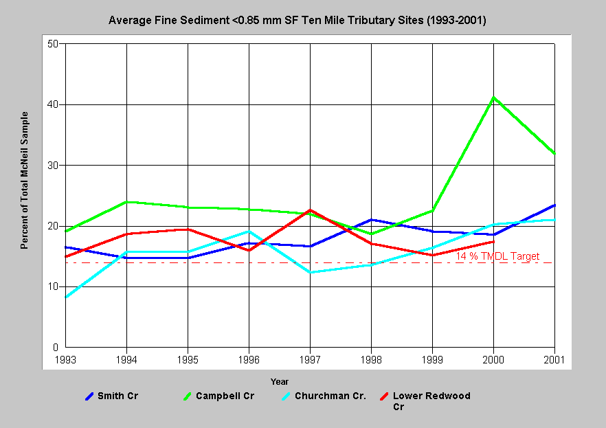 Average percent fine sediment less than 0.85 mm from McNeil samples in South Fork Ten Mile River tributary monitoring sites are displayed at left for the years 1993 to 2001. With the exception of Churchman Creek in three years, the average values are all above the TMDL target of 14%. Three of four sites show an increasing trend (see individual site topics for confidence intervals). Campbell Creek shows the largest increase of all tributary sites, far exceeding suitability for salmonids in 2000 and 2001.
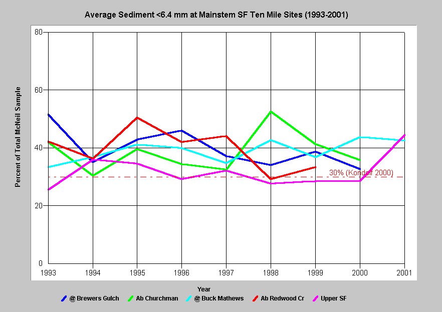 Average values for percent fine sediment less than 6.4 mm range from 25% to 53% for all sites in the South Fork Ten Mile sampled from 1993 to 2001. These proportions of sand and small gravel are much higher than optimal for salmonid egg and alevin survival. The reference of 30% is associated with 50% survival to emergence (Kondolf 2000). This broad category of fine sediment (<6.4 mm) is responsible for suffocating eggs and blocking the emergence of alevin.
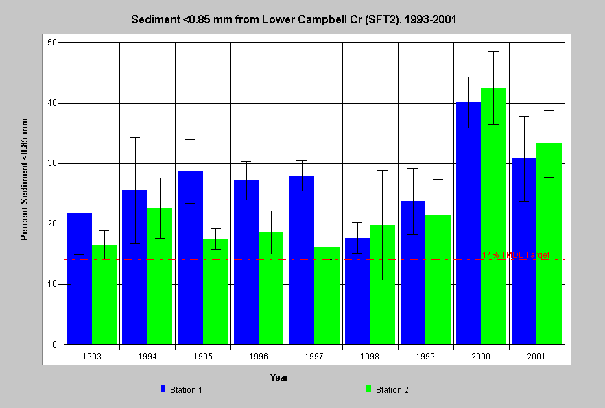 Fine sediment less than 0.85 mm in lower Campbell Creek, South Fork Ten Mile River, was greater than 14% in almost all years since 1993, including standard error range. Both stations showed a large increase since 2000. The Campbell Creek watershed was more than 80% logged between 1988 and 1999. The sustained period of over-threshold sediment is synchronous with the apparent decline of coho. Although coho were present in Campbell Creek electrofishing samples in 1995-97, they have been absent from samples in 1998 and 2000 (see Hypothesis #1).
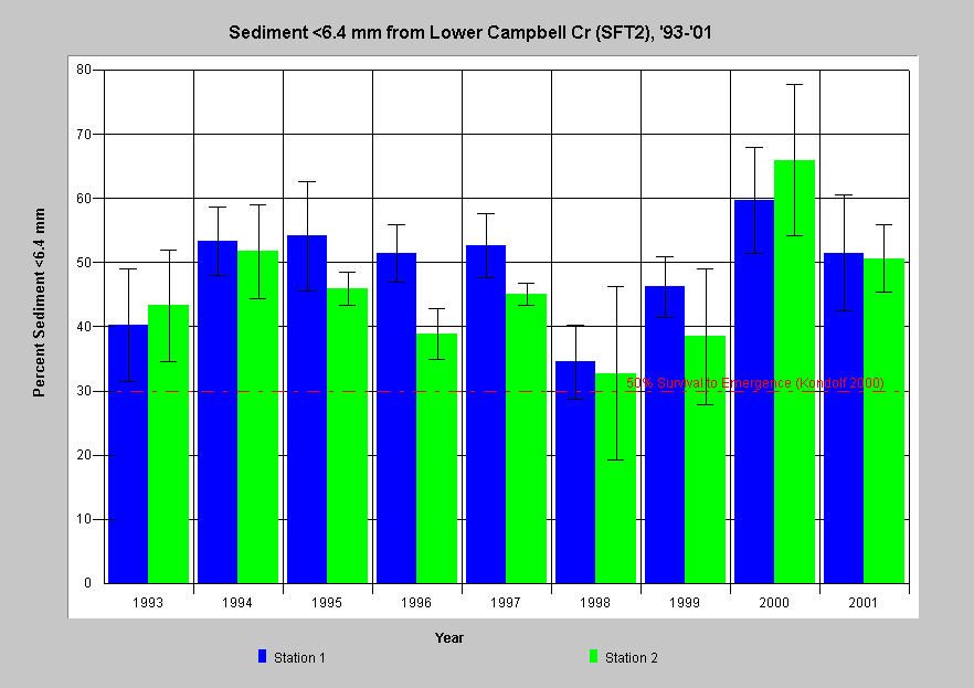 Fine sediment less than 6.4 mm in Campbell Creek, South Fork Ten Mile River has also been significantly greater than 30% in the periods 1993-1997 and 2000-2001. The data suggest pulses of unstable bedload and are contemporaneous with a high level of watershed disturbance. The dip in fines in 1998 was likely related to sustained high flows, which flushed sand and small gravels downstream. The resurgence of fines less than 6.4 mm indicates that supply from unstable upslope areas continue. Sediment supply in this size class is highly mobile and form an impermeable layer or cap that keeps alevin from emerging as fry from redds.
 Habitat surveys in 1995-1996 showed that most pool tails (spawning areas) are highly embedded with sediment in Ten Mile River Basin tributaries. Twenty of twenty-five reaches surveyed in the Ten Mile River had more than 50% of pool tails in the highest embeddedness class (>75%). Only Bald Hill Creek and three other North Fork tributaries had more than 20% of pool tails in optimal or fair condition for spawning fish. The high embeddedness in South Fork Ten Mile reaches is consistent with fine sediment shown at HTC sites.
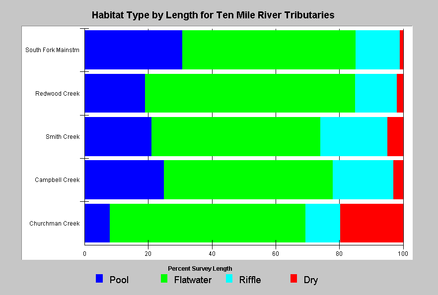 Habitat surveys in 1995-1996 of the South Fork Ten Mile River showed that pool habitat comprised 31% of stream habitat by length in the mainstem but as little as 8% of Churchman Creek stream habitats. The chart at left also shows riffles, flatwater habitat or dry channel. The low pool frequency and substantial dry reaches suggest that the stream is highly aggraded. Young coho and older age steelhead juveniles require pools as rearing habitat and all salmonids require habitat with surface flow. CDFG rates good salmonid streams as those with greater than 40% pool habitat. Lack of pools is likely limiting coho salmon production in the Ten Mile River basin.
 Habitat surveys in 1995-1996 showed that pools deeper than three feet are rare in Ten Mile River Basin tributaries. Lower tributaries of the South Fork Ten Mile had no more than 7% of pools deeper than three feet, and Mill Creek had no pools of this critical depth. Brown et al. (1994) stressed the importance of pools deeper than a meter for successful coho rearing. Shallow pools are another indication that sediment is limiting coho salmon production. Lack of pool depth has probably been exacerbated by a lack of large wood for scouring (See Hypothesis #4).
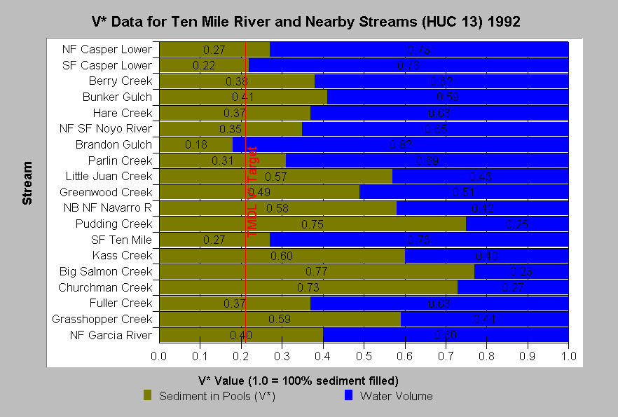 Knopp (1993) used V* techniques to measure sediment in pools in two locations within the Ten Mile River basin as well as other nearby streams. Those streams with a high proportion of pool volume filled with sediment are likely to be impaired with regard to coho salmon juvenile production. Churchman Creek, a South Fork Ten Mile River tributary, had a V* value of 0.73, near the upper limit of values measured at any north coast location. The mainstem South Fork Ten Mile had moderate levels of sediment in pools (0.27) as of 1992. This measurement was taken after five years of drought and was taken too early to fully reflect sediment yield from timber harvests in the 1990-1999 era. The Ten Mile River TMDL threshold of 0.21 is shown for reference (US EPA, 2000).
Alternative Hypothesis
Fine sediment in the Ten Mile River basin is near normal background levels.
This hypothesis has been advanced in Hines (2000), Valentine and Jameson (1994) and the Pacific Lumber Company Freshwater Creek Watershed Analysis Fisheries Module (PALCO, in review). Results from Burns (1972) have been offered as support for this alternate hypothesis under the assumption that conditions sampled in that study are representative of "background" sediment levels. However, the Burns (1972) study followed the first cycle of logging and can only be indicative of post disturbance levels. A speculative argument in support of the hypothesis reasons that the erosive geology of the region would have caused high levels of sediment prior to anthropogenic erosion.
Monitoring Trends to Support or Refute the Hypothesis
A monitoring program to test the relationships between sediment, habitat and coho salmon production would periodically measure pool habitat availability, pool depth, and sediment in pools (V*). Gravel composition (McNeils) and/or permeability and coho standing crop should be measured annually. Trends in coho numbers or biomass would be compared to trends in sediment and habitat metrics. If biomass or numbers of coho salmon juveniles increase when pool depth increases and/or when fines in the substrate decreases, this would support the hypothesis. Confounding factors such as high water temperature, varying levels of large wood or cover would need to be considered. Hypothesis-based monitoring could be part of TMDL implementation: 1) implement erosion control measures, 2) monitor sediment and fish populations, 3) test hypothesis by analyzing relative trends, and 4) evaluate effectiveness of measures.
References
Ambrose, J., D. Hines, D. Hines, D. Lundby, and J. Drew. 1996. Ten Mile River Watershed 1995 Instream Monitoring Results. Volume I. Georgia-Pacific West Inc. Fort Bragg, CA. 84 pp.
Ambrose, J., and D. Hines. 1997. Ten Mile River Watershed 1996 Instream Monitoring Results. Georgia-Pacific West Inc. Fort Bragg, CA. 55 pp.
Ambrose, J., and D. Hines. 1998. Ten Mile River Watershed 1997 Instream Monitoring Results. Georgia-Pacific West Inc. dba The Timber Company. Fort Bragg, CA. 51 pp.
Barnard, 1992. Physical and Chemical Conditions in Coho Salmon (Oncorhynchus kisutch) Spawning Habitat in Freshwater Creek, Northern California. Masters Thesis. Humboldt State University, Arcata, CA. 81 p. plus appendices.
Beschta, R.L. and W.L. Jackson. 1979. The intrusion of fine sediments into a stable gravel bed. Journal of the Fisheries Research Board of Canada 36:204-210.
Brown, L.R., P.B. Moyle and R.M.Yoshiyama, 1994. Historical Decline and Current Status of Coho Salmon in California. North American Journal of Fisheries Management. 14( 2) 237-261.
Burns, J. 1972. Some Effects of Logging and Associated Road Construction on Northern California Streams. Transactions of the American Fisheries Society, Vol. 101, No. 1: 1-17.
California Department of Fish and Game. 1998. California Salmonid Stream Habitat Restoration Manual. Third Edition. Inland Fisheries Division. California Department of Fish and Game. Sacramento, CA. 495 p.
Chapman. D.W. 1988. Critical Review of Variables Used to Define Effects of Fines in Redds of Large Salmonids. Transactions of the American Fisheries Society. 117: 1-21.
Hines, D. 2001. 1999 Ten Mile River Sediment Monitoring Report. Campbell Timberland Mgt, Inc. Fort Bragg, CA. 10 pp.
Knopp, C. 1993. Testing Indices of Cold Water Fish Habitat. Final Report for Development of Techniques for Measuring Beneficial Use Protection. North Coast Region Water Quality Control Board in cooperation with California Department of Forestry. 57 pp.
Kondolf, G.M. 2000. Assessing Salmonid Spawning Gravel Quality. Trans. Am. Fish. Soc. 129:262-281.
Manning, D.J. 2000. Carrying Capacity and Limiting Habitat Analysis for Coho Salmon (Oncorhynchus kisutch) in Streams of Northwestern California. Masters Thesis, Humboldt State University, Arcata, CA. 111p.
McHenry, M.L., D.C. Morrill and E. Currence. 1994 . Spawning Gravel Quality, Watershed Characteristics and Early Life History Survival of Coho Salmon and Steelhead in Five North Olympic Peninsula Watersheds. Lower Elwha S'Klallam Tribe, Port Angeles, WA. and Makah Tribe, Neah Bay, WA. Funded by Washington State Dept. of Ecology (205J grant).
McNeil, W. J. and W.H. Ahnell. 1964.Success of Pink Spawning Relative to Size of Spawning Bed Material. U.S. Fish and Wildlife Service, Special Scientific Report-Fisheries No. 469. Washington, D.C. 17 pp.
Murphy, M.L., J.F. Thedinga, K.V. Koski and G.B. Grette. 1984. A stream ecosystem in an old growth forest in southeast Alaska: Part V. Seasonal changes in habitat utilization by juvenile salmonids. In Proceedings of Symposium on Fish and Wildlife in Relationships in Old Growth Forests. Eds. W.R. Meehan, T.R. Merrill and T.A. Hanley. Amerian Institute of Fishery Research Biologists, Asheville, North Carolina.
North Coast Regional Water Quality Control Board. 1998 . Garcia River Total Maximum Daily Load for Sediment. US EPA Region 9, San Francisco, CA. 87 p.
Pacific Lumber Company. In review. Fisheries Module of the Freshwater Watershed Analysis. Appendix F, Freshwater Creek Watershed Analysis. Released for review March 2001. Performed under contract to PALCO by NRM, Eureka and Entrex, Oakland, CA. 95 pp.
Pacific Watershed Associates. 1999. Sediment Source Investigation and Sediment Reduction Plan for the Freshwater Creek Watershed, Humboldt County, California. Performed under contract to the Pacific Lumber Company. PWA, Arcata, CA. 94 p.
Valentine, B.E. and M. Jameson. 1994. Little North Fork Noyo Fishery Study, 1992. CA Department of Forestry and Fire Protection, Coast Cascade Region. Santa Rosa, CA. 48 pp.
U.S. Environmental Protection Agency. 2000. Ten Mile River, Total Maximum Daily Load for Sediment. Region IX. San Francisco, CA. 89 pp. Summary and Responses. 18 pp.