 |
 |
| Background | Hypotheses | Bibliography | Maps | Home |
| |
|
| Background | Hypotheses | Bibliography | Maps | Home |
KRIS Web Background Pages: Habitat Types
![]()
The KRIS Ten Mile CD contains habitat typing data from surveys conducted by Georgia Pacific in 1995-1996 and shared by Hawthorne Timber Company in the form of data and reports. Reports can be accessed in the KRIS Bibliography. KRIS charts summarize habitat frequency-by-length, pool depth, embeddedness, and canopy closure as indicators of salmonid habitat conditions and cumulative effects to stream channels. In addition, percent scour pools and large wood-formed pools are charted similar to the analysis of Ten Mile River Basin habitat data in CRWQCB (2001).
In KRIS Ten Mile, charts summarize results from each surveyed stream in either the entire basin or a subbasin. This presentation facilitates comparison of conditions among streams, and is less redundant than charts for individual streams. Because some of the habitat measurements involve subjectivity, comparison of habitat survey data among streams may be confounded by different field staff and seasons of survey. Fortunately, the Ten Mile River Basin surveys were fortunately conducted by the same staff during the same two-year period. Still, comparison of habitat conditions among streams should try to account for the role of flow, stream size, slope, and channel type. KRIS habitat charts order streams by stream size. Available information on these other factors can be found in the Chart Table.
Pool Frequency, Pool Depth and Pool Type
Habitat typing results are simplified for presentation in KRIS charts by showing four comprehensive habitat categories: pools, riffles, flat water habitats and dry areas. Habitat frequency by length is used instead of percent occurrence because it is a better index of cumulative effects. When substantial erosion occurs in a watershed, streams typically aggrade and pool habitats fill in (Madej, 1984). Subsequent habitat surveys will find less pool habitat, and more shallow riffles and flatwater habitats. Such streams may still be suitable for young of the year steelhead, but young coho salmon and older steelhead trout require deeper pools, preferably with large wood. Brown et al. (1994) suggested that pools of one meter in depth or greater were necessary for successful rearing of coho salmon juveniles. Chen (1992) based cumulative effects models for the Elk River, Oregon on whether three foot deep pools were being maintained.
|
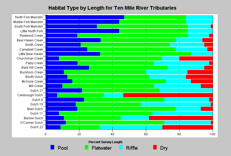
This chart shows pool habitat availability, or the proportion of surveyed lengths of Ten Mile River tributaries occurring as pool habitat. Pool habitat by percent length (blue bars) ranged from 8% (Cavanough Gulch) to 47% (North Fork). The chart also illustrates the percentage of linear habitat that had gone subsurface (red bars) during the time of survey which varied from June to August. According to CDFG benchmarks for percent pool habitat, most tributaries of the Ten Mile River provide poor habitat (<25%), and no streams provide good habitat (>50%). |
|
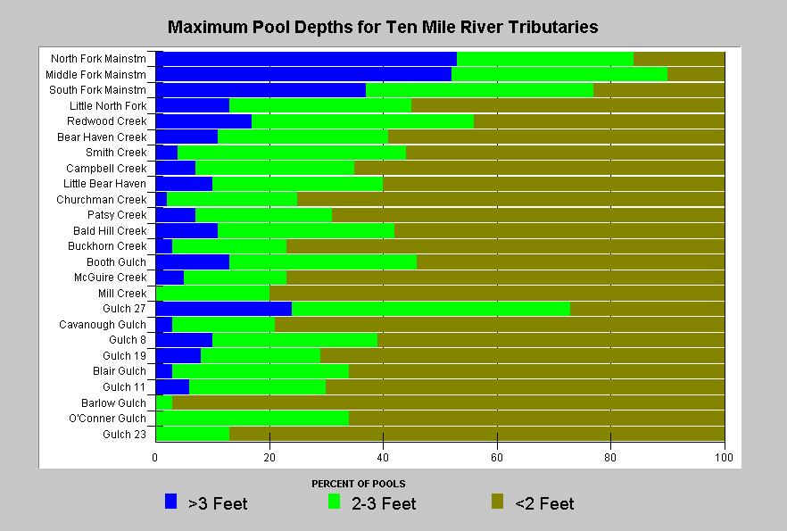
This chart shows that pools deeper than 3 feet are rare in the Ten Mile River Basin, outside the larger channels of the North Fork, Middle Fork (Clark Fork), and South Fork. Lack of pool depth is likely limiting production of juvenile coho salmon. |
|
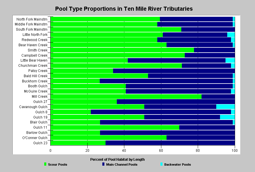
This shows the relative proportions of scour pools, main channel pools, and backwater pools classified during habitat typing surveys of the Ten Mile River. Scour pools and backwater pools are associated with stream channel complexity and processes that create and maintain good fish habitat. Scour pool frequency varied from 22% (Gulch 8) to 82%(Mill Creek), and backwater pool frequency varied from 0% (ten streams) to 10% (Cavanough Gulch). |
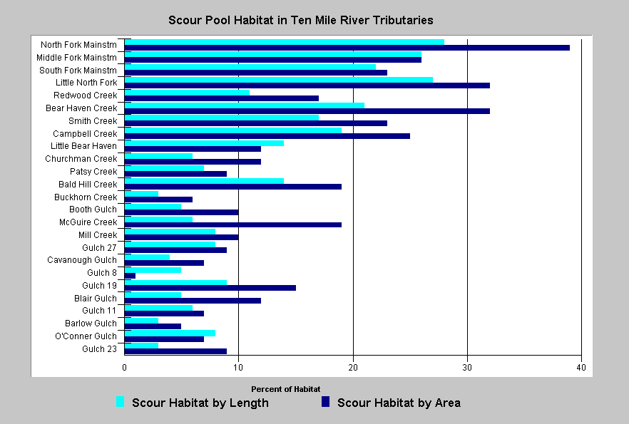 |
This chart shows the percent of habitat area formed by scour or large wood for all surveyed Ten Mile River Basin streams. Large wood formed habitat is included in the scour formed habitat value. Streams are ranked by the percent of habitat formed by large wood. Based on analysis of where coho salmon have persisted, the CRWQCB (2001) has suggested that less than 8% large wood formed is representative of habitat too poor to support coho rearing. |
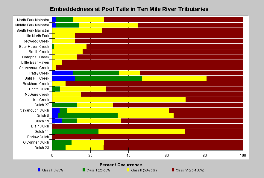
Embeddedness
Pool tail embeddedness is a simple but subjective means of evaluating salmonid spawning habitat quality in the field. Pools tail crests are measured visually to determine to what degree potential spawning gravels might be embedded (partially buried). The California Department of Fish and Game (1998) categorize gravels less than 25% embedded as optimal for salmonid spawning. Other categories are 25-50%, 50-75% and greater than 75%. A fifth category is used to describe pool tails otherwise unsuitable for spawning (log, plank, rock, concrete sill, bedrock sheet, etc.). High embeddedness is generally caused by an excessive supply of sediment to the stream. Embeddedness estimates are visual and involve some subjectivity. The method is somewhat reliable for showing differences in habitat conditions among streams surveyed by the same observers, and much less reliable for strictly classifying habitat conditions or showing differences among streams surveyed by different observers. By contrast, bulk gravel (McNeil) or permeability samples are much more rigorous in describing spawning and incubation habitat conditions (see Sediment Background page).
|
All but five of the surveyed streams in the Ten Mile River basin had more than 50% of pool tails at the highest levels of embeddedness. Only Bald Hill Creek and three other North Fork tributaries had more than 20% of pool tails at lower levels of embeddedness (1 or 2). A rating of 2 indicates spawning habitat where cobbles are buried in fine sediment 25-50%, and a rating of 4 indicates 75-100% embeddedness. |
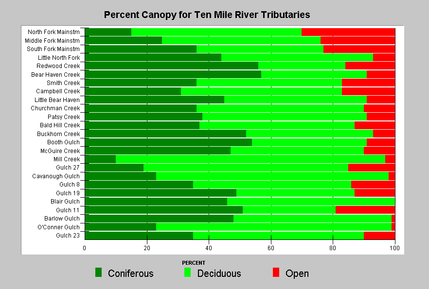
Canopy Cover
Canopy is an indicator of whether there is direct shade on a stream. Surveyors measure canopy from the middle of the stream using a densiometer (CDFG, 1998). The California Department of Fish and Game (1998) recognizes that "stream canopy should be approximately 80 percent to maintain suitable water temperatures" for salmonids, but that optimal canopy conditions may involve less total canopy in fourth order and large streams.
Shade is important for keeping streams cool, but it is less important than air temperature in determining stream temperature. Air temperature over the stream can be modulated by topography and vegetation that maintains a microclimate (see Temperature Background page). Large coniferous trees are particularly effective at maintaining microclimate, and microclimate may be negatively effected, even if shade is maintained, by harvest of large overstory trees back from the immediate stream edge (see Riparian Background page). Small diameter conifers and hardwoods also provide a very low quality and longevity of wood for aquatic habitat diversity (Cedarholm et al., 1996).
|
The percentage of coniferous canopy varied greatly among streams of the Ten Mile River basin according to habitat typing data. Only Buckhorn Creek, Bear Haven Creek, and Booth Gulch had coniferous canopies greater than 50%. Overall canopy cover exceeded 80% in all but mainstem stream segments, but deciduous trees comprised a large component. |
![]()
References
Brown, L.R., P.B. Moyle, and R.M. Yoshiyama. 1994. Historical Decline and Current Status of Coho Salmon in California. North American Journal of Fisheries Management. 14(2):237-261.
Byrne, M. 1997. California Salmonid Habitat Inventory: a Dynamic Segmentation Application. Earth Science Research Institute (ESRI), 1997 Annual Proceedings of ESRI Conference. CDFG, Inland Fisheries, Sacramento, CA.
CA Department of Fish and Game. 1998. California Salmonid Stream Habitat Restoration Manual. Third Edition. Inland Fisheries Division. California Department of Fish and Game. Sacramento, CA. 495 p.
California Regional Water Quality Control Board (CRWQCB). 2001. Assessment of aquatic conditions in the Mendocino coast hydrologic unit. North Coast Region, CRWQCB. Santa Rosa, CA. 284 pp. [947k]
Chen,G. 1992. Use of Basin Survey Data in Habitat Modeling and Cumulative Watershed Effects Analysis. Siskiyou NF. Published as part of USDA Forest Service Region 5 Fish Habitat Relationship Technical Bulletin Series, No. 8.
Georgia-Pacific Co. 1996. Habitat typing inventory reports: Ten Mile River Watershed. Surveys conducted during 1994/95. Unpublished file memo. Fort Bragg, CA. 103 pp.
Madej, M. 1984. Recent changes in channel-stored sediment Redwood Creek, California. Redwood National Park Technical Report #11, Arcata, CA. 54 p.
Poole, G.C., and C.H. Berman. 2000. Pathways of Human Influence on Water Temperature Dynamics in Stream Channels. U.S. Environmental Protection Agency, Region 10. Seattle, WA. 20 p.
![]()
| www.krisweb.com |