 |
 |
| Background | Hypotheses | Bibliography | Maps | Home |
| |
|
| Background | Hypotheses | Bibliography | Maps | Home |
KRIS Web Background Pages: Sediment
![]()
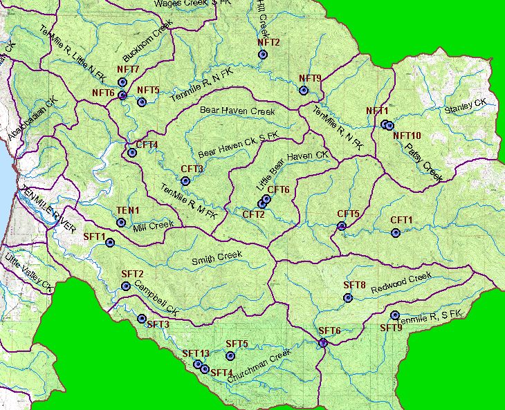
The main source of sediment data in KRIS Ten Mile is the Hawthorne Timber Company (Ambrose et al., 1996; Ambrose and Hines, 1997; Ambrose and Hines, 1998; Hines, 1999). Hawthorne Timber Company (HTC) acquired holdings of Georgia Pacific (GP) Corporation in 1999, so several of the studies cited herein were actually conducted under the former ownership. GP and HTC have monitored fine sediment at 46 riffles in 23 streams since 1993 (see Map). Sediment is collected using a grab sampler, also known as a McNeil core and wet sieved on site. Data was acquired for KRIS Ten Mile in raw form as Excel spreadsheets but interpretation of the data is also provided by company biologists in the reports cited above and available in the KRIS Bibliography.
The Ten Mile River basin is listed as impaired with regard to sediment under the Clean Water Act and the Ten Mile River TMDL for Sediment (U.S. EPA, 2000). The TMDL study (U.S. EPA) states that: "Sediment was determined to be impacting the cold water fishery, a beneficial use of the Ten Mile River watershed, including the migration, spawning, reproduction, and early development of cold water fish such as coho salmon and steelhead trout. Cold freshwater and estuarine habitats are also designated beneficial uses of the Ten Mile River watershed."
References shown in KRIS Ten Mile for sediment less than 0.85 mm are based on targets put forth in the Ten Mile River TMDL (U.S. EPA, 2000) and from Kondolf (2000) for sediment less than 6.4 mm. The value for the smaller sediment size class appears reasonable given existing information both locally and regionally. For example, the 14% threshold for fines (<0.85 mm) is conservative relative to the National Marine Fisheries Service (1996) guidelines for properly functioning salmon habitat, which set a limit of 12% fine sediment less than 0.85 mm. McHenry et al. (1994) found that fines less than 0.85 mm were nearly 100% lethal to coho and steelhead eggs when they exceeded 13% within the redd. Kondolf (2000) reviewed 5 studies reporting <0.85 mm fine sediment percentages corresponding to 50% emergence of salmonids and reported 14% as a mean value. Barnard (1992) used freeze core sampling in Freshwater Creek, a Humboldt Bay tributary, and found that sediment less than 1 mm comprised less than 10% of the samples at most sites. Fine sediment levels (<1 mm) inside redds averaged 7.5% and outside redds averaged 13.1%. The bedrock geology from Freshwater Creek is sandstone and Franciscan, and the watershed had experienced 40-60 years of rest. Hines (2001) argues that 20% fine sediment (<0.85 mm) is a more "reasonable" target, but this target is being met in the South Fork Ten Mile yet coho are decreasing (see Hypothesis #3 for further discussion).
The Garcia TMDL (USEPA, 1998) set a target of 30% for sand-sized fine sediment (<6.4 mm). This reference value is plotted on KRIS charts and supported by Kondolf (2000) who reviewed 10 studies reporting <6.4 mm fine sediment percentages corresponding to 50% survival to emergence for salmonids and found 30% as a mean value. The sieve sizes used by Hawthorne Timber Company spanned the 6.4 mm class size, so a simple linear interpolation of the 6.4 mm size class was performed from the 4 and 8 mm size classes (Bunte and Apt 2001).
 |
Click on image at left to view Table 1 from the Ten Mile River, Total Maximum Daily Load for Sediment (U.S. EPA, 2000) which puts forth targets that are used for sediment analysis in KRIS Ten Mile. |
Sediment topics in KRIS Ten Mile show bars representing the average of four McNeil cores at a station (riffle) and whiskers representing standard deviation. Because the sample size at each station was four, whiskers also represent 95% confidence intervals around the mean. Examples are given below. Data were provided by Hawthorne Timber Company.
 |
McNeil sample results for fines less than 0.85mm from Middle Fork Ten Mile River (CFT2) are displayed at left for the years of record: 1993 to 2000. While it is difficult to determine trends from only eight years of data, this site does show significant variation in fine sediment over time. An increase was measured in 1994 and followed by a decrease to significantly lower levels in 1998. The pattern and hydrologic record suggest that the sustained wet period of 1995-1998 resulted in a net flushing of the fines downstream before more was introduced in 1999. |
 |
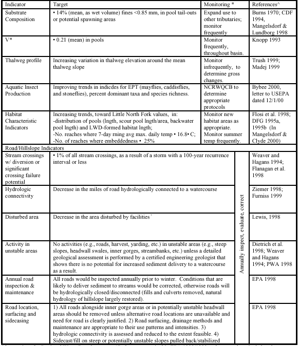
McNeil sample results for fines less than 0.85mm from Lower Campbell Creek (SFT2) are displayed at left for the years 1993 to 2001. Fine sediment (<0.85 mm) was over levels recognized as optimal for salmonids in most years, and most significantly over the TMDL threshold in recent years. A similar but less dramatic pattern is evident from the data for Churchman Creek and Smith Creek, other tributaries of the South Fork Ten Mile River. |
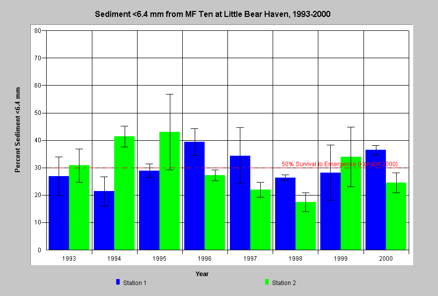 |
This chart shows percent fine sediment less than 6.4mm from Middle Fork Ten Mile River (CFT2) in the years 1993 to 2000. Pattern in these data closely resemble results for percent fine sediment < 0.85mm (shown above for the same site) because these results are largely comprised of the finest particle fraction. The broader size category is less susceptible to seasonal fluctuation. High percentages of sand and pebbles between 0.85 mm and 6.4 mm decrease egg survival and inhibit the emergence of fry. |
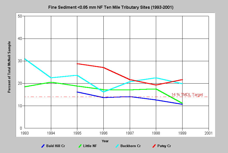 |
Average percent fine sediment less than 0.85 mm from McNeil samples in North Fork Ten Mile tributary monitoring sites are displayed at left. This type of chart is presented for consideration of trends over time. The values plotted are the average of all eight samples from two riffles each year. Data in this chart suggest decreasing levels of fine sediment in four North Fork Ten Mile tributary locations. |
Data from Knopp (1993) also appear in KRIS Ten Mile. Knopp (1993) measured various stream habitat parameters at 60 stream locations throughout northwestern California, including Churchman Creek and the South Fork Ten Mile River. Knopp found significant linkage between sediment in pools, particle size distribution and watershed disturbance.
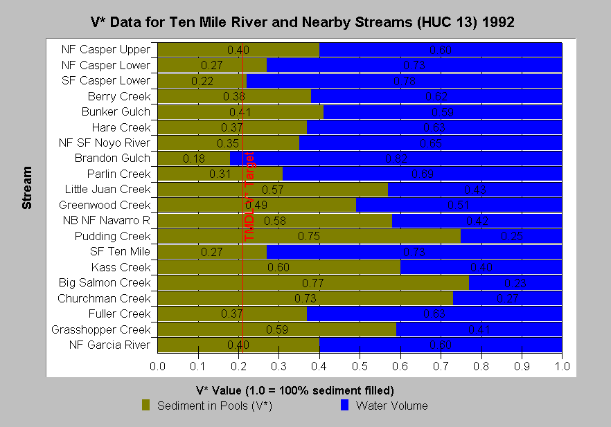 |
Values from Knopp (1993) are shown at left for V* in decimal percent. A value of 0.5 represents that half of the pool is filled with fine sediment. The TMDL limit of 0.21 was adopted for the Ten Mile River and is shown as a threshold on the chart.. Knopp (1993) found that intensity of watershed management and timber harvest were reflected in V* values. While the South Fork Ten Mile had a moderate V* value of 0.27 when measured in 1992, Churchman Creek was 0.73, a very high value. |
KRIS Ten Mile draws heavily on the Sediment Source Analysis and Preliminary Sediment Budget for the Ten Mile River (Matthews, 2000) for data and analysis regarding sediment sources, sediment yield by period and sediment transport. Other data provided by Matthews (2000) are used in Topics and background pages related to roads and timber harvest. This report was produced to supply supporting information to the Ten Mile TMDL report (U.S. EPA, 2000). All data in the following charts are from Matthews (2000).
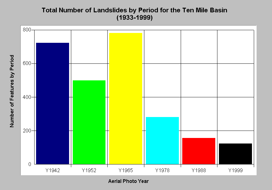 |
The chart at left shows the type of landslide and the period of initiation for the Ten Mile River basin. The landslides were mapped from aerial photos and the photo years are on the X-axis. The first period is estimated to cover features spanning back to 1933 and the other periods are those bracketed by the photo years. Debris slides were the most common feature. Far fewer landslides have occurred in recent periods with the highest sediment yield shown in 1965 following the 1955 and 1964 floods. |
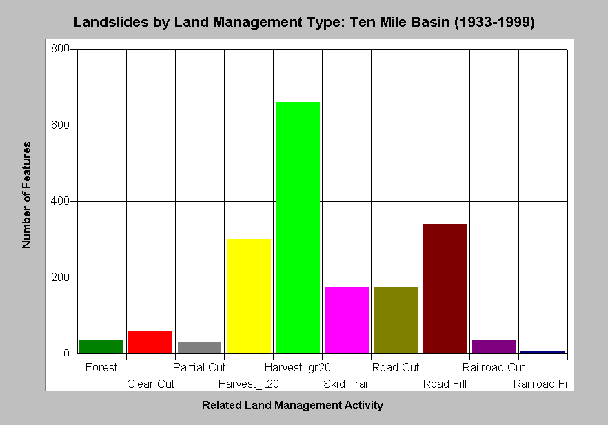 |
The chart at left shows the antecedent land management associated with landslides identified from aerial photographs in the Ten Mile River basin. Data are derived from aerial photographs from 1942, 1952, 1965, 1978, 1988 and 1999. Only 36 landslides occurred in undisturbed forest lands (Forest). The highest number of slides (660) occurred more than 20 years after timber harvest (Harvest_gr20) but a substantial number (300) also happened on slopes cut less than 20 years ago (Harvest_lt20). Road fills caused 340 debris slides, some of which were crossings that failed during major storm events. Railroads triggered 37 landslides. |
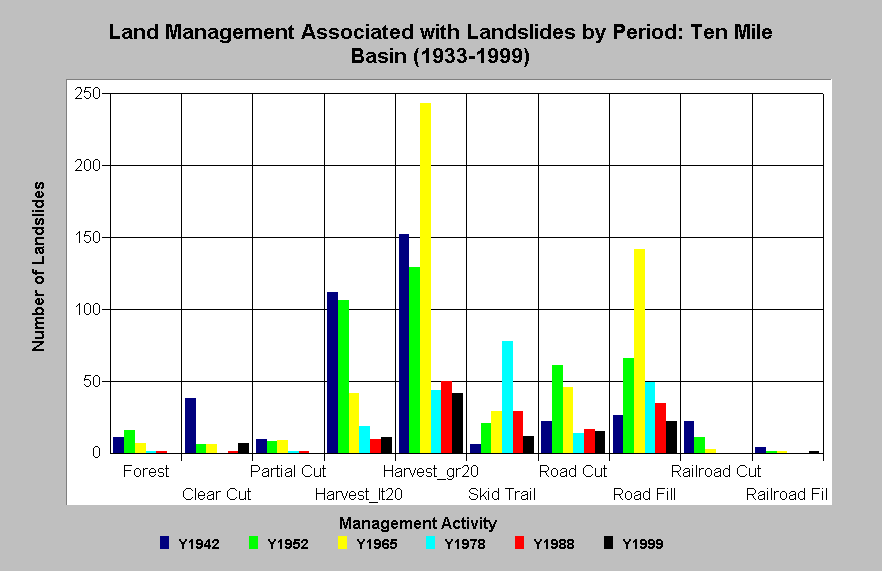 |
The chart at left shows the association of land management practices to landslides by period for the Ten Mile River basin. The slides were mapped from aerial photos and the photo years are color coded. The first period is estimated to cover features spanning back to 1933 and the other periods are those bracketed by the photo years. Far fewer landslides have occurred in recent periods. |
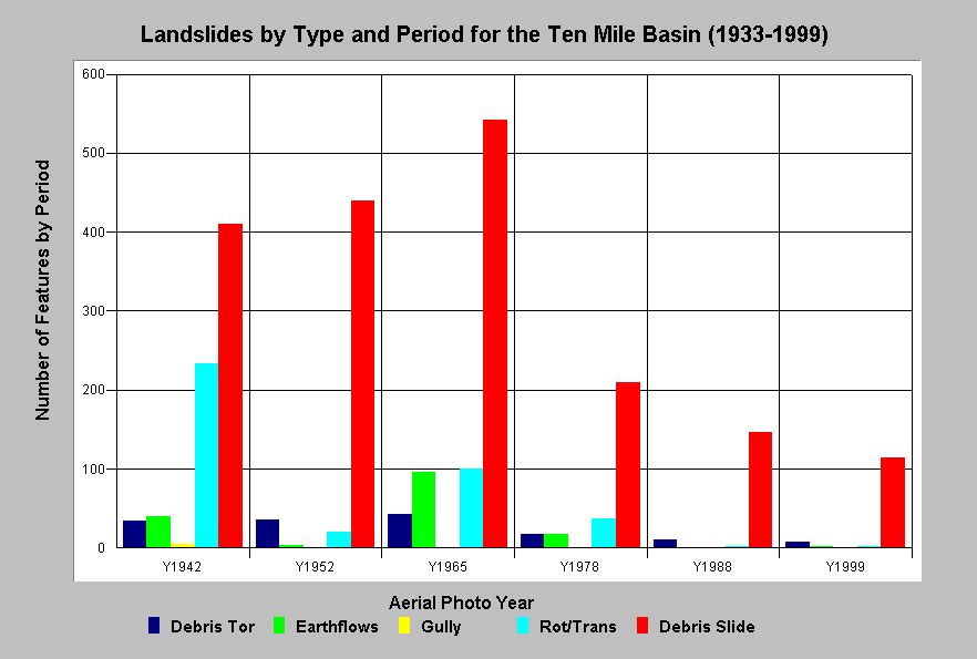 |
The chart at left shows the type of landslide and the period of initiation for the Ten Mile River basin. It is patterned after treatments in from Matthews (2000). The slides were mapped from aerial photos and the photo years are on the X-axis. The first period is estimated to cover features spanning back to 1933 and the other periods are those bracketed by the photo years. Debris slides were the most common landslide feature. Far fewer landslides have occurred in recent periods. |
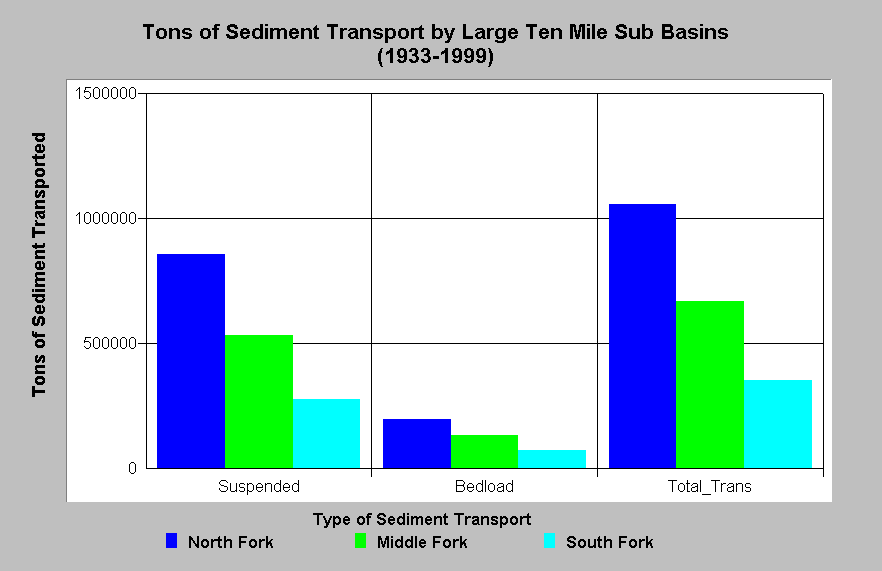 |
The chart at left shows the amount of sediment transport in tons per acre for three large Ten Mile River sub-basin areas. The variables shown on the X-axis are suspended sediment transport, bedload transport and total transport in both forms. The highest sediment transport has come from the North Fork sub-basin followed by the Middle Fork. Sediment transport is a function of stream power (gradient) as well as supply. |
Habitat typing data can also be used to analyze sediment impacts on habitat. For example, high sediment yield reduces pool frequency and depth. See Habitat Typing: What's in KRIS Ten Mile page for further discussions.
![]()
References
Barnard, 1992. Physical and Chemical Conditions in Coho Salmon (Oncorhynchus kisutch) Spawning Habitat in Freshwater Creek, Northern California. Masters Thesis. Humboldt State University, Arcata, CA. 81 p. plus appendices.
Hines, D. 2001. 1999 Ten Mile River Sediment Monitoring Report. Campbell Timberland Mgt, Inc. Fort Bragg, CA. 10 pp
Knopp, C. 1993. Testing Indices of Cold Water Fish Habitat. North Coast Regional water Quality Control Board, Santa Rosa, CA. Cooperatively sponsored by the USDA Forest Service.
Kondolf, M. G. 2000. Assessing Salmonid Spawning Gravel Quality. Transactions of the American Fisheries Society 129:262-281.
Matthews, Graham and Associates. 2000a. Sediment source analysis and preliminary sediment budget for the Ten Mile River, Mendocino County, CA. Prepared for Tetra Tech, Inc. VOLUME 1: Text, Tables, and Figures. Fairfax, VA. 143 pp.
Matthews, Graham and Associates. 2000b. Sediment source analysis and preliminary sediment budget for the Ten Mile River, Mendocino County, CA. Prepared for Tetra Tech, Inc. VOLUME 2: Appendices. Fairfax, VA. 59 pp.
McHenry, M.L., D.C. Morrill, and E. Currence. 1994 . Spawning Gravel Quality, Watershed Characteristics and Early Life History Survival of Coho Salmon and Steelhead in Five North Olympic Peninsula Watersheds. Port Angeles, WA. 59 pp. without appendices.
National Marine Fisheries Service. 1996. (Table 1 from...) Coastal Salmon Conservation: Working Guidance for Comprehensive Salmon Restoration Initiatives on the Pacific Coast. US Dept. Commer, NOAA. 4 pp.
US Environmental Protection Agency (USEPA). 1998. (Final) Garcia River Sediment Total Maximum Daily Load. Dated 16 March 1998. USEPA, Region IX. San Francisco, CA. 51 pp.
U.S. Environmental Protection Agency. 2000. Ten Mile River, Total Maximum Daily Load for Sediment. Region IX. San Francisco, CA. 89 pp. Summary and Responses. 18 pp.
![]()
| www.krisweb.com |