 |
Battle Creek Overview | Bibliography | Home | |
![]()
Terraqua (2004) assessed channel width-to-depth ratios, channel types, large wood availability, pool frequency and pool depth as part of the Battle Creek Watershed Assessment (WA). Results for channel cross sectional profiles are shown below. The U.S. Forest Service (Napper, 2001) noted channel changes in the upper South Fork Battle Creek watershed and that study is linked below as a reference for further reading..
|
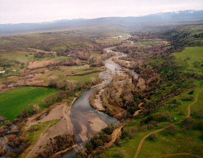
Tan colored
terraces and mid-channel bars appear in this aerial photo of lower Battle
Creek taken just after the January 1997 storm. These features are sediment
deposits which are also causing the channel to braid. Photo taken by Harry
Rectinwald, CDFG. From KRIS Battle Creek V 1.0. April 1997.
|
Findings of Battle Creek Watershed Assessment
Terraqua (2004) measured channel transects in accordance with Rosgen (1996) as one indicator of aquatic health. The Battle WA findings for channel profiles were as follows:
"Significant stream avulsions and/or overflow channels were noted during field surveys at 12 of 49 sites. At these sites, multiple bankfull channels were separated by land higher than the bankfull elevation in at least one or more survey transects. Most of the disturbance at these sites appeared to be the result of recent flooding, probably the result of a large flood in January 1997. The two lowermost sites (sites #032 and #046) and a mid-elevation site located in a meadow (site #029), had multiple channels typical of low-gradient Rosgen D-type reaches and showed no apparent flood effects. Most sites with multiple channels were located at elevations above the dominant rain-on-snow zone (Figure 14) and also showed signs of significant bank erosion. Three mid-elevation sites with multiple channels, particularly site #057 on North Fork Battle Creek, did not show significant erosive effects of flooding (e.g., no significant bank erosion) but did show signs of bedload aggradation that forced the stream to carve multiple channels at higher flow."
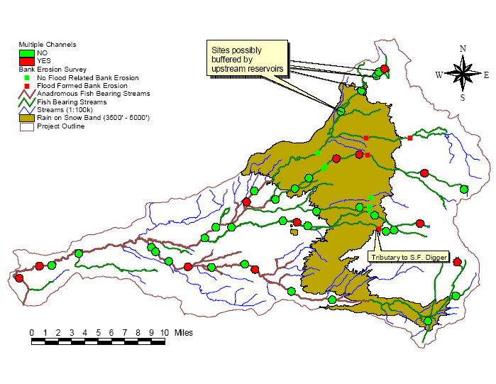 |
Figure 1. In this Battle Creek WA map stream reaches with multiple channels are shown in red, and those with single channels and no aggradation shown are in green. The back drop shows the rain-on-snow region of Battle Creek (3500'-5000'). Terraqua (2004) notes that sites on upper North Fork Battle would likely be buffered from upstream cumulative watershed effects by the North Fork Battle Creek Reservoir. |
The Battle Creek WA describes "sediment waves" that might be passing through the watershed, citing corollary information regarding channel changes such as streamside alder mortality on the middle North Fork:
"Evidence for such a wave of bedload was directly observed in an approximately 1,100 meter long reach extending from Site #057 (in the middle reaches of North Fork at about 2,300 elev.) downstream to near the confluence with Bailey Creek. Within this reach, perhaps one to two feet of aggraded gravel to cobble sized material (the D50 at Site #057 was 356 mm) spanned the width of the stream channel and buried the trunks of mature alders closest to the stream. The wetted stream channel and bankfull channel was higher than it would have been at the time of alder colonization because of general aggradation of the stream channel: many mature alders were within the wetted width and the recent bankfull width indicators were found bank-side of mature alders in many places. We estimated that this sediment aggradation was no older than three to five years because many mature alders were still alive while the dead trees had not been dead for long. Channel avulsions at Site #057 were also considered to be indicators of an unstable stream channel at this site."
Terraqua (2004) used statistical power analysis to check for relationships between channel morphology and upland conditions and sediment sources but found none.
![]()
|
Related
Pages
|
|
| Battle Creek Overview | KRIS General Background |
![]()
References
Armentrout, S., H. Brown, S. Chappell, M. Everett-Brown, J. Fites, J. Forbes, M. McFarland, J. Riley, K. Roby, A. Villalovos, R. Walden, D. Watts, and M.R. Williams, 1998. Watershed Analysis for Mill, Deer, and Antelope Creeks. U.S. Department of Agriculture. Lassen National Forest. Almanor Ranger District. Chester, CA. 299 pp. [6.0 Mb]
Napper, C. O., 2001. Cumulative Watershed Effects - Battle Creek. Analysis of beneficial uses and water quality criteria to evaluate CWE susceptibility. U.S. Department of Agriculture, Forest Service, Lassen National Forest . Susanville, CA. 22 pp. [92 kb] .
Rosgen, D. 1996. Applied River Morphology. Wildland Hydrology, Pagosa Spring, Colorado.
Terraqua, Inc. 2004. Battle Creek Watershed Assessment :Characterization of stream conditions and an investigation of sediment source factors in 2001 and 2002. Performed under contract to the Battle Creek Watershed Conservancy, Manton, CA. Funds from the Anadromous Fisheries Restoration Program and U.S. Fish and Wildlife Service under Agreement DCN: 11330-1-J113.
![]()
| www.krisweb.com |