 |
Battle Creek Overview | Bibliography | Home | |
|
Battle Creek Overview | Bibliography | Home | |
![]()
The Battle Creek Watershed Assessment (Terraqua, 2004) was conducted in part to determine sediment sources, but also to collect aquatic baseline data and to set up monitoring for adaptive management. Among other factors, they looked at surface fine sediment in pool tail crests and median particle size distribution (D50) at 50 sites throughout the Battle Creek watershed and their findings are summarized below.
The U.S. Forest Service's Watershed Analysis for Deer, Mill and Antelope Creeks (Armentrout et al., 1998) set a target of 10% surface fine sediment less than 2 mm at pool tail crests in mainstem segments of these streams, which are adjacent to Battle Creek. Smaller tributaries were expected to have less than 15% fines (<2 mm) in watersheds without rhyolitic soils and less than 20% in tributaries flowing from rhyolitic basins. They measured surface fines in Mill and Deer Creek mainstem locations and found them to be less than 7% on average, with 19 and 42 sites surveyed in each creek, respectively.
A California Department of Fish and Game study of sediment in Mill Creek (Cordone and Kelly, 1961) noted problems as a result of the 1955 flood: "The shifting of the channel and the eroding and smothering action of silt and sand apparently caused a complete kill of the developing young salmon." Gangmark and Bakkala (1960) created a silt-free side channel to Mill Creek as an experiment to gauge survival of spring chinook salmon eggs versus the natural channel. They found mortality of salmon eggs in Mill Creek itself was 98.3%, which they attributed to "reduced seepage in the gravel" due to high fine sediment supply. While survival of eggs in side channels was greater, and not effected by bedload shift, fines carried by high flows infiltrated the redds and caused egg mortality.
Findings of Battle Creek Watershed Assessment
Terraqua (2004) followed U.S. Forest Service Aquatic and Riparian Effectiveness Monitoring Program (AREMP) methods, as described by Gallo (2002), for measuring surface fine sediment and median particle size distribution. An exception in the study is fine sediment samples were not taken at several location because the stream bottom was covered with algae. Data interpretation in the Battle Creek WA followed rating curves for salmonid suitability as used in the Ecosystem Management Decision Support (EMDS) model (Reynolds, 2001).
Surface Fines: Surface fine sediment less than 2 mm at pool tail crests was measured at 35 of 50 sites as a result of algae at 7 sites and lack of scour pools at 8 sites. Surface fine sediment is easy to measure yet the location in pool tail crests gives an indication of accumulation of sediment in areas that would be chosen by salmonids for spawning. With regard to surface fine sediment, the Battle Creek WA found:
"Among all sampled sites, the mean percent fine sediment was 31 percent, while percent fine sediment at individual sites ranged from 4 to 85 percent. Mean percent fine sediment was significantly greater in response versus transport reaches.
EMDS analysis of percent fine sediment indicates, with reasonable or high certainty, that fine sediment conditions at 8 of 35 sites were fully or likely favorable for salmonid production while fine sediment conditions at 22 sites rated as fully or likely unfavorable.
Sites with favorable levels of fine sediment were distributed throughout the watershed and were not clustered in any particular portion of the watershed. Likewise, sites with unfavorable fine sediment levels were also not particularly clustered in any one portion of the watershed."
Fine sediment measurements....appeared to be affected by processes active during the low flow period in addition to sediment delivery processes that are primarily active at higher flows."
The Battle Creek WA found no relationship of surface fine sediment to upland factors using a power analysis. The analysis of surface fines was run against factors such as elevation and watershed area, road density, near-stream road density, road-stream crossing frequency, rain-on-snow area, rhyolite soil, near-stream meadow area and forest cover. "In other words, variability in none of the sediment source factors, with the exception of stream gradient, was statistically related to observed fine sediment in the Battle Creek watershed" (Terraqua, 2004).
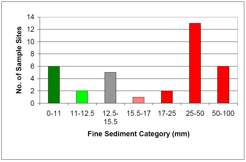 |
This chart from the Battle Creek WA, displays the results of surface fine sediment measurements in 2001-2002. The frequency histogram shows the number of sites with varying amounts of surface fines, with colors of bars related to the EMDS suitability for salmonids. Fines less than 11% are fully suitable (dark green), 11-15.5% somewhat suitable (light green/grey), 15.5-17% somewhat unsuitable (pink) and over 17% fully unsuitable (red). The majority of sites measured in Battle Creek have fine sediment levels found by EMDS criteria to be fully unsuitable for salmonids. This is from Figure 5 in the Battle Creek WA. |
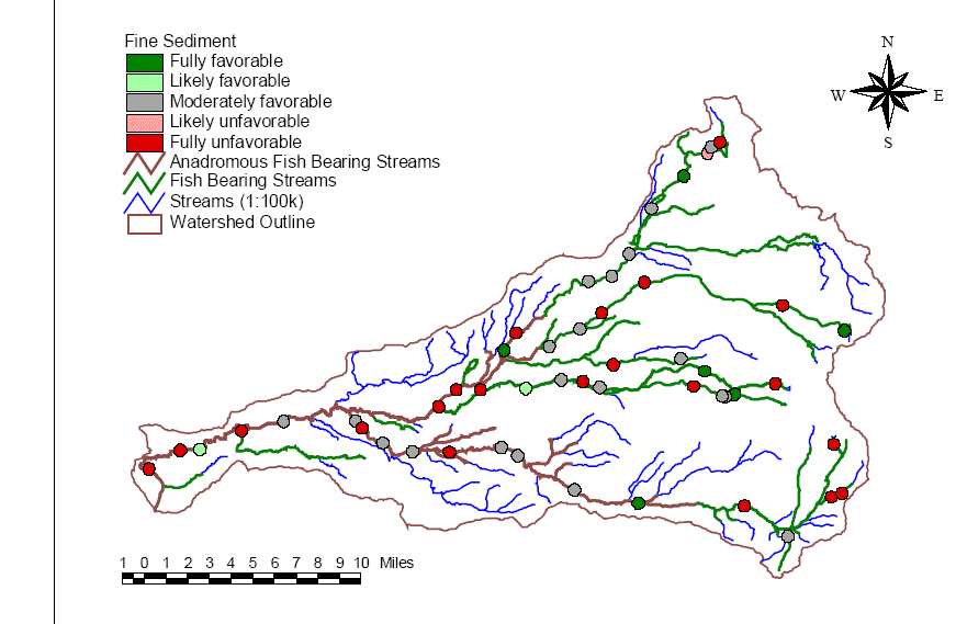 |
The Battle Creek WA EMDS truth value color coding for fine sediment, similar to that on the bar chart above, is shown here as a map. Several sites with "fully favorable" conditions are at the top of the watershed in the headwaters of Bailey Creek and Digger Creek. The site in the northeast corner below NF Battle Creek Reservoir may be buffered from upstream sediment sources because the reservoir acts as a sediment trap. The other favorable sites are on the South Fork below Panther Creek and on the North Fork Battle Creek near Bailey Creek. This map is from Figure 6 in the Battle Creek WA. |
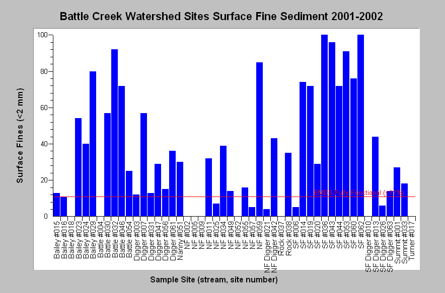 |
This chart shows surface fine sediment of less than 2 mm found in pool tail crests at all Battle Creek WA sites measured. Fines were very high (> 50%) at numerous South Fork Battle Creek locations, on the lower mainstem, at two Bailey Creek sites, on the North Fork above the NF Battle Creek Reservoir, and at one location on Digger Creek. The reference line is 11% surface fine sediment and fines less than this amount represent fully favorable EMDS conditions. Chart is from KRIS Battle Creek V 2.0 with data from Terraqua (2004). |
Median Particle Size Distribution: The Battle Creek WA captured data on median particle size, also known as D50, at 49 sites throughout the Battle Creek watershed. Their results were as follows:
Again the Battle Creek WA found no relationship to upland conditions using a power analysis: "In other words, variability in none of the sediment source factors was statistically related to observed particle size in the Battle Creek watershed."
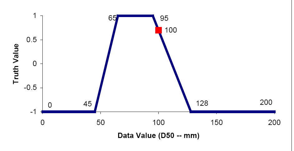 |
This EMDS rating curve for D50 from the Battle Creek WA shows Truth Values of 1 equal "fully favorable" and -1 equal "fully unfavorable". Fully favorable median particle size distribution for salmonids according to EMDS falls within the range of 60-96 mm, partially favorable conditions extend from 45 mm to 60 mm and from 96 mm to 128 mm. Values falling outside the 45-128 mm category are "fully unsuitable" for salmonids according to EMDS. This is Figure 3 from the Battle Creek WA. |
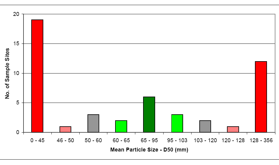 |
The median particle size distribution (D50) at all Battle Creek WA sites as a frequency histogram with color coding for suitability for salmonids from an EMDS rating curves is displayed at left. Fine sediment dominates sites with D50 values less than 45 mm, but larger unsuitable values (>128 mm) are poorly suited for salmonids because they are too large for spawning use. Color codes are red = fully unfavorable, pink = likely unfavorable, grey = moderately favorable, light green = likely favorable and dark green = fully favorable. There are 33 sites with fully or partially unfavorable conditions and 11 with somewhat or fully suitable median particle size. This chart is taken from Terraqua (2004) where it appears as Figure 7. |
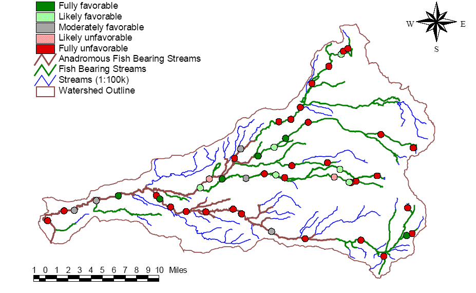 |
This
map from the Battle Creek WA EMDS shows EMDS D50 results with sites
showing fully or likely favorable conditions and sites showing unfavorable
or likely unfavorable conditions. Unfavorable sites are widespread in their
geographic distribution. This map is from Figure 8 in the the Battle
Creek WA.
|
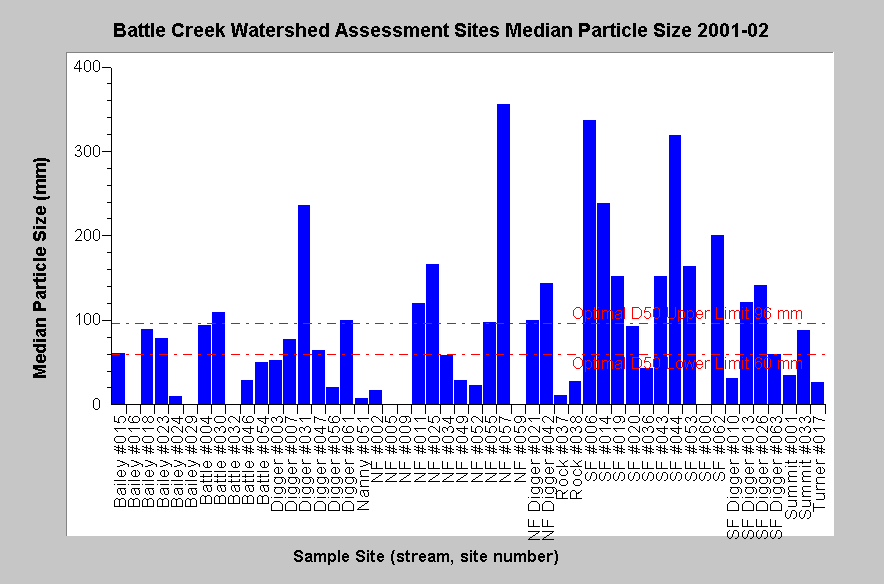 |
This chart shows the raw data results by site for median particle size distribution (D50) at all Battle Creek WA sites. Reference lines show the EMDS fully suitable range for salmonids of 60-96 mm. Four sites with very large D50 (>200 mm) are located on the mainstem South Fork Battle Creek and one site each in this D50 range also occur on Digger Creek and the North Fork Battle Creek. Sites values with small D50 largely overlap with those noted for high surface fines above. Chart is from KRIS Battle Creek V 2.0 with data from Terraqua (2004). |
|
Related
Pages
|
|
| Battle Creek Overview | KRIS General Background |
|
Stream Conditions: Sediment and Salmonid Habitat
|
|
![]()
References
Armentrout, S., H. Brown, S. Chappell, M. Everett-Brown, J. Fites, J. Forbes, M. McFarland, J. Riley, K. Roby, A. Villalovos, R. Walden, D. Watts, and M.R. Williams, 1998. Watershed Analysis for Mill, Deer, and Antelope Creeks. U.S. Department of Agriculture. Lassen National Forest. Almanor Ranger District. Chester, CA. 299 pp. [6.0 Mb]
Cordone, A.J. and D.W. Kelley. 1961. The influences of inorganic sediment on the aquatic life of streams. Reprint from California Fish and Game. Vol. 47, No. 2. California Department of Fish and Game, Inland Fisheries Branch. Sacramento, CA. 41 pp. [155k]**
Gallo, K. 2002. Field protocols: Aquatic and Riparian Effectiveness Monitoring Program for the Northwest Forest Plan: Version 1.0. U.S. Forest Service, Corvallis, OR. 54 pp. [125 Kb]
Gangmark, H.A., and R.G. Bakkala. 1960. A comparative study of unstable and stable (artificial channel) spawning streams for incubating king salmon at Mill Creek. Calif. Fish and Game, vol. 46, no. 2, pp. 151-164.
Terraqua, Inc. 2004. Battle Creek Watershed Assessment :Characterization of stream conditions and an investigation of sediment source factors in 2001 and 2002. Performed under contract to the Battle Creek Watershed Conservancy, Manton, CA. Funds from the Anadromous Fisheries Restoration Program and U.S. Fish and Wildlife Service under Agreement DCN: 11330-1-J113.
![]()
| www.krisweb.com |