 |
Battle Creek Overview | Bibliography | Home | |
The purpose of the Battle Creek Watershed Assessment (WA) (Terraqua, 2004) was to document existing aquatic conditions by collecting and interpreting baseline aquatic data from 50 locations and "to identify and prioritize for treatment sediment sources within Battle Creek". This charge did not include assessing changes in flow regimes that might be related to land use activities, although land use is recognized as influencing peak flows and flood frequency (Montgomery and Buffington, 1993; Jones and Grant, 1996).
The U.S. Forest Service's (Armentrout et al., 1998) Watershed Analysis for Deer, Mill and Antelope Creeks (Armentrout et al., 1998) described rain-on-snow risk in those adjacent watersheds as follows:
"In addition to lying within areas subject to snowpack melt from rainfall events, several other factors influence the risk of increased peak flows. These include the amount of road density, the location of these roads relative to drainage ways and the extent to which road ditches flow to channels. Other factors include the amount of timber harvest that has occurred, particularly the degree to which young stands have replaced old growth, the drainage density of the watersheds, and the amount of precipitation an area receives."
Findings of Battle Creek Watershed Assessment
Terraqua (2004) described the risk of rain-on-snow as follows:
"Areas within the transient snow zone, the portion of the watershed where snow accumulates and melts on a seasonal basis, are sometimes referred to by hydrologists as the 'rain-on-snow' zone. Rain storms that occur within this area at certain times of year may precipitate rain onto an existing snow pack in storms known as 'rain-on-snow' events. Rain-on-snow events have the potential to influence the amount and timing of runoff and sediment delivery because of the combination of precipitation and melting of the snow pack. Runoff and sediment delivery potential can increase in the presence of factors that increase the rate of snow melt, particularly in unvegetated areas within the rain-on-snow zone which may be relatively warmer, are subject to higher winds, and exposed to higher levels of solar radiation (Harr 1986; Berris and Harr 1987; and Heeswijk et al. 1995).
Armentrout et al. (1998) considered the elevation band from 3,600 to 5,000 feet above sea level to be the 'dominant rain-on-snow zone' in nearby Deer, Mill and Antelope creeks. They characterized a watersheds sensitivity to the rain-on-snow phenomenon by calculating the percent of a watershed within this zone. For our analysis of rain-on-snow the proportion of each site-specific watershed within the rain-on-snow zone was calculated as the area of overlap between the individual site-specific watershed and the elevation band between 3,500 and 5,000 feet."
|
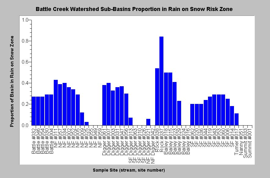
This chart shows, for each Battle Creek WA sub-basin, the percentage or proportion that is in the rain-on-snow zone. According to the WA: "Approximately 27 percent of the Battle Creek watershed is within the dominant rain-on-snow zone from 3,500 to 5,000 feet above sea level. On average, 23 percent of the area within 51 site-specific watersheds lies within the dominant rain-on-snow zone." The chart shows that the two creeks with highest proportion of watershed area in this zone are Bailey Creek (50%) and Rock Creek (80%). From KRIS Battle Creek V 2.0. |
The Battle Creek WA concluded that the "rain-on-snow area does not appear related to more direct evidence of sediment delivery including fine sediment levels or median particle size." They drew no conclusions about changes in flow regimes that may have resulted from land uses in the rain-on-snow zone. They did note that rain-on-snow may occur at higher elevations than recognized by Armentrout et al. (1998), which may have confounded study relationships to instream measurements: "Channel instability resulting from the January 1997 rain-on-snow event suggests that significant sediment inputs from such storms occurs at higher elevations, perhaps from 4,000 feet to the top of the watershed. This may partially explain the lack of statistically significant relationships between rain-on-snow and fine sediment and particle size, and the unanticipated relationship between rain-on-snow and residual pool depth, in our analysis."
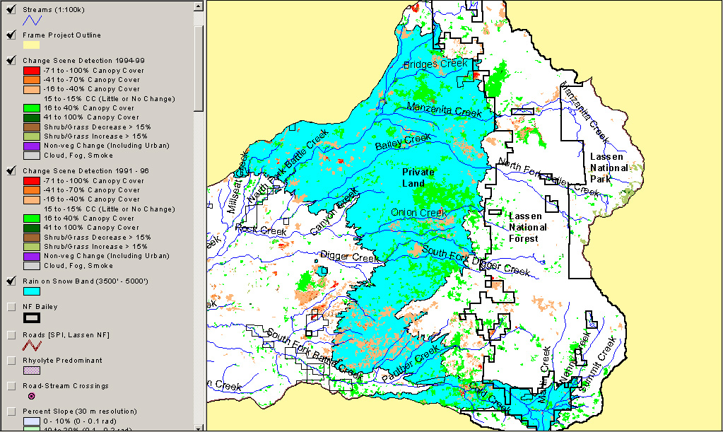 |
This map shows the rain-on-snow zone (3500-5000 feet) recognized by Terraqua (2004). Also displayed is the change scene detection Landsat data published by the U.S. Forest Service Spatial Analysis Lab (Levien at al., 2002). This includes data from 1991-1996 and 1994-1999 showing both decreases (orange/red) and increases (shades of green) in forest canopy. Map is from KRIS Battle Creek V 2.0. |
|
Related
Pages
|
|
| Battle Creek Overview | KRIS General Background |
|
Pool Frequency and Depth in Battle Creek |
|
![]()
References
Armentrout, S., H. Brown, S. Chappell, M. Everett-Brown, J. Fites, J. Forbes, M. McFarland, J. Riley, K. Roby, A. Villalovos, R. Walden, D. Watts, and M.R. Williams, 1998. Watershed Analysis for Mill, Deer, and Antelope Creeks. U.S. Department of Agriculture. Lassen National Forest. Almanor Ranger District. Chester, CA. 299 pp. [6.0 Mb]
Berris, S. N. and Harr, R. D., 1987. Comparative snow accumulation and melt during rainfall in forested and clear-cut plots in the western Cascades of Oregon: Water Resources Research. Y. 23, p. 135- 142.
Harr. R. D., 1986. Effects of clearcutting on rain-on-snow runoff in western Oregon: a new look at old studies: Water Resources Research, 22(7): 1095-1100.
Heeswijk, M., J. S. Kimball, and D. Marks. 1995. Simulation of water available for runoff in clearcut forest openings during rain-on-snow events in the western Cascade Range of Oregon and Washington. US Geological Survey Water-Resources Investigations Report 95-4219.
Jones, J.A. and G.E. Grant. 1996. Peak flow response to clear-cutting and roads in small and large basins, Western Cascades, Oregon. Water Resources Research, April 1996. Vol. 32, No. 4, Pages 959-974.
Levien, L., C. Fischer, P. Roffers, B. Maurizi, and J. Suero. 2002. Monitoring Land Cover Changes in California Northeastern California Project Area. Cooperative venture of USDA Forest Service Spatial Analysis Lab and California Department of Forestry Fire and Resource Assessment Program, Sacramento.
Montgomery, D. R. and J.M. Buffington, 1993. Channel classification, prediction of channel response, and assessment of channel condition. TFW-SH10-93-002. Prepared for the SHAMW committee of the Washington State Timber/Fish/Wildlife Agreement. Seattle, WA. 110 pp. [1.75Mb]
Terraqua, Inc. 2004. Battle Creek Watershed Assessment :Characterization of stream conditions and an investigation of sediment source factors in 2001 and 2002. Performed under contract to the Battle Creek Watershed Conservancy, Manton, CA. Funds from the Anadromous Fisheries Restoration Program and U.S. Fish and Wildlife Service under Agreement DCN: 11330-1-J113.
![]()
| www.krisweb.com |