 |
Battle Creek Overview | Bibliography | Home | |
![]()
|
Battle Creek Overview | Bibliography | Home | |
![]()
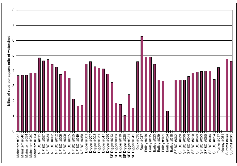
In the Battle Creek Watershed Assessment (WA), Terraqua (2004) evaluated roads as a potential sediment source and used road density, road stream crossings and roads near streams to check for associations with the quality of stream habitats as measured at sites throughout the watershed (see Terraqua methods). Kier Associates worked cooperatively with Terraqua, assimilating GIS data, providing road-related data summaries and capturing Battle Creek WA results in KRIS Battle Creek Version 2.0. A summary of findings regarding roads from the Battle Creek WA is presented below.
The University of California Sierra Nevada Ecosystem Project (U.C. Davis, 1996) made the following findings regarding roads and impacts to regional aquatic systems:
The U.S. Forest Service (Napper, 2001) noted that roads were a major source of erosion in the upper South Fork Battle Creek watershed, particularly those near streams or on steep slopes or unstable soil types. In the Watershed Analysis for Mill, Deer, and Antelope Creeks, which are adjacent watersheds to the south of Battle Creek, the USFS (Armentrout et al., 1998) noted "roads are the dominant source of surface erosion in the watersheds; more specifically, road crossings have been shown to be the primary erosion source." The USFS tries to limit road densities to 2.5 miles of road per square mile of watershed as a management objective on National Forest lands in basins harboring anadromous fish.
Findings of Battle Creek Watershed Assessment
The Battle Creek Watershed Assessment made the following findings regarding roads:
 |
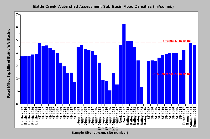
Near-stream roads in Battle Creek WA sub-basins (at left) were characterized by Terraqua (2004): "The near-stream road density in the Battle Creek watershed is approximately 3.4 mi./sq. mi. The average near-stream road density at 51 sites was 4.3 (± 1.6 SEM; range 0 to 7.9) mi./sq. mi. (at left). Sites with the highest near-stream road densities were generally located in the middle portion of the Battle Creek watershed. More specifically, sites with high near stream road densities were located in Rock Creek, Summit Creek, mainstem Digger Creek, and the upper reaches of North Fork Battle Creek." This chart is taken from the Battle Creek WA where it appears as Figure 20. Lack of detail and accuracy in the USGS 1:100000 hydrography layer may cause some loss of precision in calculation of this statistic (see note). |
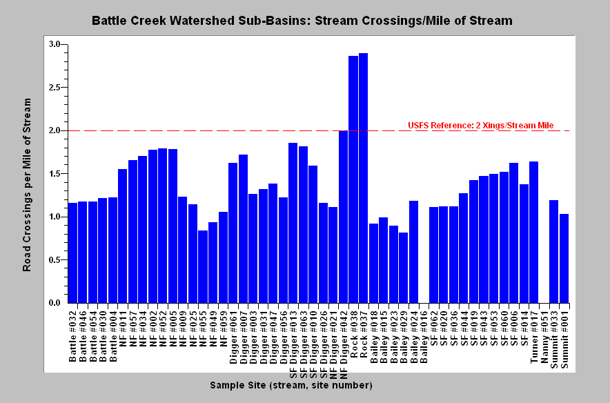 |
The number of road-stream crossings per mile in reaches above Battle Creek WA sites is shown here in a chart from KRIS Battle Creek v 2.0. Terraqua (2004) noted that: "The road-stream crossing frequency within the whole Battle Creek watershed is approximately 1.1 road-stream crossings per mile of stream. The average frequency of road-stream crossings at 51 sample sites was 1.3 (± 0.5 SEM; range 0 to 2.9) road crossing per mile of stream (Figure 21). The highest frequency of road-stream crossings generally occurred at the same sites which had high near-stream road densities." Reference line based on Armentrout et al. (1998), which is the target for Lassen National Forest in watersheds harboring anadromous fish. |
Terraqua (2004) found no statistically significant relationships between road parameters and fine sediment or other in-channel aquatic habitat data collected as part of the Battle Creek WA:
"Perhaps it should not be surprising that road-related sediment sources do not appear to have a direct relationship on stream conditions in Battle Creek at the watershed scale. The density of roads in the Battle Creek watershed is generally lower than those levels shown to have measurable impacts to streams in other studies. Cederholm et al. (1980) found that sediment levels remain near natural levels where less than 2.5 percent of a basin's area is roaded (a road equivalent to about 4.8 mi./sq. mi.). Only 4 of 51 site-specific watersheds in our analysis had road densities greater than 4.8 mi./sq. mi.."
|
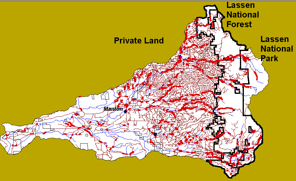
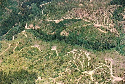
This map from KRIS Battle Creek v 2.0 shows Battle Creek roads with segments within 100 meters of streams highlighted. Some reaches on Manzanita Creek and the South Fork and its tributaries around Mineral may be paralleled by State highways. Road data are from Sierra Pacific Industries, the USFS, and USGS but highlights of near stream road segments created by Dr. Paul Trichilo of Kier Associates and the KRIS project. Lack of detail and accuracy in the USGS 1:100000 hydrography layer may cause some loss of precision in calculation of near stream roads (see note) |
|
Related
Pages
|
|
| Battle Creek Overview | KRIS General Background |
| Battle Creek Rain on Snow Potential | |
![]()
References
Armentrout, S., H. Brown, S. Chappell, M. Everett-Brown, J. Fites, J. Forbes, M. McFarland, J. Riley, K. Roby, A. Villalovos, R. Walden, D. Watts, and M.R. Williams, 1998. Watershed Analysis for Mill, Deer, and Antelope Creeks. U.S. Department of Agriculture. Lassen National Forest. Almanor Ranger District. Chester, CA. 299 pp. [6.0 Mb]
Kondolf, G. M., R. Kattelmann, M. Embury, and D.C. Erman, 1996. Status of riparian habitat. Chapter 36 of Sierra Nevada Ecosystem Project: Final report to Congress. Vol. II, Assessments and scientific basis for management options. University of California, Centers for Water and Wildland Resources. Davis, CA. 22 pp. [1.4Mb]
Moyle, P.B. and P.J. Randall. 1998. Biotic Integrity of Watersheds in the Sierra Nevada, California. Conservation Biology [Conserv. Biol.]. Vol. 12, no. 6, pp. 1318-1326. Dec 1998.
Napper, C. O., 2001. Cumulative Watershed Effects - Battle Creek. Analysis of beneficial uses and water quality criteria to evaluate CWE susceptibility. U.S. Department of Agriculture, Forest Service, Lassen National Forest . Susanville, CA. 22 pp. [92 kb]
Terraqua, Inc. 2004. Battle Creek Watershed Assessment :Characterization of stream conditions and an investigation of sediment source factors in 2001 and 2002. Performed under contract to the Battle Creek Watershed Conservancy, Manton, CA. Funds from the Anadromous Fisheries Restoration Program and U.S. Fish and Wildlife Service under Agreement DCN: 11330-1-J113.
University of California at Davis. Sierra Nevada Ecosystem Project: Final report to Congress. Vol. II, Assessments and scientific basis for management options. Davis: University of California, Centers for Water and Wildland Resources, 1996.
![]()
| www.krisweb.com |