
| Area | Basin-wide |
| Topic | Geology: Percent Rhyolite in Battle WA Sub-Basins |
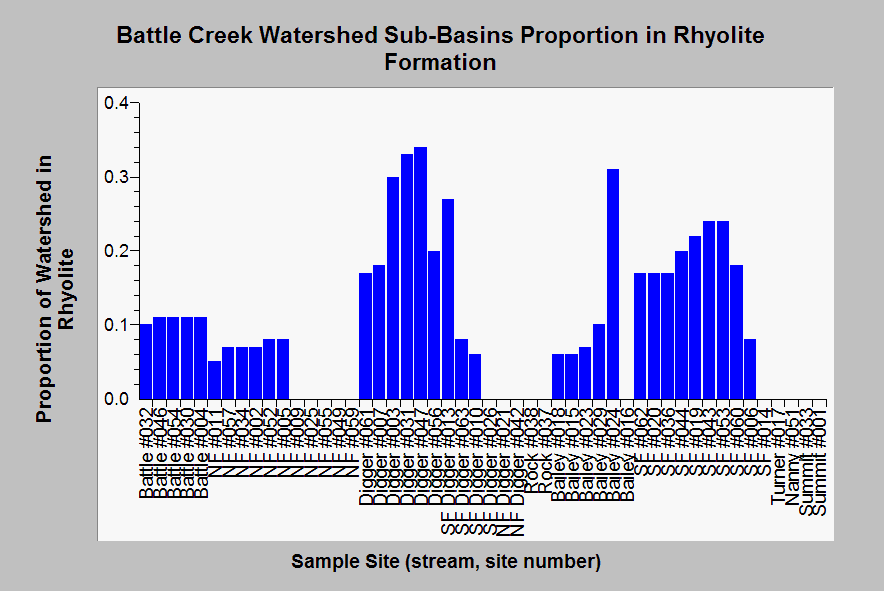
| Caption: This chart shows the percentage or proportion (1.0 = 100%) of various Battle Creek WA sub-basins that are comprised of rhyolitic geology or soil types. According to the USFS, rhyolite areas are highly erodible and cause high contributions of sediment when disturbed. Terraqua (2004) found that "approximately 11 percent of the Battle Creek watershed is dominated by rhyolitic soils. Rhyolitic soils are generally located in upper Manzanita and North Fork Bailey Creeks and in the vicinity of Blue Ridge which is drained by Soap, Panther, and South Fork Digger Creeks. These soils occurred within 36 of 51 site-specific watersheds." Sites on the South Fork below Panther Creek (#006) and lower Digger Creek would be more subject to sediment increases from rhyolite areas, if patterns of land use disturbance are increasing erosion. Data from the USGS and Chico State University but data summary for sub-basins run by Dr. Paul Trichilo of Kier Associates and the KRIS project. See Info Links for more information. | |
 |
To learn more about this topic click Info Links .
To view additional information (data source, aquisition date etc.) about this page, click Metadata .
To view the table with the chart's data, click Chart Table web page.
To download the table with the chart's data, click upland_source_fin_12_10_03.dbf (size 17,098 bytes)
To download the table with the chart's data as an Excel spreadsheet, click upland_source_fin_12_10_03.dbf.xls (size 28,611 bytes) .
| www.krisweb.com |