
| Area | Basin-wide |
| Topic | Vegetation: Landsat Veg/Tree Size Summary of Nine Battle WA Sub-Basins |
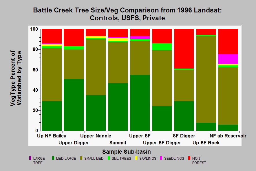
| Caption: This chart shows the summaries from Landsat imagery of tree size and vegetation type for selected Battle Creek Watershed Assessment study sub-basins. The three basins at left are lightly managed, but at high elevation, the middle three are USFS watersheds managed for timber, and the three to the right are mostly private industrial timber lands. Note the latter have fewer Large Trees (>30 inches) and more Non-Forest, which indicates more active timber harvest. Small-Medium trees in industrial timber watersheds also indicate early seral conditions due to recent past timber harvests. Areas above the North Fork Battle Creek Reservoir also cross in to Mountain Chaparral terrain; therefore, some early seral signatures may be owing to natural stunting at high elevation, although upper Nannie may closer to the range of natural variability at this elevation. Data from USFS and CDF. See Info Links for more information. Vegetation types and tree size classes by diameter at breast height (DBH) are as follows: Large = >30" DBH, Medium/Large = 20-29.9" DBH, Small/Medium = 12-19.9" DBH, Small = 5-11.9" DBH, Saplings = 1-4.9" DBH, Non-Forest = No trees, shrubs, grass, bare soil. | |
 |
To learn more about this topic click Info Links .
To view additional information (data source, aquisition date etc.) about this page, click Metadata .
To view the table with the chart's data, click Chart Table web page.
To download the table with the chart's data, click select_tree_size_usfs_private.dbf (size 1,135 bytes)
To download the table with the chart's data as an Excel spreadsheet, click select_tree_size_usfs_private.dbf.xls (size 5,120 bytes) .
| www.krisweb.com |