 |
 |
Background | Hypotheses | Bibliography | Maps | Home |
|
|
Background | Hypotheses | Bibliography | Maps | Home |
Recent Timber Harvest on the Gualala
Historic Timber Harvest in the Gualala Basin
![]()
Note: Geologic information, electronic maps and models within the KRIS Gualala project are meant to provide background information only and not as a site-specific decision making tool. California requires that licensed geologists be involved directly in decisions related to geologic conditions (see requirement). The California Geologic Survey has reservations regarding the content of KRIS Gualala (see comment note), including slope stability maps, and their endorsement of the contents of this page is not implied.
![]()
The Gualala River basin has high, natural geologic instability and 150 years of intensive land use. The natural instability of the landscape, particularly in the eastern portion of the Gualala Basin underlain by Central Belt Franciscan Mélange Terrain, has produced naturally high sediment levels during different epochs (see CSG Appendix on Geology). Sediment yield since World War II has been so high that it has played a part in the loss of several fish species (see Gualala Fish Populations page). Continuing timber harvest and road construction on unstable ground has in part prevented aquatic recovery from 1955 and 1964 storm damage (see Hypothesis #3). Other land uses such as ranching and vineyards have the potential to contribute to cumulative effects either through related sediment yield or flow depletion.
By far the largest land use impact in the Gualala has been timber harvest; consequently, much of the page below is on that topic. There have been several waves of logging in the Gualala and the earlier ones were extremely destructive to the watershed and are known to have caused huge sediment contributions (see Gualala Watershed Synthesis Report).
Early Impacts (1850-1945)
The earliest logging began in the Gualala in the 1850's, but the reach of logging with oxen was restricted to less remote watersheds and the damage slow, because it took several men all day to chop down one tree (see Gualala Logging History).
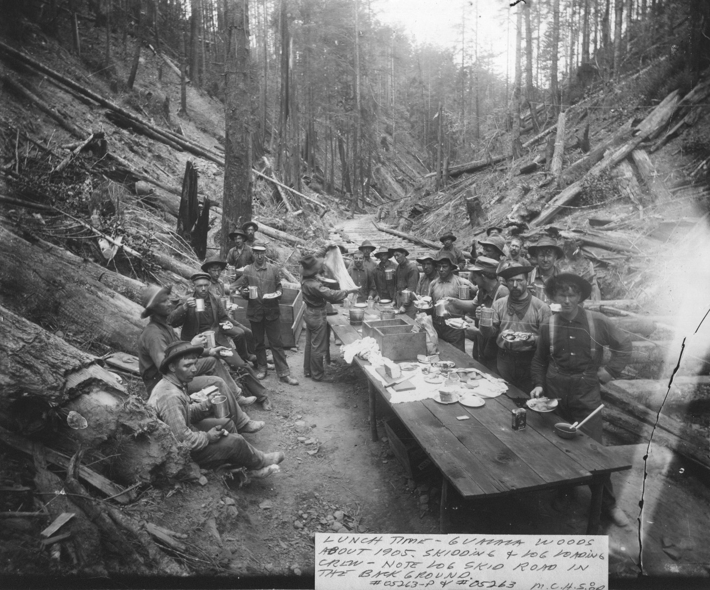 |
The earliest logging took place near the coast, so some North Fork Gualala tributaries were hit hard. The picture at left shows logging from about 1905, likely in Doty Creek. Tributary channels were paved with log butts, which is an impairment that persisted in some places until recent time. The earliest loggers however, had no use for sub-merchantable trees and may not have clear cut as a result. The destructive impact and reach of logging extended with the advent of railroads and steam donkeys, well up into the South Fork Gualala. Still the extent of damage paled by comparison with Post WW II logging. |
With the advent of the steam donkey and construction of railroads, logging from 1880-1920 covered much more area. Some parts of the upper South Fork were burned repeatedly to attempt forest to pasture conversion. The high rainfall during this period would have been linked with high river lows, which would help to flush sediment. A reduction in average rainfall at the nearby Fort Ross rain gauge is apparent for earlier and more recent periods of record (see climate note). From about 1920 to 1945, the Gualala River watershed was in recovery from past logging, with little active timber harvest. Railroad logging and steam donkeys used extensive cable systems that could drag logs from 3/4 of a mile away. This early cable logging likely allowed quicker watershed recovery than from Post WW II logging, similar to Freshwater Creek in Humboldt County (Higgins, 2001). Before the wave of sediment from the 1964 flood hit the Gualala River, it was a world famous steelhead fishing river with a substantial sport harvest of coho salmon.
Post World War II Land Use Impacts (1945-1975)
The impacts of logging between 1945 and 1975 are still being felt in the Gualala River watershed today (CA Resources Agency, in press). Inner gorge failures during the flood caused narrow, tree lined streams to become open canyons of bare soil. Because the eastern basin is earthflow terrain, once streamside slides are initiated, they tend to reactivate with every subsequent low recurrence interval storm event, like a giant sediment conveyor belt into the river. Old roads built along streams caused landslides or compacted soils so that riparian trees have not re-grown (see below). Old landings and road beds still fail during major storm events fail. Debris slides on slopes where Douglas fir trees were harvested in the eastern Gualala can be expected to yield sediment in pulses from 8-30 years later, as tree roots rot out (Sidle, 1986). Large earthflows and rotational-translational slides activated by inner gorge logging or the inordinate height of flood water in 1955, 1964 and 1974 may still be actively contributing sediment today.
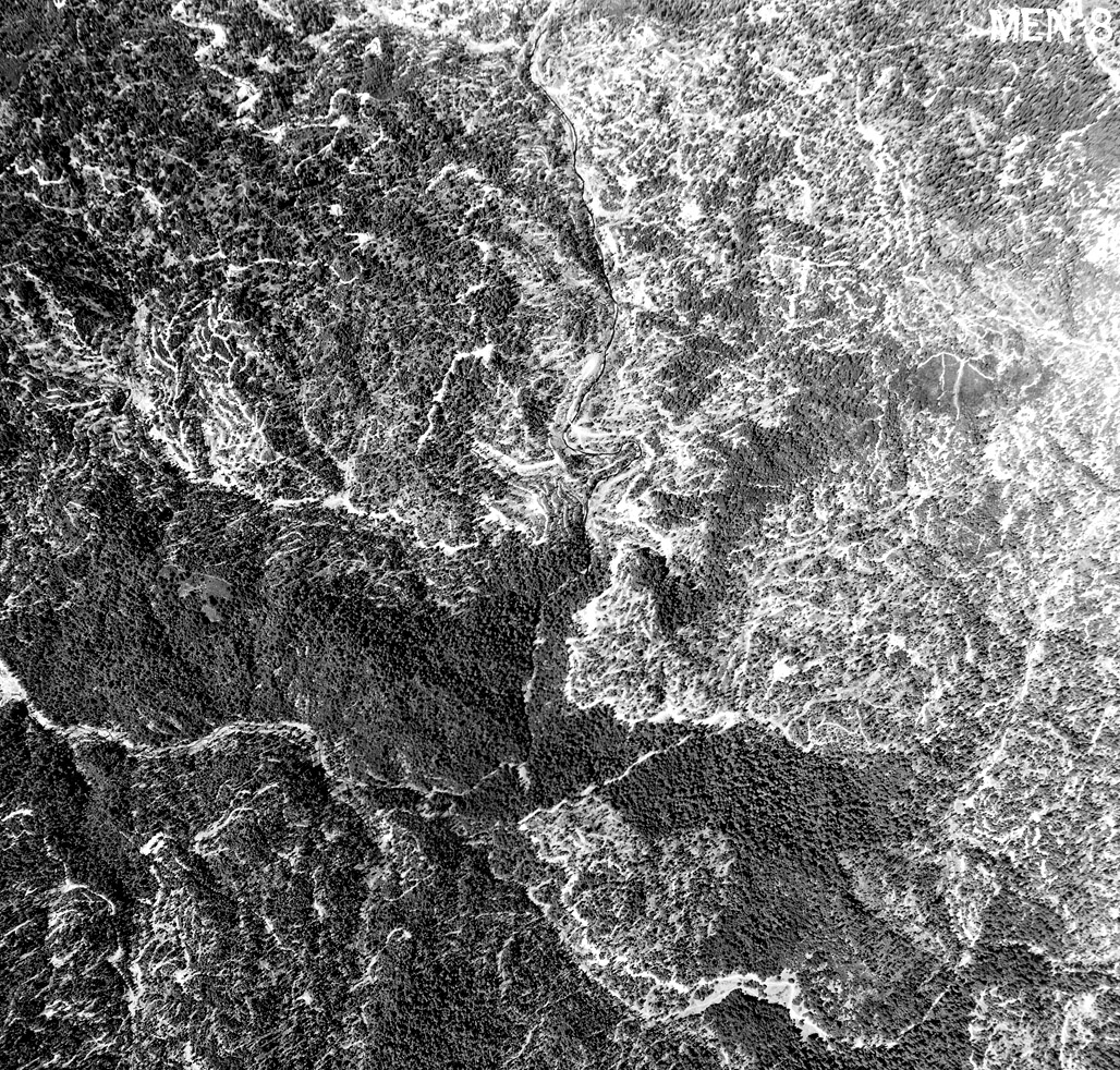 |
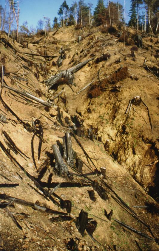
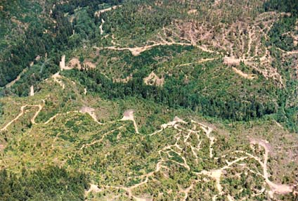
This
photo shows an unknown location in the North Fork Gualala watershed in 1963
during intensive post WW II logging. Note extensive road skid trail network,
with haul roads often following stream courses. This widespread mechanized
logging, just prior to the 1964 flood, set the stage for probably the largest
human induced pulse of sediment to the Gualala. Photo courtesy of Don Morse,
California Department of Forestry (FRAP), North Coast Watershed Assessment
Program.
|
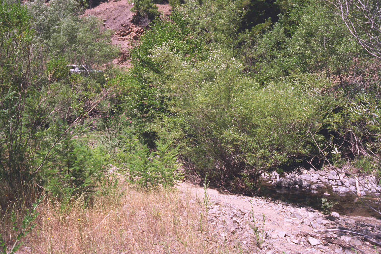 |
The photo at left shows South Fork Fuller Creek 30-40 years after logging damage with a riparian zone dominated by willow, which leaves the stream subject to warming. The young conifers in the riparian zone at left will provide a cooler microclimate when they mature in 50-75 years. Their ability to provide lasting large wood materials for channel complexity will improve until trees are over 100 years old. The truck visible through the willows is parked on a road that was constructed next to the stream in the 1950's and has remained in active use for logging. Streamside roads such as these make full recovery of a stream impossible. Note that the streambed is comprised of large, angular cobble, with some fine sediment. This larger median particle size distribution is owing to high hydraulic energy at this site (Rosgen B2), but also because continuing sediment yield from debris slides has ceased. Photo provided courtesy of Pat Higgins. 1996. |
The California Department of Forestry in the Gualala River Watershed Assessment (in press) noted that: After initial land clearing and forest removal, prolonged grazing spanning decades in the northeast and east of the watershed prevented timely reestablishment of canopy cover over watercourses. With the decline of ranching in recent years, young sapling sized conifers/hardwoods have re-established in riparian areas. Some grazing impacts remain in the basin today (see below).
Modern Sediment Related Cumulative Watershed Effects (1975-2001)
Timber Harvest/Western Basin
While the sediment yield from the Post WW II era is still cycling through the Gualala River and its tributaries, there is substantial evidence to indicate that sediment yield from recent land use remains high (see Hypothesis #3). When this most recent wave of land use began, the landscape of much of the Gualala watershed had already been profoundly disturbed, in some places twice. Sediment discharge from recent activity may be much lower than those from 1945-75 but still significant, similar to Bear Creek (Humboldt County), where Pacific Watershed Associates (1998) found that sediment yield from Post WW II logging yielded about six times more sediment than the 1997 storm. In the South Fork Ten Mile River basin, Matthews (2000) found that landslides were far fewer than in previous waves of logging but that sediment yield was high and associated with roads.
The California Department of Water Resources noted in the Gualala River Watershed Assessment (in press) that major, recent high flow events in the Gualala basin besides 1955 and 1964, were 1974, 1986, 1993, 1995 and 1997. Two major storm events occurred early in 1995 in both January and March. High flows are associated with high rainfall, which can saturate slopes and trigger landslides and also exacerbate surface and gully erosion. Extensive timber harvest has taken place in many Gualala sub-basins from 1985 to 2001 (see Gualala Timber Harvest Background page), including just prior to 1995 and 1997, and dense road networks have been constructed. According to the Technical Support Document for the Gualala River TMDL roads are the major source of sediment (CRWQCB, 2001). Metrics available for assessment of Gualala stream channels are consistent with a pattern of high sediment yield in the 1995 to 2000 period.
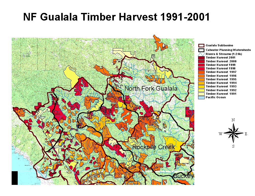 |
Timber harvests as mapped by the California Department of Forestry by year from 1991-2001 is displayed at left. The timber harvests mapped under-represent cumulative watershed effects because timber harvests between 1985 and 1990 are not included. Timber harvest may actually occur over several years after a THP is approved and many harvests from that era still may be contributing sediment. |
Reeves et al. (1993) found that basins on the Oregon Coast retained diverse assemblages of salmonid species when timber harvest was below 25% of a watershed's area. The fish community tended to be non-diverse, with one species of salmonid dominating, when logging had taken place in more than 25% of a watershed. Fish communities in these subbasins tend to be dominated by steelhead and coho are either present at remnant levels or not present at all. Timber harvest in some Gualala River Calwater planning areas has exceeded this threshold by two or three fold. Reeves et al. (1993) noted that over-cutting was associated with habitat simplification, which in turn impacted salmonid diversity (see Habitat Typing).
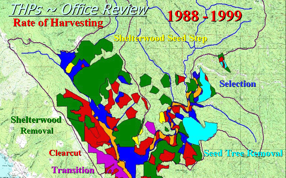 |
Timber
harvests in the Little North Fork Gualala River watershed from 1988 to 1999
as mapped by NMFS are depicted at left. Including additional timber harvests
in upper Little North Fork (see below) and Doty
Creek since 1999, 80% of the entire basin has been logged in just
13 years. Spatial data provided by the National Marine Fisheries Service
(NMFS), Santa Rosa.
|
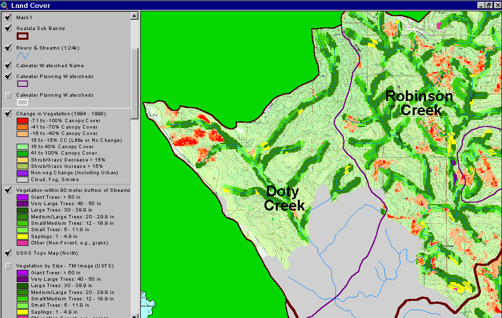 |
New
timber harvest show at left as red and orange indicating 40-100% canopy
removal between 1994 and 1998. The "change scene detection" is provided
by CDF FRAP and is based on two Landsat sequences. The gray is the fog bank
that obscured the 1998 image. A 90 meter buffer riparian zone based on Landsat
is also displayed following USFS classification. The upper Little North
Fork logging extends into riparian areas, which will reduce large wood recruitment
to areas downstream in the event of a landslide or debris torrent. The latter
is a common mechanism for large wood delivery to streams and the large wood
entrained in the slides catches up in jams metering sediment delivery and
buffer some downstream reaches from impacts.
|
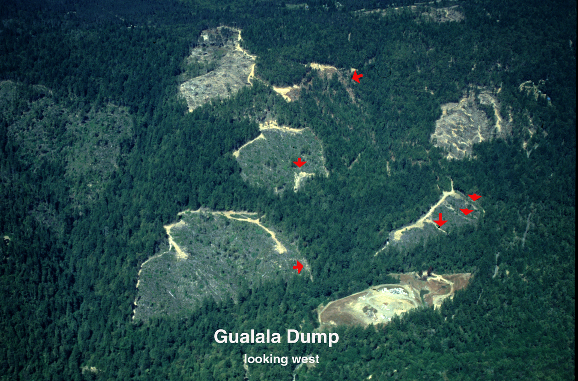 |
The
upper Little North Fork Gualala River is depicted at left with clear cuts
in inner gorge locations. These slopes are unstable and landslides are highlighted
with arrows. Land management and the landscape have been tested by numerous
large storm events in recent (January 1995, March 1995, January 1997) and
very high rainfall years (1998). Some of these landslides are contributing
sediment to the stream. Image provided by the Russian River Residents Against
Unsafe Logging.
|
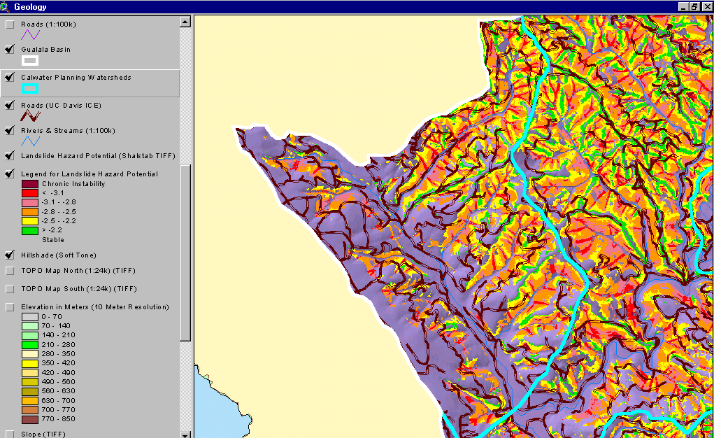 |
The
image at left from the KRIS Gualala Map project shows the risk of shallow
debris slides in the Little North Fork Gualala River basin. Highest risk
slopes show in red and orange colors. The Little NF follows the San Andreas
Fault, which triggers landslides periodically with seismic shaking. High
debris slide risk occurs in inner gorge areas along Doty Creek, in headwater
areas and along draws, which are largely Class III stream courses. The road
network associated with logging crosses unstable slopes. This poses an elevated
risk of debris sliding, which likely lead to sediment contributions from
some locations in high intensity storms since 1995. See KRIS Web background
page on Modeling Shallow Landslides
for more background information and limits of use of SHALSTAB for management
decisions.
|
 |
A Gualala River ephemeral (Class III) stream after a timber harvest and site preparation activities is shown at left. While timber harvest in Class III streams does not directly effect water temperatures, because of lack of surface flow in summer, removal of vegetation does cause sediment contributions to streams. The site preparation seems to have burned hot up this draw in lower Buckeye Creek. Photo provided by the Russian River Residents Against Unsafe Logging. |
Bedload movement on minor storm events in a southwestern Oregon stream suffering similar cumulative effects related to logging had scour and fill on low recurrence interval storms sufficient to scour out or bury salmon redds (Nawa et al., 1990). Similar mechanisms are likely operating in many Gualala River streams and are likely one of the major factors limiting the success of coho salmon in the North Fork drainage (see Hypothesis #2).
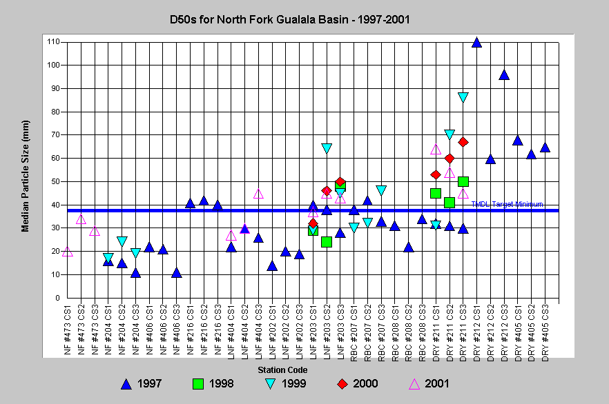 |
The
chart at left shows the median particle size distribution of the streambed
at several locations in the North Fork Gualala River basin between 1997
and 2001. Most values in the mainstem North Fork (NF), Little North Fork
(LNF), and Robinson Creek (RBC) are less than two inches in diameter and
are likely mobile on minor storm events. Several stations show considerable
changes in median particle size distribution, suggesting active bedload
movement at those locations since 1997 (i.e. LNF #203 and DRY #211). The
latter is indicative of active sediment supply (see Hypothesis
#3).
|
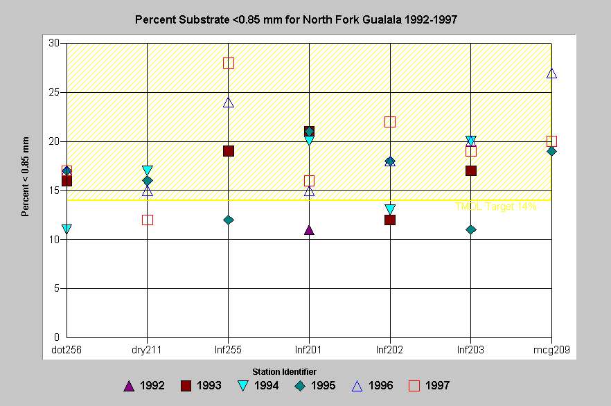 |
The
chart at left shows that most North Fork Gualala sampling locations had
high fine sediment (< 0.85 mm) levels likely to reduce egg and alevin
survival (see Stream Conditions:
Sediment and Salmonids Background page). Trends show higher values in
the Little North Fork at sites (lnf202 and lnf255) after the January 1997
storm, which would be consistent with sediment delivery by that event. Robinson
Creek shows a smaller increase from 1995 to 1997. The increase in fines
on McGann Creek suggests that a wave of sediment passed that monitoring
location in 1996.
|
Similar trends in fine sediment are evident for other intensively logged watersheds in northwestern California (Higgins, 2001). Fluctuations in fine sediment of this size class in the chart above shows that this fraction is highly mobile. If sediment sources were not continuing, the trend in this metric would be down. South Fork Ten Mile River subbasins showed similar increases in response to 76% logging between 1990 and 1999 and coho salmon were greatly reduced as a result (KRIS Ten Mile, at www.krisweb.com). The sediment not only limits salmonid spawning success but also fills in pools, which also limits rearing habitat.
|
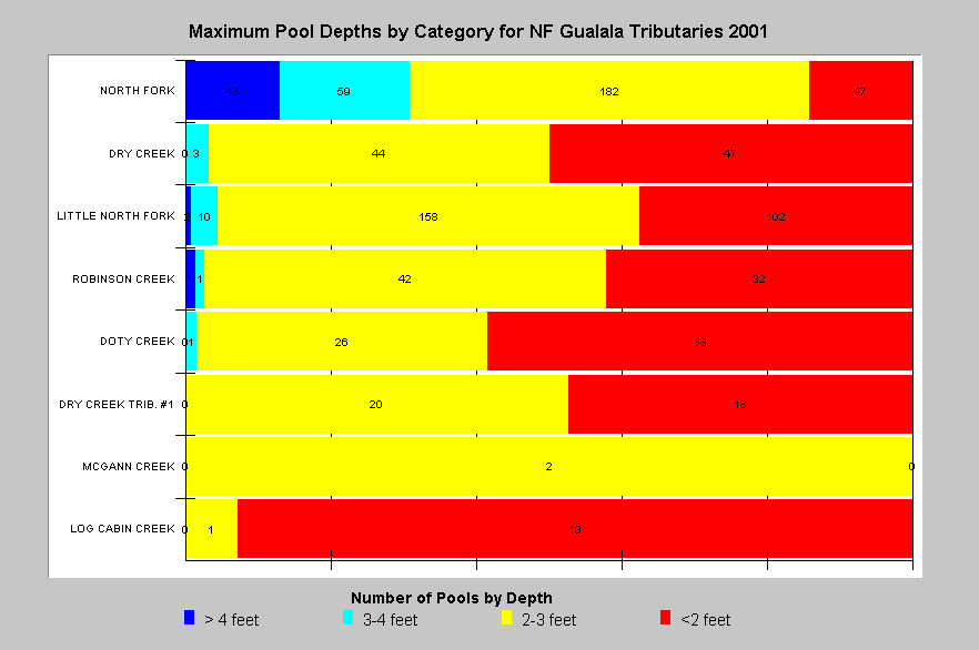
Maximum pool depths in North Fork sub-basin streams are similar in range to all streams surveyed in the Gualala River basin, with almost no pools over three feet deep except in the mainstem of the North Fork Gualala River, which is a 5th order stream. The lack of pool depth indicates major impairment with regard to salmonid production and suggests active aggradation and that salmonid carrying capacity (see Hypotheses #1 and #2). For example, only 12 of 272 pools measured on the Little North Fork were over three feet deep. Data provided by the California Department of Fish and Game. |
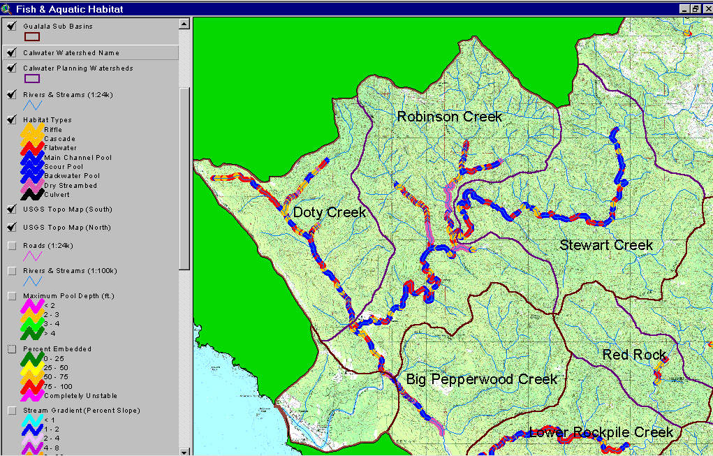 |
The image at left shows California Department of Fish and Game habitat typing results displayed as habitat frequency by length for the North Fork Gualala Basin. The predominance of pools in the mainstem North Fork and lower Little North Fork would suggest suitable habitat for salmonids. Lacks of pools in Doty Creek (upper right tributary in Doty Creek Calwater) and in the upper Little North Fork suggest aggradation. Similarly, the extensive dry reaches in Robinson, McGann, Dry Creeks and lower mainstem South Fork are also a clear indication of major, recent aggradation and that salmonid rearing habitat is severely impaired. |
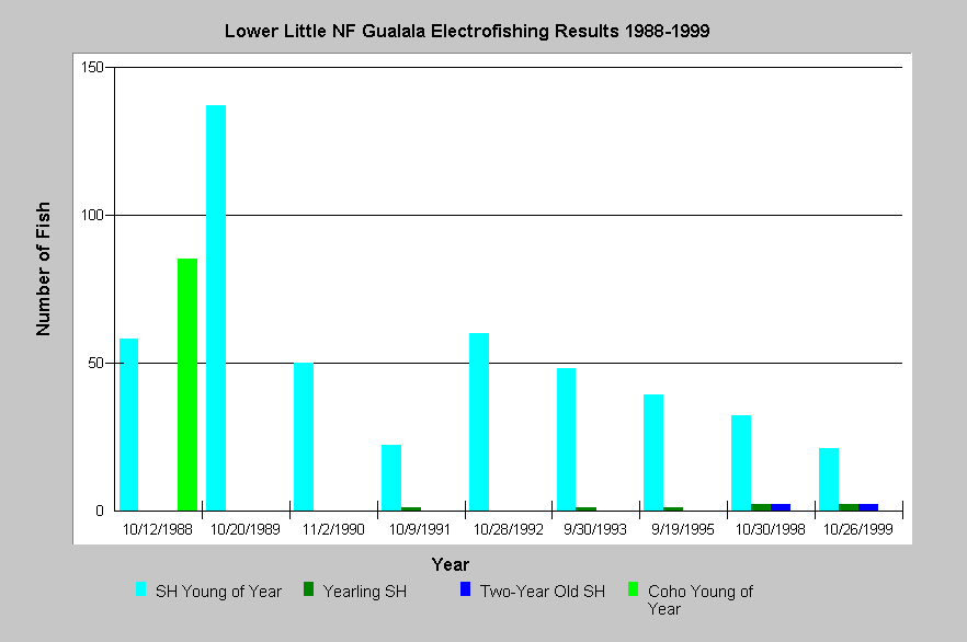 |
Long-term electrofishing data sets collected by CDFG in the lower Little North Fork show samples dominated by steelhead young of the year but with yearling and two year old fish present. Coho were present only in 1988, when hatchery coho were being planted. Steelhead have decreased in the lower Little North Fork index reach, particularly since 1992 in number and density, but biomass has not shown a similar trend. This is consistent with diminishing habitat as the Little North Fork aggraded and pools filled in (see Hypothesis #3). Data provided courtesy of the California Department of Fish and Game. |
Eastern Gualala Basin Cumulative Watershed Effects
Several subbasins of the Wheatfield Fork have low pool frequency by length, shallow pool depth, warm water temperatures and high fine sediment. While land use has not been as active or intensive as in the western basin, the landscape itself is more sensitive to management. Where post WW II logging took place in Douglas fir forests, earthflows were triggered or re-activated and many remain active today. Gully erosion related to roads, such as problems manifest by the Kelly Road, is a significant contributor to sediment in this part of the basin. Beneficial uses of water are impaired in this basin by the long-term aggradation, which buries the stream bed and in a worst-case scenario causes loss of surface flows. This makes sufficient water flow problematic for fish and also adds to water temperature problems. Consequently, flow is a potential limiting factor in the eastern Gualala (see Hypothesis #6) until stream channels recover, yet water demand is increasing because of conversion of forest and natural meadows to vineyards. The change in run-off patterns and sediment yield from conversion activities is also unknown. See note from Higgins (1997) regarding damage to House Creek from erosion related to vineyard development.
|
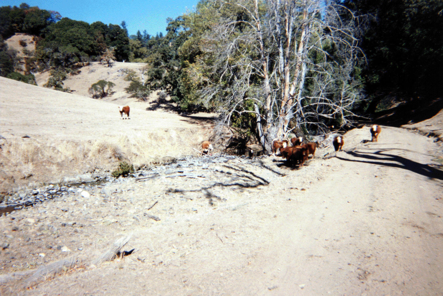
Cattle grazing in the Gualala basin is far below historic levels but at
some locations in stream side areas can retarded riparian recovery. The
photo at left also shows a road in proximity to the stream course, which
is likely to cause problems with chronic sediment yield. The photo was taken
during habitat typing surveys in 2001. Photo provided courtesy of California
Department of Fish and Game, North Coast Watershed Assessment Program.
|
|
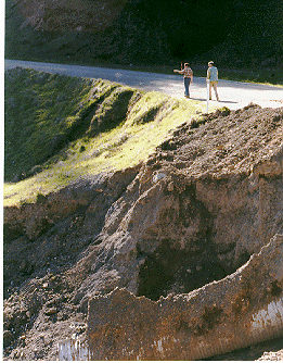
At left
is a picture of gully erosion off of Kelly Road in the upper Wheatfield
drainage. While Kelly Roads has had drainage improvements pursuant to its
transfer from the Army Corp of Engineers to private parties, it has not
been out-sloped and instead an in-board ditch has been maintained. The erodible
terrain of the Central Belt Franciscan melts under culverts discharging
water from the ditch to the hillslope. Photo by Pat Higgins.
|
|
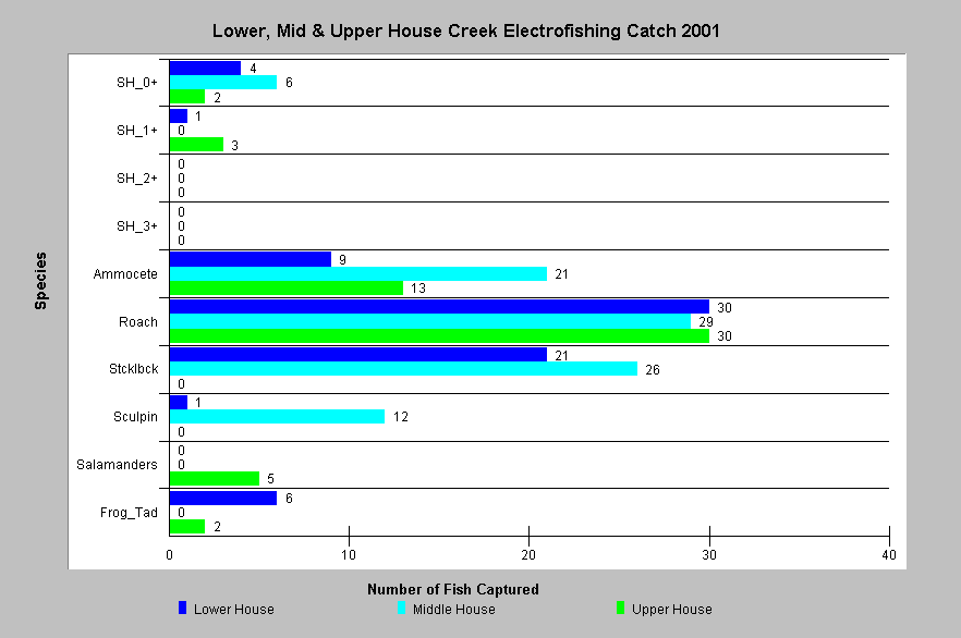
California Department of Fish and Game electrofishing in September 2001 showed that House Creek had steelhead young of the year (0+) and yearlings present at some sites but roach were the dominant fish represented in all three reaches. Roach are favored over steelhead in competition when water temperatures are elevated. The high number of ammocetes (Pacific lamprey juveniles) is not common in samples at other Gualala River basin sites. House Creek has a large reservoir on one of its larger tributaries Pepperwood Creek, which may contribute to flow depletion and, therefore stream warming. House Creek was formerly the eastern extent of coho salmon distribution in the Gualala basin. |
Gualala River Estuary Cumulative Watershed Effects
Changes in the Gualala River estuary are evident as sediment has worked its way down stream after past storm events. The diminished depth of the estuary is a concern because it may be one of the best salmonid rearing areas left in the Gualala. Concern also exists of water depletion in the North Fork Gualala by the Gualala Water Company (see note from Higgins (1997).
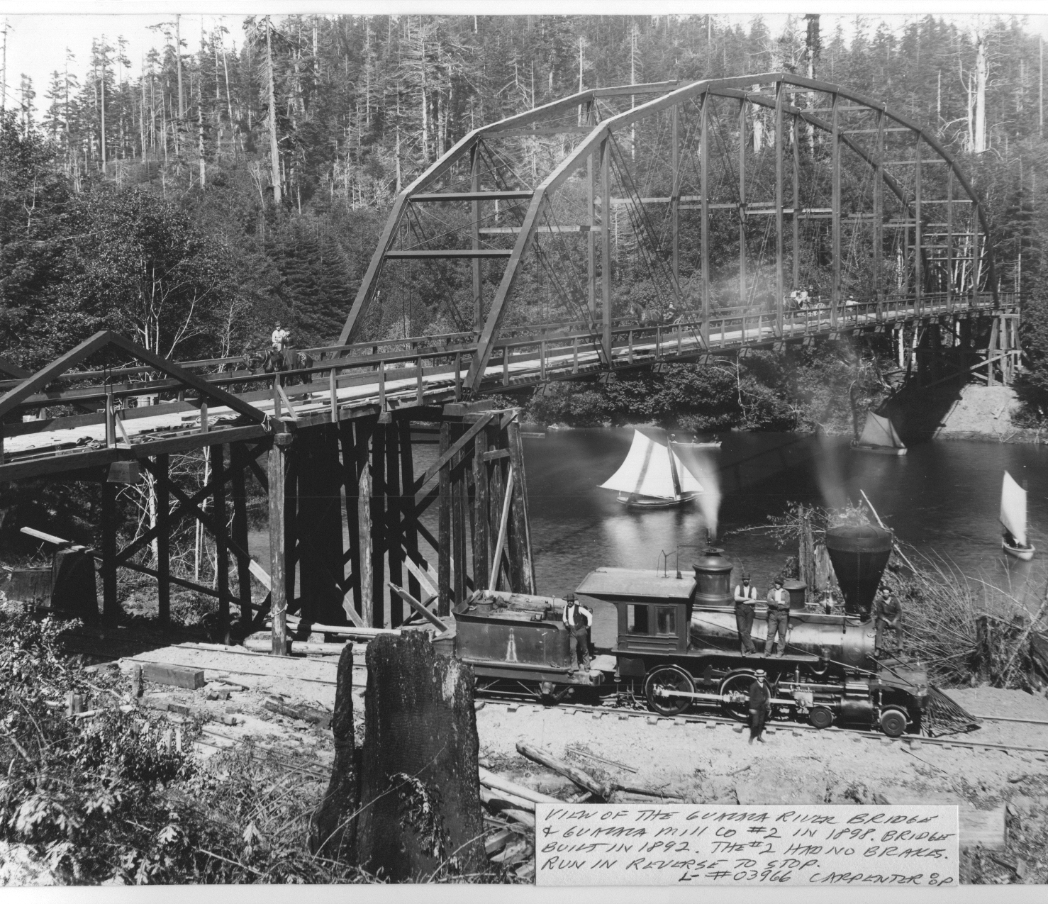 |
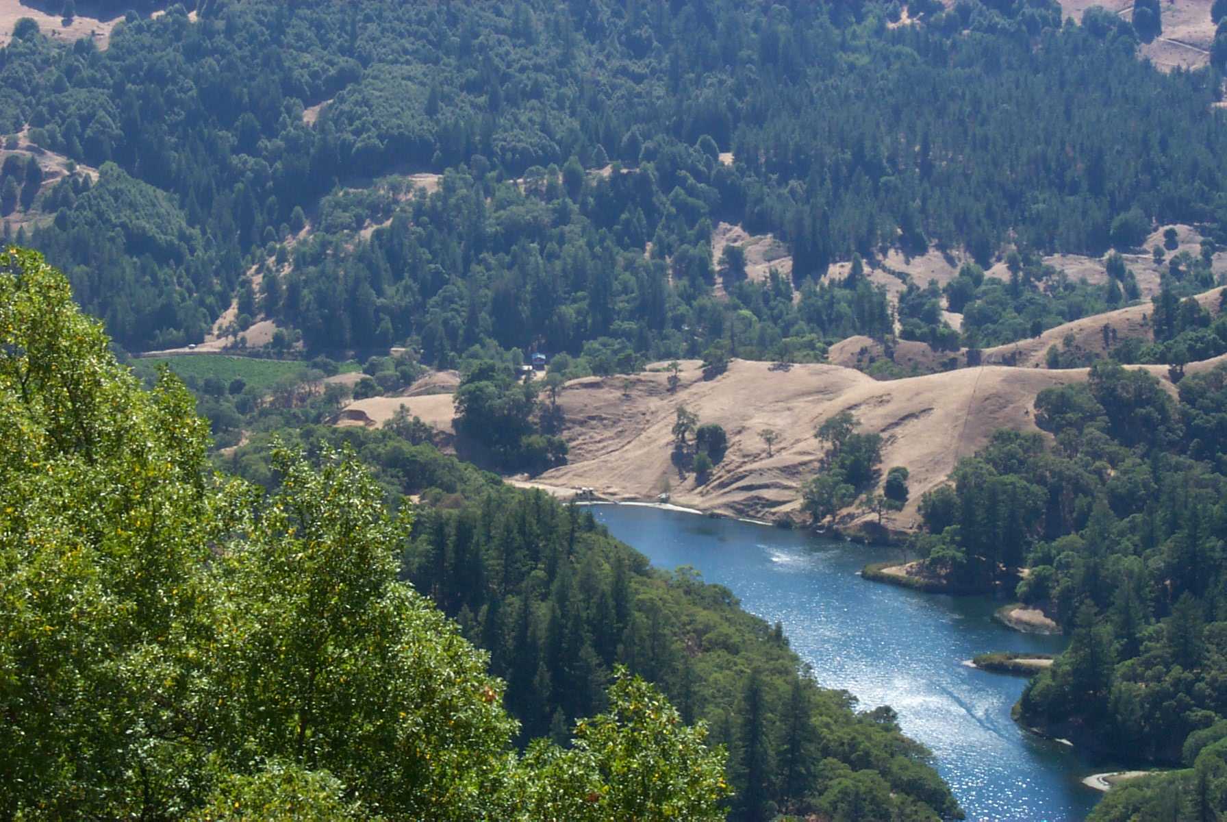
The
aerial photo at left shows the upper Gualala River estuary/lagoon in 1898
with sail boats underneath the bridge and old growth redwoods still standing
in a grove on the far side. The depth and complexity of the lagoon would
have been higher prior to sedimentation. Photo provided courtesy of the
Held-Poage Research Library and the Mendocino Historical Society from the
Robert Lee Collection (L#03966, Carpenter).
|
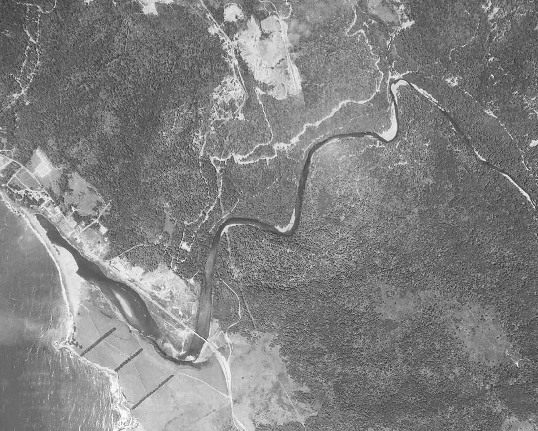 |
While the 1965 aerial photo at left shows some sign of aggradation from the 1964 flood as point bar deposits in upper right of photo and the shallowness of the lagoon. The Highway 1 Bridge is visible at lower right. Transport from tributaries of material deposited in 1964 continued in 1972 and 1974, subsequent high flow years. See the 1988 photo below to see more advanced aggradation in the lower Gualala. Photo scanned from the collection of the Ukiah office of the U.S. Natural Resources Conservation Service (NRCS) and the Mendocino Resources Conservation District. |
 |
The aerial photo at left shows the Gualala River estuary/lagoon in May 1988 with the Highway 1 Bridge visible at lower left. Aggradation is more advanced than in 1965 photos as evidenced by larger point bars, especially below the North Fork (red arrows). Lower flow conditions could also alter the amount of bars showing and 1988 was a fairly low flow year (based on Noyo River USGS gauge). Sediment impacts in this reach are at least in part owing to effects of 1964 flood as sediment cycles slowly out of lower gradient reaches of rivers such as the lower Gualala. Photo scanned from the collection of the Ukiah office of the U.S. Natural Resources Conservation Service (NRCS) and the Mendocino Resources Conservation District as part of Gualala River Literature Assimilation (Higgins, 1997). |
While some northwestern California river basins, such as the Garcia and the Mattole are showing signs of recovery, the Gualala falls into the class of a river still in decline.
![]()
References
Barnhart, R.A. 1986. Species profiles: life histories and environmental requirements of coastal fishes and invertebrates (Pacific Southwest)--steelhead. U.S. Fish Wildl. Serv. Biol. Rep. 82(11.60). U.S. Army Corps of Engineers, TR EL-82-4. 26 pp.
California Regional Water Quality Control Board (CRWQCB). 2001. Technical Support Document for the Gualala River Watershed Water Quality Attainment Action Plan for Sediment. CRWQCB, Region 1. Santa Rosa, CA. 147 pp.
California Resources Agency. In press. Gualala River Watershed Assessment. CA Dept. of Fish and Game, State Water Res. Control Bd., CA Dept. of Water Resources, CA Div. on Mines and Geology and CA Dept. of Forestry. Sacramento, CA. Draft released January 16, 2001.
Chen, G.K. 1992. Use of Basin Survey Data in Habitat Modeling and Cumulative Watershed Effects Analyses. As FHR Currents # 8. US Forest Service, Region 5. Eureka, CA. 11 pp.
Higgins, P.T. 1997. Gualala River Watershed Literature Search and Assimilation. Funded by the Coastal Conservancy under contract to Redwood Coast Land Conservancy. Gualala, CA. 59 pp.
Matthews, Graham and Associates. 2000a. Sediment source analysis and preliminary sediment budget for the Ten Mile River, Mendocino County, CA. Prepared for Tetra Tech, Inc. VOLUME 1: Text, Tables, and Figures. Fairfax, VA. 143 pp.
Matthews, Graham and Associates. 2000b. Sediment source analysis and preliminary sediment budget for the Ten Mile River, Mendocino County, CA. Prepared for Tetra Tech, Inc. VOLUME 2: Appendices. Fairfax, VA. 59 pp.
Nawa, R.K., C.A. Frissell and W.J. Liss. 1990. Life history and persistence of anadromous salmonid stocks in relation to stream habitats and watershed classification, annual progress report (4/18/90). Prepared for Oregon Department of Fish and Wildlife, by Oak Creek Laboratory of Biology, Department of Fisheries and Wildlife, Corvallis, OR.
Pacific Watershed Associates. 1998. Sediment Source Investigation and Sediment Reduction Plan for the Bear Creek Watershed, Humboldt County, California. Prepared for The Pacific Lumber Company Scotia, California. Arcata, California. 57 pp.
Reeves, G.H., F.H. Everest and J.R. Sedell. 1993 . Diversity of Juvenile Anadromous Salmonid Assemblages in Coastal Oregon Basins with Different Levels of Timber Harvest. Transactions of the American Fisheries Society. Vol 122, No. 3. May 1993.
Sidle, R. C. 1985. Factors influencing the stability of slopes. U.S.D.A. Forest Service General Technical Report PNW-180 April, 1985.
Taylor, S.N. 1978. The status of salmon populations in California coastal rivers. California Department of Fish and Game. Salmon/Steelhead Program, Anadromous Fisheries Branch. 14 pp.
![]()
| www.krisweb.com |