
| Area | Basin-wide/Regional |
| Topic | Roads: Densities in Humboldt Bay, All Sub-Basins 2000 |
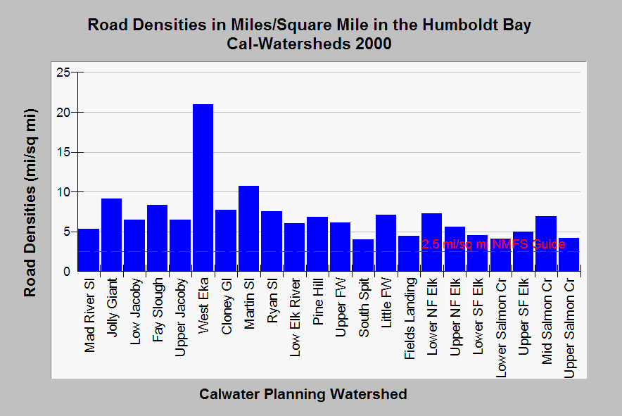
| Caption: This chart shows the road density within all Humboldt Bay Calwater Planning Watersheds as miles of road per square mile of watershed. Urbanized watersheds like West Eureka (EKA), Martin Slough, Jolly Giant and Fay Slough rank highest, but road densities on timber lands may also be high relative to thresholds recognized as leading to increased sediment yield and impairment of aquatic health. Proper watershed function for salmonid habitat according to National Marine Fisheries Service (1996) is 2.5 miles per square mile, which is shown as a reference above. Roads on timberlands may not reflect skid trails, temporary roads or tractor trails and so should be viewed as conservative. Data from Legacy the Landscape Connection with summary statistics generated by the Institute for Fisheries Resources. See Info Links for access to more background information. | |
 |
To learn more about this topic click Info Links .
To view additional information (data source, aquisition date etc.) about this page, click Metadata .
To view the table with the chart's data, click Chart Table web page.
To download the table with the chart's data, click road_dens_xing_hb_1999.dbf (size 2,008 bytes)
To download the table with the chart's data as an Excel spreadsheet, click road_dens_xing_hb_1999.dbf.xls (size 10,752 bytes) .
| www.krisweb.com |