Bibliography Background About KRIS
Hypothesis #5: Surface flows in the Navarro River basin have been diminished in recent decades, which reduces salmon and steelhead productivity.
Surface flow in Pacific Northwest streams can be influenced by rainfall and runoff patterns, dams and flow releases, but also by sediment yield. Streams draining northwestern California watersheds may sometime lose surface flow as a result of aggradation (Kier Associates, 1999). Coho salmon and Steelhead trout are aquatic creatures and, therefore, reduction in flow may decrease available habitat. Reduction in stream flows may also retard sediment transport, increase water temperatures, decrease dissolved oxygen and otherwise negatively influence salmonid fisheries productivity indirectly (Poole and Berman, 2000), however, secondary factors are not considered in this hypothesis. .
Support for the Hypothesis from the Navarro River Basin
The Friends of the Navarro Watershed and others (Volker, 1994) filed a water rights complaint with the California State Water Resources Control Board (SWRCB) Division Water Rights (DWR) for failing to adequately address instream flow needs under the Public Trust Doctrine in the Navarro River basin. In the complaint, Volker (1994) stated that:
"Illegal and unreasonable water diversions from the Navarro River and its tributaries, primarily for agricultural purposes, have significantly impaired instream fish and wildlife beneficial uses, to the point where the river was literally pumped dry during August and September of 1992. Such illegal and unreasonable diversions threaten again this fall to eliminate the natural flow of the river and its tributaries necessary to sustain constitutionally and statutorily protected instream fish and wildlife beneficial uses."
Volker (1994) noted that the California Department of Fish and Game also had concerns over flow issues and protection of fisheries and aquatic resources and that as of 1992 CDFG was filing protests on all new water rights permit applications in the Navarro River basin. CDFG (1994) explicitly recommended that the "SWRCB consider classifying the upper Navarro River watershed as fully appropriated during all but winter months."
The Mendocino County Water Agency (MCWA) (Jackson, 1991) presented information to the SWRCB DWR that flows in relation to rainfall and runoff had decreased in the Navarro River basin between 1951 and 1988 (Figure 1), while "the pattern of declining annual minimum streamflow has not been observed on the Garcia, Noyo or Ten Mile Rivers."
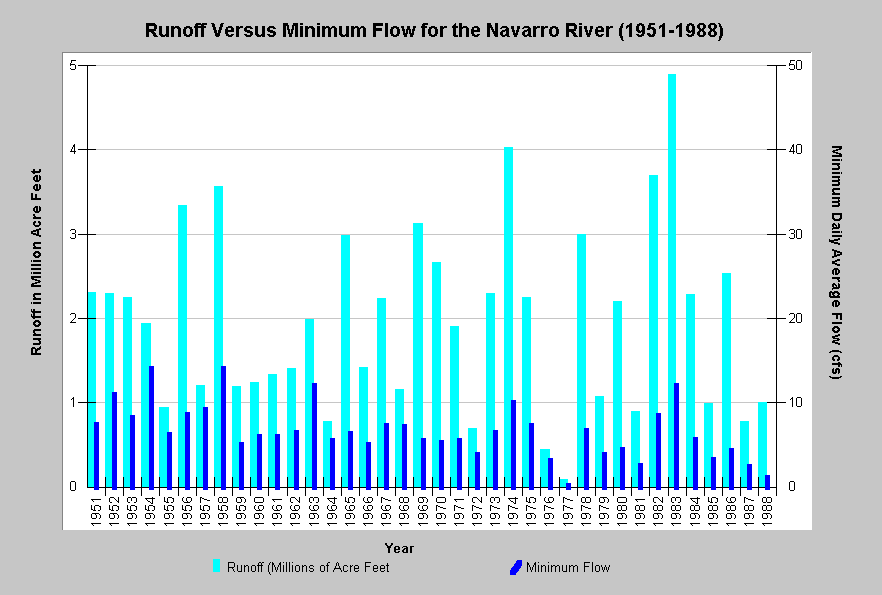 Figure 1. This chart shows the total estimated runoff from the Navarro River watershed as calculated by Jackson (1991) on the left axis in millions of acre feet (MAF) and minimum daily flow in cubic feet per second from the USGS stream gauge (11468000) near the mouth of the river from 1951 to 1988. Water years are defined from Oct 1 to Sept. 30 (i.e. water year 1951 = Oct 1, 1950-Sept 30, 1951). Jackson (1991) found that there was a pattern of lower surface flows for the amount of runoff between 1950 and 1988. A comparison of flow versus runoff for the water year 1955 (0.94 MAF and 6.2 cfs) with 1985 (0.99 MAF and 3.3 cfs) and 1988 (1 MAF and 1.1 cfs) illustrates this pattern.
The SWRCB DWR (1998) published the Report of Investigation on the Navarro River Watershed Complaint to address the instream flow issue and its effect on the decline of salmonids in the basin. Although the study did not agree that there was conclusive evidence that flow reductions related to agriculture were harming salmonids, flow measurements were taken that appear in Table 1. These data indicate that several tributaries lost surface flow and that many others had flows less than one cubic foot per second, despite the fact that both 1995 and 1996 were high rainfall years.
Table 1. Minimum flows measured at various locations in the Navarro River basin by the SWRCB DWR in 1995 and 1996. Flows are presented in cubic feet per second (cfs) with Dry indicating loss of surface flow at a location.
| Stream/Station | 1995 Minimum Flow | 1996 Minimum Flow |
| Rancheria Creek @ Fish Rock Road | <0.5 cfs | <0.5 cfs |
| Anderson Creek @ Highway 253 | 0.5 cfs | 0.55 cfs |
| Soda Creek @ Highway 253 | Dry | Dry |
| Robinson Creek @ Mt View Rd | Dry | Dry |
| Con Creek @ Anderson Valley Way | <0.05 | <0.05 |
| Anderson Creek on Best Property | Dry | Dry |
| Rancheria Creek Above Anderson | <5 cfs | 2.6 cfs |
| Anderson Creek Above Rancheria | <0.3 cfs | <0.3 cfs |
| Indian Creek @ Highway 128 | <2.5 cfs | 2 cfs |
| Navarro River @ Hendy Woods | <5 cfs | <5 cfs |
| Navarro River @ Husch | <3 cfs | 5 cfs |
| Mill Creek @ Highway 128 | <0.25 cfs | 0.2 cfs |
| North Fork Navarro @ Hwy 128 | <1 cfs | <1.5 cfs |
| Flynn Creek @ Highway 128 | Dry | <0.5 cfs |
| NF Navarro River near Dimmick SP | <2.5 cfs | <2 cfs |
A survey of water rights applications at the State Water Resources Control Board’s Division of Water Rights (SWRCB DWR) in May, 2002, found 237 records on file for the Navarro River basin (Figure 2). By comparison, the nearby Garcia River watershed had only 12. Water appropriations are granted for different seasons at different amounts for multiple uses, which can all come under the same water rights application. In addition, "the SWRCB identified 121 reservoirs in the Navarro River Watershed without any apparent water rights" (SWRCB, 1998). Figure 3 shows typical off stream and on-stream storage reservoirs. The SWRCB (1998) concluded that the Navarro be listed as fully appropriated between April 1 and December 14. The SWRCB DWR (1998b) subsequently formally recognized the Navarro as fully allocated in summer.
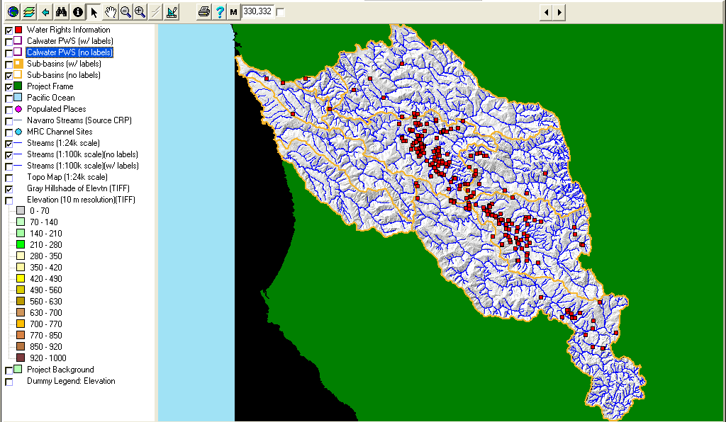 Figure 2. This is a map of water rights information from the State Water Resources Control Board displayed with USGS 1:100,000 hydrography, KRIS sub-basins, and a grayscale hillshade. Water rights listed may not be complete, since not all rights are registered, particularly riparian rights. Also, some water users may be extracting water or building retention ponds without permits.
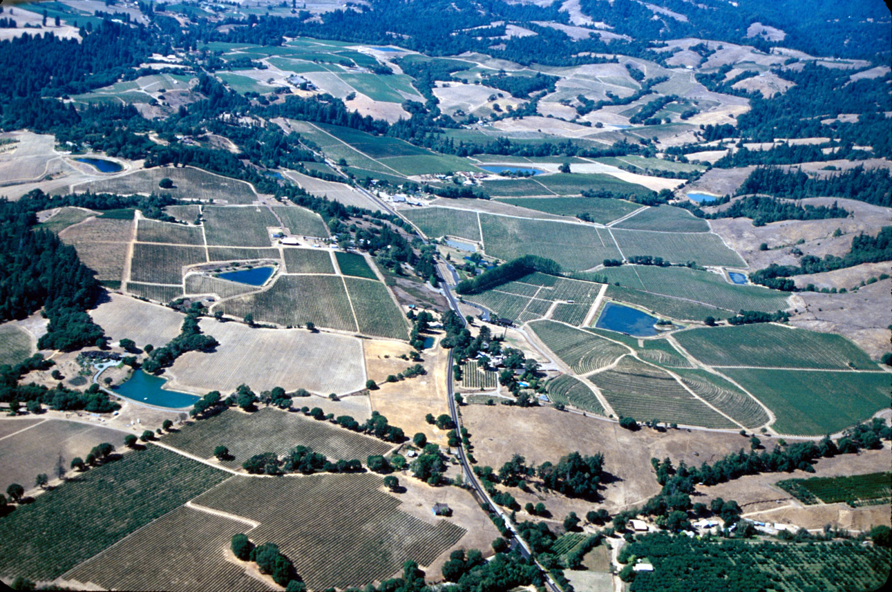 Figure 3. This aerial photo of agricultural development in the Navarro River basin near Mill Creek shows ten water storage ponds of different types, which are typical of water storage in the Navarro River basin. Vineyard development in the Navarro River watershed has put added pressure on water availability for salmonids. Photo by Rixanne Wehren.
The California Department of Fish and Game conducted habitat typing surveys of North Fork Navarro River tributaries which demonstrate that surface flow in the Navarro River basin may be lost as a result of aggradation (Figure 4). There is very little water diversion in the North Fork Navarro because it is timberland with a low density of residential settlement or agriculture.
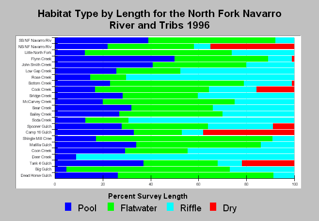 Figure 4. This chart shows habitat types by length for the North Fork Navarro River basin with frequency of pools, riffles, flatwater and dry reaches displayed. The extensive dry reaches in the North Branch North Fork, Camp 16 Gulch and Tank 4 Gulch all demonstrate that surface flow may be lost when a stream is buried deeply in sediment. Data from CDFG.
During field reconnaissance of the Navarro River basin in 2001 and 2002, the KRIS IFR team noted extensive reaches of the Navarro River and its tributaries, which lacked surface flows in summer and early fall (Figures 5-9).
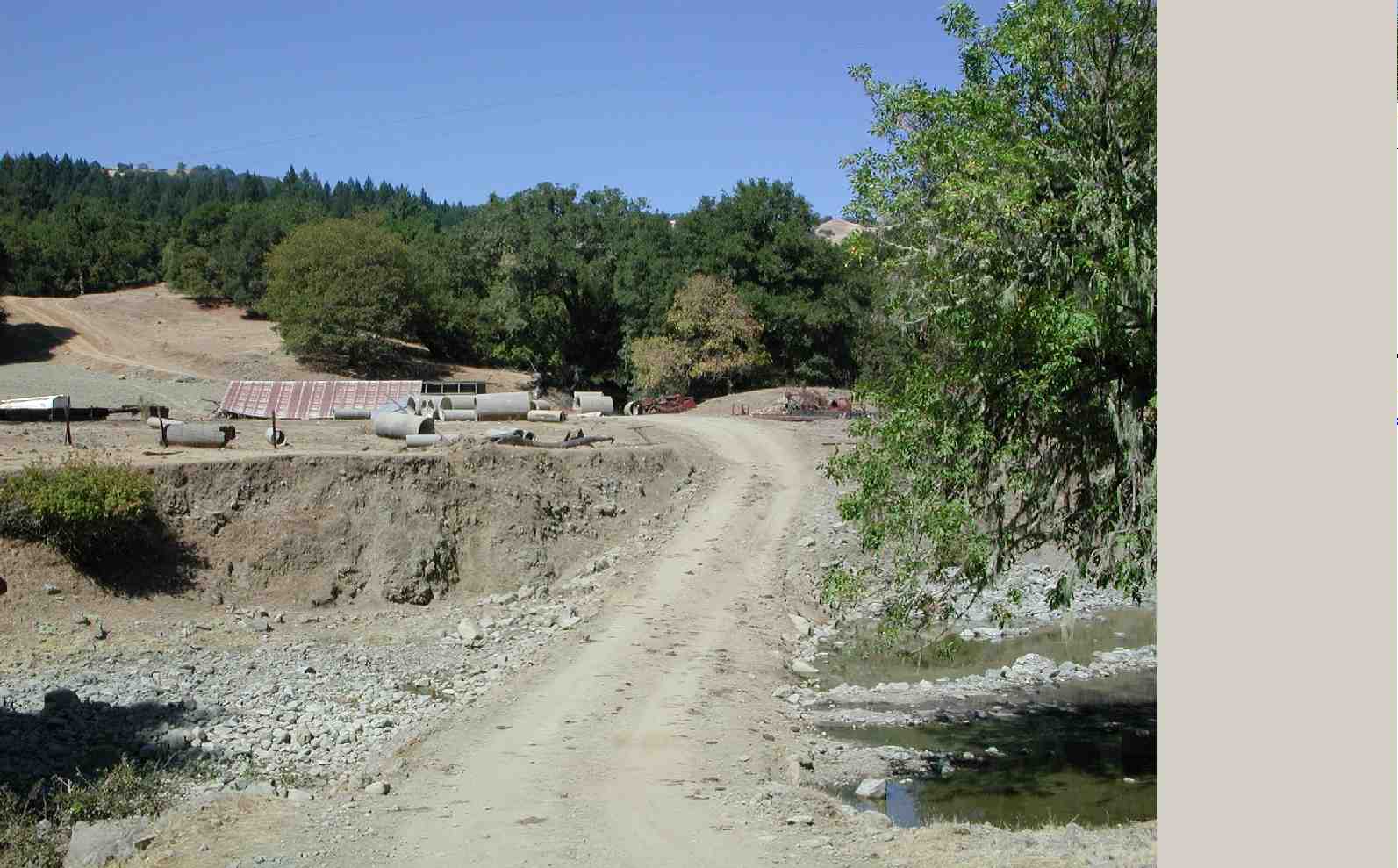 Figure 5. This is a view of temporary road blocking Beebe Creek near Highway 128 above its convergence with Rancheria Creek. This crossing formed a dam which caused flows to pond on the upstream side and to block downstream flows. Dry reaches constitute a constraint on salmonid production whether the origin of flow loss is diversion, aggradation or changes in runoff patterns as a result of cumulative watershed effects. Photo by Pat Higgins, 9/21/01.
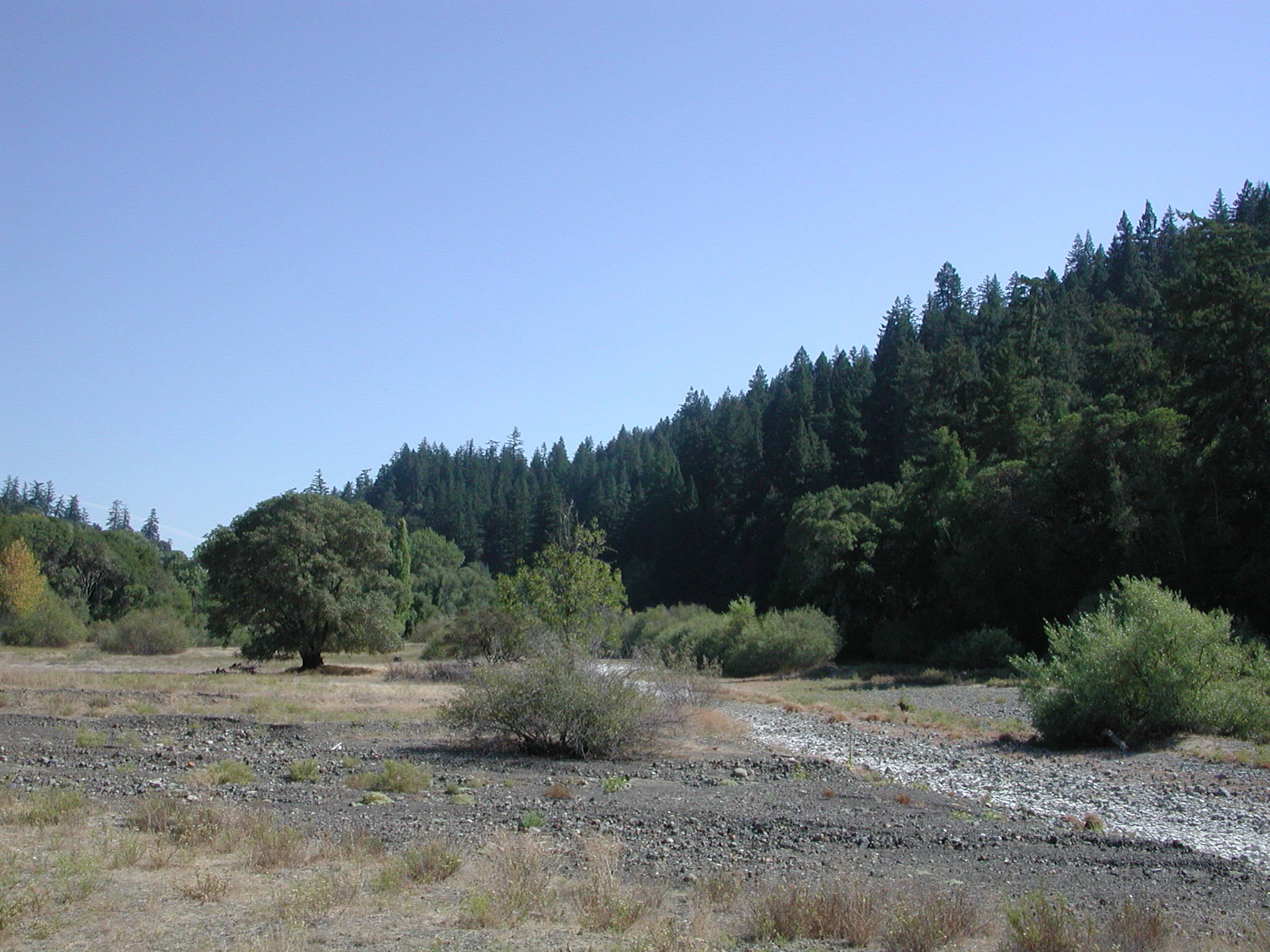 Figure 6. Shearing Creek enters Rancheria Creek from the left in this September 2001 photo, with both streams lacking surface flow at this location. Photo by Patrick Higgins, 9/21/01.
 Figure 7. Flynn Creek at Highway 128 lacked surface flow in late September 2001, as illustrated by this photo taken just upstream of the highway bridge. The very fine particle size of the stream bed indicates sediment of recent origin burying Flynn Creek and causing it to lose surface flow. Flynn Creek is a North Fork Navarro River tributary, a sub-basin that has little agricultural development or domestic water use yet has diminished fish habitat, possibly because of loss of surface flows. Photo by Patrick Higgins, 9/21/01
.
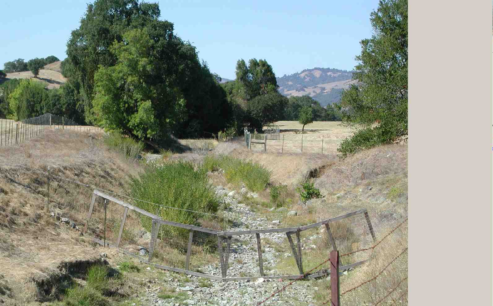 Figure 8. Robinson Creek, a tributary of Anderson Creek, looses surface flows in late summer as indicated by this September 2001 photo. The cumulative loss of rearing habitat for salmonids due to dry reaches is significant. Photo by Patrick Higgins, 9/21/01.
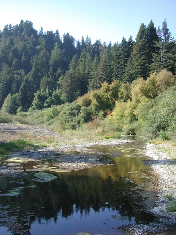 Figure 9. This is a view looking downstream on the lower mainstem Navarro River near Flume Gulch during low flow conditions on September 21, 2001. The USGS flow gauge indicated that the average flow on this day was 1.1 cubic feet per second. The mainstem Navarro begins to get stagnant at this flow level as indicated by the algae on the margins of the stream. The shallow flows and wide stream channel combine to exacerbate water temperature problems in the mainstem. Photo courtesy of Pat Higgins, 9/21/01.
Topics Supporting the Hypotheses
The following is a list of Topics in KRIS Navarro where you can see data in its context, Metadata and associated Info Links. The large-case letters in parentheses indicate KRIS sub-basins.
(MN) Flow: Navarro River - Runoff vs. Flows, 1951-1988
(BW) Map: 5B Water Rights Locations, Navarro Project Area
(BW) Tour: Anderson Valley air photos 2001
(NF) Habitat: Habitat Types by Length North Fork Navarro Sub-basin 1996
(RC) Tour: Upper Rancheria Creek and Tributaries Channel Photos 2001 Part 3
(RC) Tour: Upper Rancheria Creek and Tributaries Channel Photos 2001 Part 4
(NF) Tour: Flynn Creek Dry Season Photos 2001
(AC) Tour: Robinson Creek channel photos 2001-02
(MN) Tour: Mainstem Navarro River photos 2001
Alternative Hypothesis
Factors other than flow are causing the problems related to salmonid productivity in the Navarro River basin.
The SWRCB (1998) favors this alternative hypothesis having stated: "the cause of the anadromous fish decline may be principally due to factors other than flow, and there is not enough information available regarding the needs of the fishery in the summer."
Monitoring Trends to Test the Hypotheses
To adequately address flow issues in the Navarro River watershed and test these hypotheses, a water balance analysis is necessary to investigate seasonal and yearly trends in precipitation, river flows, groundwater storage, and actual diversion volumes. Such an analysis could directly address water appropriation and instream flows as limiting factors for salmonid production. A comparative analysis involving other watersheds would also help clarify issues in the Navarro River basin by characterizing the local water budget in a regional context.
References
California Department of Fish and Game (CDFG). 1994. Letter from J.L. Turner to B. Fodge (California State Water Resources Control Board), 01 February 1994, regarding proposed 200 cfs bypass on Navarro River . CDFG unpublished file memo. Yountville, CA. 2 pp. [10kb]**
California State Water Resources Control Board (SWRCB). 1998. Report of investigation on the Navarro River watershed complaint in Mendocino County. Complaint Unit, Division of Water Rights, SWRCB . Sacramento, CA. 73 pp. [1.8Mb]**
Jackson, D. 1991. Letter to R. Swenerton (State Water Resources Control Board), 22 May 1991, regarding concern for Navarro River . Mendocino County Water Agency . Ukiah, CA . 7 pp. [120kb]**
Jackson, D. 1998. Letter to E. Anton (State Water Resources Control Board), 17 August 1998, regarding Report of investigation on the Navarro River watershed complaint in Mendocino County, July 1998. Santa Cruz, CA. 4 pp. [26kb]**
Kier Associates. 1999. Mid-term Evaluation off the Klamath River Basin Fisheries Restoration Program. Prepared for the Klamath River Basin Fisheries Task Force, USFWS, Yreka, CA by Kier Associates, Sausalito, CA. 303 pp.
Poole, G. C. and C. H. Berman. 2000. Pathways of human influence on water temperature dynamics in stream channels. Environmental Management. 20 pp. [250kb]
Volker, S. 1994. Complaint and petition to restrain illegal diversions of water from, amend water appropriation licenses and permits to assure bypass flows sufficient to protect instream fish and wildlife, beneficial uses within, restrain unreasonable riparian uses and appropriations of, and declare fully appropriated, the Navarro River and its tributaries. August 24, 1994. Sierra Club Legal Defense Fund, Inc . San Francisco, CA. 21 pp. [911kb]**