
| Area | Basin-wide |
| Topic | Vegetation: USFS/CDF Landsat Change Scene Detection 1991-1999 |
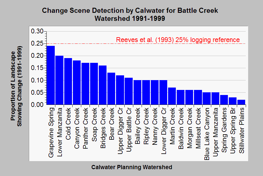
| Caption: This bar chart shows the amount of change in vegetation in the Battle Creek watershed by Calwater Planning Watershed between 1991 and 1999 calculated by combining 1991-1996 and 1994-1999 change scene data based on Landsat imagery. This change scene data includes both decrease and increases in vegetation, which is assumed to reflect both harvest and growth from logging in the 10-15 years prior to 1991. Other factors that may change vegetation are fire, agricultural or housing development. The watersheds could be grouped into four disturbance classes: High (>15%), Moderate (10-15%), Low Change (5-10%) and Very Low Change (<5%). The reference line is from Reeves et al. (1993) and reflects Oregon studies that showed decreases in Pacific salmon species diversity when watersheds were logged over 25% in a 30 year period. The relationship of logging disturbance and aquatic response has not been established for the Sierra Nevada and this relationship is shown only for reference. Summary run by Dr. Paul Trichilo of Kier Associates. See Info Links for more information. | |
 |
To learn more about this topic click Info Links .
To view additional information (data source, aquisition date etc.) about this page, click Metadata .
To view the table with the chart's data, click Chart Table web page.
To download the table with the chart's data, click change_scene_1991_1999_combo.dbf (size 1,358 bytes)
To download the table with the chart's data as an Excel spreadsheet, click change_scene_1991_1999_combo.dbf.xls (size 5,120 bytes) .
| www.krisweb.com |