| Bibliography | Background | Hypotheses | Home | |
| Bibliography | Background | Hypotheses | Home | |
![]()
|
The area of vegetation near streams is known as the riparian zone. A riparian zone helps maintain good stream habitat for salmon, steelhead and coastal cutthroat trout in the following ways: |
· Helps maintain cool
water temperatures through provision of shade and creation of a cool and humid
microclimate over the stream
· Provides food resources for the aquatic ecosystem in the form of leaves, branches,
and terrestrial insects
· Stabilizes banks through provision of root cohesion on banks and floodplains
· Filters sediment from upslope sources
· Filters chemicals and nutrients from upslope sources
· Supplies large wood to the channel which maintains channel form and improves
in-stream habitat complexity
· Helps maintain channel form and in-stream habitat through the restriction
of sediment input or slowing of sediment moving through the system
· Moderates downstream flood peaks through temporary upstream storage of water
|
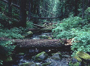
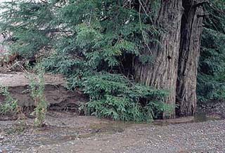
This
rootwad provides excellent habitat for coho salmon and steelhead juveniles
in the winter, when the water is high. Fish hide behind it to avoid getting
washed downstream during high flows. Large redwoods that fall into the stream
may last several hundred years before decaying. These trees play a critical
role in provision of aquatic habitat diversity in northwestern California. Photo by Pat Higgins. [42 kb] |
 |
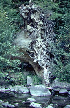
The
multi-level canopy over this stream keeps air and water temperatures cool.
Fallen trees help create the complex habitat that salmon and steelhead need. The
return of the salmon and their death after spawning brought a great store
of nutrients from the ocean, which helped the riparian forests to thrive. Photo by Bill Filsinger [29 kb] |
Considerable study and discussion has taken place in recent years regarding riparian zone protection. Protection zone distances are often referred to in site potential tree heights which is the expected height of coniferous trees upon maturity (200 years). This averages 170 feet in much of the Pacific Northwest, but may exceed 200 feet in areas such as the Olympic Peninsula or the redwood zone in California (Spence et al., 1996). The Northwest Forest Plan (FEMAT, 1993) recognized the importance of maintaining riparian protection on Federal lands for both Pacific salmon and amphibian species and recommended buffer widths of two site potential tree heights on perennial streams and one site potential tree height on ephemeral water courses. Zones of protection under FEMAT (1993) are also extended to the break in slope of the inner gorge to prevent landsliding. Kondolf et al. (1996) recommended a riparian buffer with a minimum of one site potential tree height for protection of Sierra Nevada streams.
Spence et al. (1996) concur with one site potential tree height buffer widths on private land as part of Habitat Conservation Plans. California Forest Practice Rules (CFPR) have some restrictions on timber harvest and equipment operation in riparian zones which vary with the steepness of surrounding slopes (Table 1). However, these protections do not restrict harvest of conifers and do not prevent harvest of all trees adjacent to ephemeral streams when slopes are less than 30%. Further restrictions on riparian harvest in California were recommended by Ligon et al. (1999) and improved protections were implemented under the Pacific Lumber Company Habitat Conservation Plan (PALCO HCP) (Table 1).
|
Jurisdiction |
Class I (Fish Bearing) |
Class II (Non-Fish Bearing) |
Class III (Ephemeral) |
|
FEMAT |
Two Site Potential Tree Heights = 340-400 ft. No Cut |
Two Site Potential Tree Heights = 340-400 ft. No Cut |
One Site Potential Tree Height 170-200 ft. No Cut |
|
California Forest Practice Rules |
75 ft. selective harvest on <30% slope 100 ft. selective harvest on 30-50% slope 150 ft. selective harvest on >50% slope |
50 ft. selective harvest on <30% slope 75 ft. selective harvest on 30-50% slope 100 ft. selective harvest on >50% slope |
Decided on site-specific basis. 25 ft. equipment exclusion zone on slope >30% |
|
PALCO HCP |
170 ft. protection zone* 0-100 ft. no cut 100-170 ft. retain 240 sq. ft. basal area |
100 ft. protection zone* 0-30 ft. no cut 30-130 ft. retain 240 sq. ft. basal area |
50 ft. protection zone** 0-30 ft. no cut 30-50 ft. selective harvest (<40% basal area removal) |
* May be modified through
watershed analysis
** May be modified through watershed analysis but also PALCO may choose 2175
acres of Class III
stream areas from its holdings where greater timber harvest
may take place.
Even the enhanced protection afforded streams by the PALCO HCP may not be sufficient in light of recent studies of blow-down in riparian zones after adjacent areas were clear-cut (Reid and Hilton, 1998). Reid and Hilton (1998) found increased tree fall rates from blow down in riparian zones as far as 200 meters from the edge of clear cuts in the North Fork Caspar Creek basin. They also found that 30% of trees recruited to the stream were knocked in by "trigger trees" which were outside one site potential tree height. It seems likely that large wood recruitment could be substantially altered by blow down under the HCP with only 100 foot and 30 foot no cut zones on Class I and II streams, respectively, and clear cuts allowed up to the edge of the outer band width (170 feet and 100 feet).
|
Recent regional
studies have demonstrated that existing riparian protection under CFPRs
are insufficient (Ligon et al., 1999). Pacific Watershed Associates (1998a)
found that timber harvest in ephemeral streams in the Elk River basin,
tributary to Humboldt Bay, lead to greatly elevated sediment yield. Steep
slopes in the inner gorge of Bear Creek, tributary to the lower Eel River,
failed after timber harvest, sending sediment 8 to 15 feet deep down the
stream channel (PWA, 1998b). The debris torrent run-out distance in Bear
Creek was substantially increased because landslides lacked large wood.
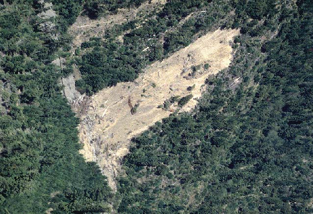
The example at left is in neighboring Jordan Creek and it shows an inner
gorge landslide associated with recent cable logging in an area
that would be protected on National Forest lands. The removal of most
large coniferous trees from the riparian over-story has also caused elevation
of stream temperatures, sometimes to levels that no longer support coho
salmon or sensitive amphibian species (see Temperature).
|
|
These trees have
trapped sediment that was moving downstream during high flows in Bear
Creek, Humboldt County, in 1997. A healthy riparian zone can trap soil
already in transit from uplands, thus reducing sediment impacts to downstream
reaches, as tree roots bind the soil and build terraces. Riparian trees
also block sediment coming directly from the adjacent land, which helps
to reduce and moderate the rate of sediment input to the stream.
|
|
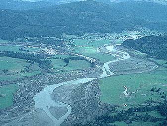
The
Van Duzen River, with Yager Creek entering from the left in 1997. The riparian
zone of the Van Duzen has expanded substantially in width due to substantial
quantities of sediment in transport and valuable dairy land is being eroded.
Photo by Pat Higgins. [29 kb] |
Even if riparian zones are protected from timber harvest or other land use activities, elevated sediment transport can overwhelm them (see Van Duzen photo above). Consequently, riparian protection must be accompanied by control of cumulative effects in upland areas to achieve salmon restoration objectives. Grant (1988) discovered that sequential aerial photos from different time periods can show changes in the width of riparian areas which are indicative of cumulative watershed effects. Watersheds suffering cumulative effects show expanding stream widths and those in recovery, such as the North Fork Garcia River, show riparian encroachment (Hagans and Higgins, 1996).
On the East Coast, Welsch (1991) recommended a minimum of 100 foot buffer strips surrounding agricultural lands for protection of aquatic resources, particularly for nutrient buffering. Smith and Prichard (1992) recommend several steps for restoring riparian zones.
![]()
References
CDF [California Department of Forestry and Fire Protection]. 1998. California Forest Practice Rules Forest Practice. CDF, Sacramento, CA.
FEMAT [Forest Ecosystem Management Assessment Team]. 1993. Forest Ecosystem Management: an ecological, economic and social assessment. Report of the Forest Ecosystem Management Assessment Team. 1993-793-071. U.S. Govt. Printing Office.
Grant, G. E. 1988. The RAPID technique: A new method for evaluating downstream effects of forest practices on riparian zones. Gen. Tech. Rep. PNW-GTR-220. Portland, OR: U.S. Dept. of Agriculture, Forest Service, Pacific Northwest Research Station. 36 p.
Hagans, D.K. and P.T. Higgins. 1996. Analysis of Stream Channel Recovery of the North Fork Garcia River Using a Modified RAPID Methodology. Performed under contract to Coastal Forest Lands, Inc. Willits, CA. 5 p.
Kondolf, G.M.; R. Kattelmann, M. Embury, D.C. Erman. 1996. Status of riparian. In: Sierra Nevada Ecosystem Project: Final report to Congress, vol. II, Assessments and scientific basis for management options. Wildland Resources Center Report no. 37. Davis, CA: University of California, Centers for Water and Wildland Resources; 1009-1030.
Ligon, F., A. Rich, G. Rynearson, D. Thornburgh, and W. Trush. 1999. Report of the Scientific Review Panel on California Forest Practice Rules and Salmonid Habitat. Prepared for the Resources Agency of California and the National Marine Fisheries Service. Sacramento, CA. 181 pp.
Pacific Watershed Associates. 1998. Sediment Source Investigation and Sediment Reduction Plan for the North Fork Elk River Watershed, Humboldt County, California. Report to The Pacific Lumber Company. Scotia, CA.
Pacific Watershed Associates. 1998b. Sediment Source Investigation and Sediment Reduction Plan for the Bear Creek Watershed, Humboldt County, California. Prepared for The Pacific Lumber Company Scotia, California. Arcata, California. 57 pp.
Reid, L.M. and S. Hilton. 1998. Buffering the Buffer. In: Proceedings of the Conference on Coastal Watersheds: The Caspar Creek Story. U.S.D.A. Forest Service, Pacific Southwest Forest and Range Experiment Station, Redwood Sciences Lab, Arcata, CA. http://www.psw.fs.fed.us/Tech_Pub/Documents/gtr-168/08reid.pdf
Smith, B. and D. Prichard. 1992. Riparian Area Management: Management techniques in riparian areas. Technical Reference 1737-6. U.S. Department of the Interior, Bureau of Land Management. Denver, CO. 48 pp. [119k]
Spence, B.C., G.A. Lomnicky, R.M. Hughes and R. P. Novitzki. 1996. An Ecosystem Approach to Salmonid Conservation. Funded jointly by the U.S. EPA, U.S. Fish and Wildlife Service and National Marine Fisheries Service. TR-4501-96-6057. Man Tech Environmental Research Services Corp., Corvallis, OR. http://www.nwr.noaa.gov/1habcon/habweb/ManTech/front.htm#TOC
Welsch, D. J. 1991. Riparian Forest Buffers; Function and design for protection and enhancement of water resources. USDA publication NA-PR-07-91 http://www.na.fs.fed.us/spfo/pubs/n_resource/buffer/cover.htm
![]()
|
Table of Contents for Background Pages |
|||||
| Stream Conditions: | Water Quality | Sediment | Riparian | Big Wood | Habitat Types |
| Watershed Conditions: | Vegetation Types | Slope Stability | Roads & Erosion | Cumulative Impacts | Urbanization |
| Fish & Aquatic Life: | Fish Populations | Amphibians | Aquatic Insects | Hatcheries | Fish Disease |
| Restoration: | Stream Clearance | In-stream Structures | Riparian | Watershed | Strategy |
| Geology / Hydrology: | Geology | Soils | Precipitation | Stream Flow | Channel Processes |
| Policy & Regulation | ESA | TMDL | Forest Rules | 1603 Permits | Water Rights |
| www.krisweb.com |