 |
 |
| Background | Hypotheses | Bibliography | Maps | Home |
|
|
| Background | Hypotheses | Bibliography | Maps | Home |
KRIS Ten Mile Map: Fish and Aquatic Habitat View
![]()
Hydrology, stream habitat, fish and aquatic biota are the central focus of this KRIS Ten Mile Map project View. Little spatial data on fisheries resources was available for the Ten Mile basin. This View shows Hawthorne Timber Company monitoring locations for fish and other aquatic vertebrate species and for sediment, temperature and aquatic invertebrate (Ambrose et al., 1996; Ambrose and Hines, 1996 and 1997; Hines, 2000). Knopp's (1993) sediment sampling locations are also found as a theme in this View. The U.S. Geologic Survey topographic map is used as a reference theme in this project. Stream gradient, which was derived from 10 meter DEM data provided by the California Department of Forestry, is very useful for analyzing likely historic distribution of coho in the Ten Mile basin.
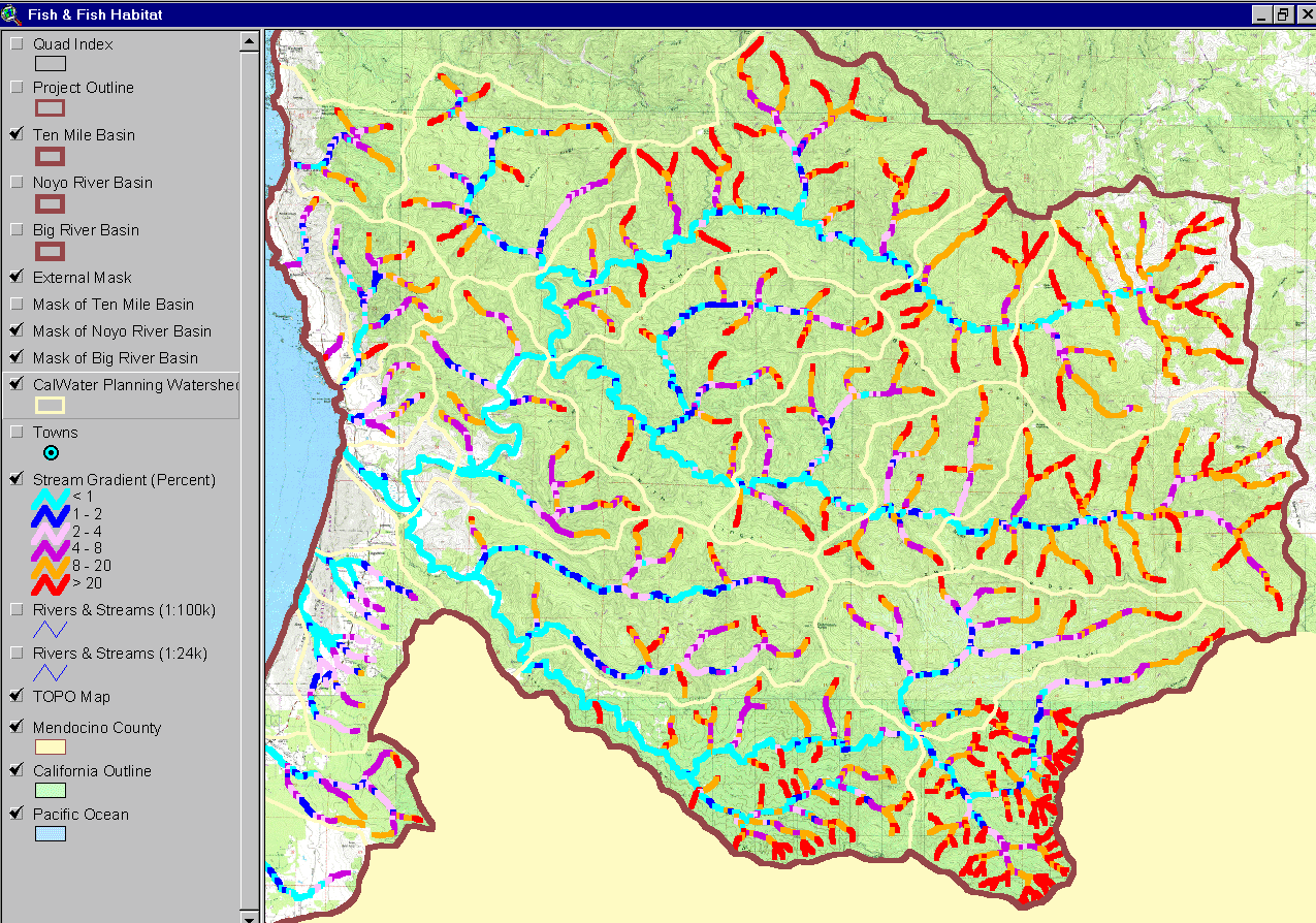 |
This image from the KRIS Ten Mile ArcView project shows the stream gradients of the Ten Mile River and its tributaries. Note that mainstem reaches are less than 2% gradient (light or dark blue) and that only a few tributaries like Churchman, Redwood and Bear Haven Creeks, as well as the Little North Fork, have long low gradient reaches. Therefore, it is likely that coho inhabited these mainstem reaches historically. |
|
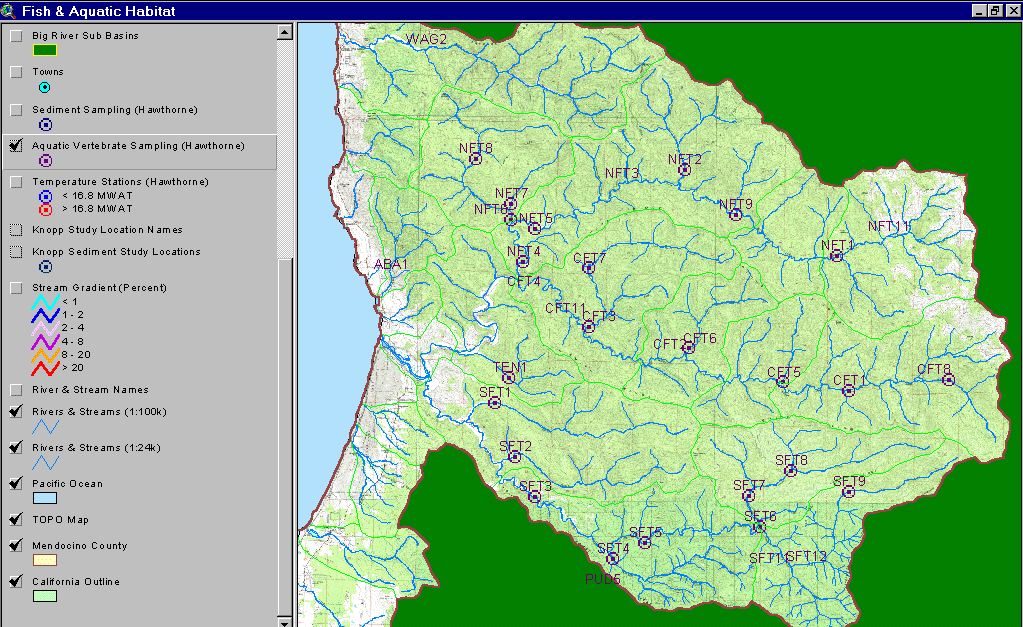
The image at left shows the KRIS Ten Mile project area, including coastal tributaries to the north and south, with locations of Hawthorne Timber Company fish and aquatic vertebrate sampling locations. For results of vertebrate sampling, see Fish Population Information in KRIS Ten Mile and Amphibian Information in KRIS Ten Mile |
 |
The image at left shows Hawthorne Timber Company sediment sampling stations in the Ten Mile River basin. To find out about data gathered at these locations, see Sediment Information in KRIS Ten Mile |
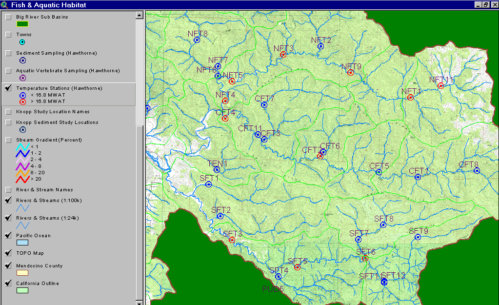 |
This image from the KRIS Ten Mile ArcView project shows the location of HTC temperature data collection stations with coding as to whether temperatures at the sites exceeded a maximum weekly floating average temperature of 16.8° C in any year measured. Most tributaries and low order, upper reaches of main stems are cool enough for coho except for the upper North Fork in grassland areas near Patsy Creek. Mid and lower reaches of the South Fork and Middle Fork are elevated to temperatures not likely to support coho in some or all years measured. |
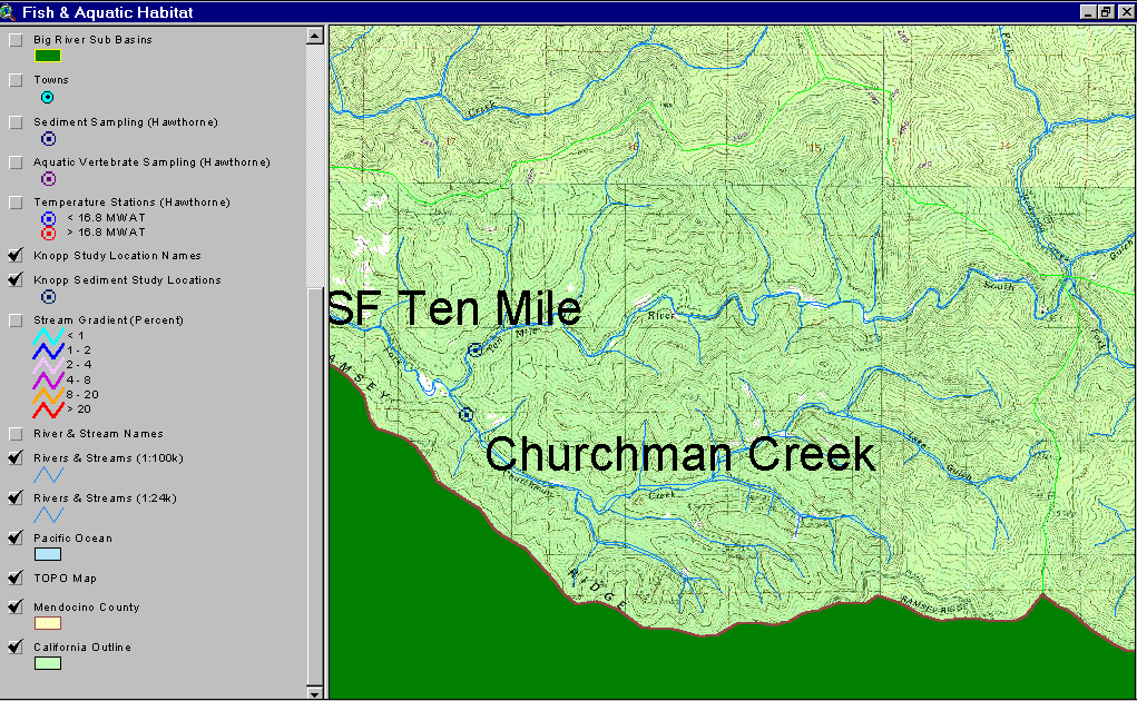 |
The image at left from the Fish and Aquatic Habitat View of the KRIS Ten Mile Map project shows Knopp (1993) sampling sites. To find out more about data from these locations, see Sediment Information in KRIS Ten Mile |
![]()
References
Ambrose, J., D. Hines, D. Hines, D. Lundby, and J. Drew. 1996. Ten Mile River Watershed 1995 Instream Monitoring Results. Volume I. Georgia-Pacific West Inc. Fort Bragg, CA. 84 pp.
Ambrose, J., and D. Hines. 1997. Ten Mile River Watershed 1996 Instream Monitoring Results. Georgia-Pacific West Inc. Fort Bragg, CA. 55 pp.
Ambrose, J., and D. Hines. 1998. Ten Mile River Watershed 1997 Instream Monitoring Results. Georgia-Pacific West Inc. dba The Timber Company. Fort Bragg, CA. 51 pp.
Knopp, C. 1993. Testing Indices of Cold Water Fish Habitat. Final Report for Development of Techniques for Measuring Beneficial Use Protection and Inclusion into the North Coast Region's Basin Plan by Amendment of the.....Activities, September 18, 1990. North Coast Regional Water Quality Control Board in cooperation with California Department of Forestry. 57 pp.
![]()
KRIS Ten Mile Map Views:
| www.krisweb.com |